Information
Landmark: Mullerthal Trail (Little Switzerland)City: Echternach
Country: Luxembourg
Continent: Europe
The Mullerthal Trail, also known as Little Switzerland, is one of Luxembourg’s most famous and scenic hiking routes, renowned for its stunning natural landscapes, unique rock formations, and picturesque forests. It is located in the Mullerthal Region, an area in the eastern part of Luxembourg, which is often referred to as the country’s “Little Switzerland” due to its mountainous terrain, lush greenery, and dramatic rock formations.
Key Features of the Mullerthal Trail:
1. Overview of the Mullerthal Region:
- The Mullerthal Region is situated in the northeastern part of Luxembourg and is characterized by its rugged terrain, dense forests, and unique rock formations made from sandstone.
- The region is part of the larger Ardennes mountain range and is known for its natural beauty, with rocky cliffs, caves, and gorges scattered throughout the landscape.
- It is a popular destination for outdoor activities, particularly hiking and nature walks, thanks to its well-maintained trail system and abundant natural features.
2. The Mullerthal Trail Route:
- The Mullerthal Trail consists of a network of three main loops that cover a total of approximately 112 kilometers (about 70 miles) of hiking trails.
- The trail offers a variety of hiking experiences, ranging from easy walks to more challenging routes, making it accessible to hikers of all levels.
- The trail is divided into three main loops:
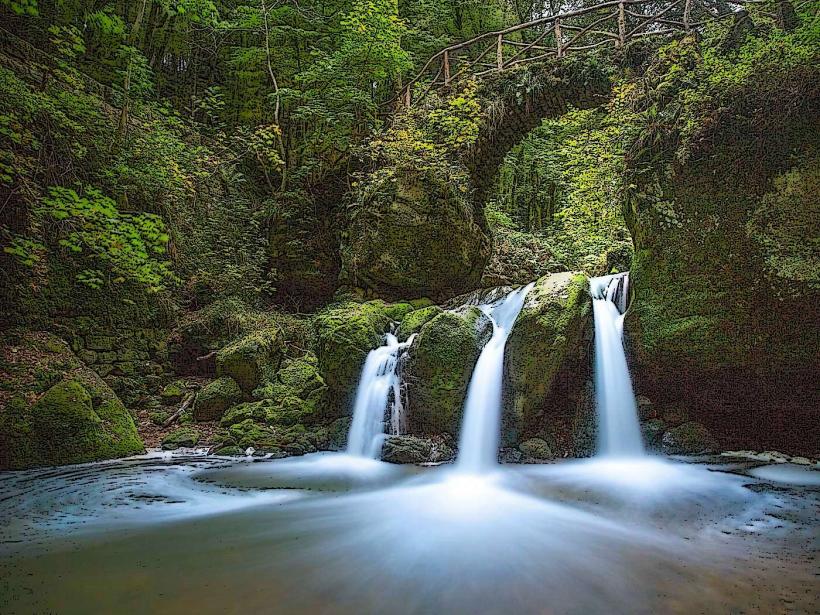
- Route 1 (37 km): This loop is considered the most scenic, taking hikers through dramatic rock formations, dense forests, and past the famous Schiessentümpel Waterfall.
- Route 2 (38 km): This loop offers a more diverse landscape, with picturesque villages, beautiful valleys, and interesting rock formations along the way.
- Route 3 (37 km): This loop features a slightly more hilly terrain, with breathtaking views over the Sauer Valley and numerous rocky outcrops.
Each route is marked with distinctive signs, and the loops can be completed individually or combined for a longer hiking experience.
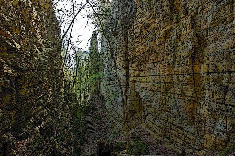
3. Unique Rock Formations and Landscapes:
- One of the standout features of the Mullerthal Trail is its rock formations. The region is famous for its sandstone cliffs, gorges, and caves, which were formed over millions of years through erosion.
- The most famous of these formations include:
- The "Devil’s Canyon" (Teufelskanzel): A dramatic rock formation that overlooks a narrow gorge.
- The "Rock of Heringer": A towering rock outcrop that is a popular stop on the trail.
- Schiessentümpel Waterfall: A stunning waterfall surrounded by lush forest, one of the most photographed spots in the region.
- These unique rock formations are complemented by dense forests, rolling hills, and streams, creating a picturesque and serene environment perfect for hiking.
4. Highlights Along the Mullerthal Trail:
- Schiessentümpel Waterfall: This waterfall is one of the most iconic sights along the trail. It is a small, but picturesque, waterfall nestled in the forest, often surrounded by moss-covered rocks and trees.
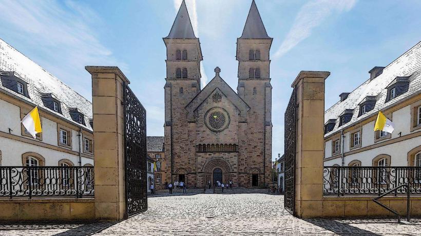
- The Abbey of Echternach: Located at the beginning or end of the trail (depending on the direction), the Abbey of Echternach is a significant historical site in Luxembourg and provides a cultural and architectural complement to the natural beauty of the Mullerthal Region.
- Caves and Grottos: The region features numerous caves and grottoes that can be explored, including the Grotte de Saint-Jean and the Grotte de Mersch.
- Wildlife and Flora: The area is home to a variety of wildlife, including birds, deer, and foxes. The forests are rich in native flora, including beech trees, oak trees, and a variety of wildflowers.
5. Trail Accessibility and Difficulty:
- The Mullerthal Trail is well-maintained and clearly marked with directional signs to guide hikers along the routes. The terrain can vary, with some parts of the trail being more rugged and others offering easier walks.
- Route 1 is often considered the most popular, with moderate difficulty and many highlights along the way. It features sections with rocky paths, streams, and waterfalls, making it a favorite for nature lovers and photographers.
- Route 2 is known for being a bit more challenging, with steeper sections and fewer facilities along the route. It also offers more open, scenic views of the valleys.
- Route 3 is also fairly challenging, with hilly terrain and more remote areas. It is recommended for hikers who are looking for a longer and more adventurous experience.
- Trail maps and detailed descriptions of the routes are available for download or at local information points in Echternach and other towns along the trail.
6. Best Time to Visit:
- The Mullerthal Trail is a year-round destination, though the best time to hike is typically during the spring, summer, and fall months (from April to October).
- During the spring and summer, the region is lush with vegetation and flowers in bloom. Fall brings vibrant colors to the landscape, with the autumn foliage providing a beautiful backdrop for the trail.
- Winter hiking is also possible, though some sections of the trail can become slippery due to snow or rain.
7. Nearby Attractions and Accommodation:
- The Mullerthal Region is not only about hiking but also offers a rich cultural experience. The town of Echternach, located near the start of the trail, is a charming destination with historical sites such as the Echternach Abbey and the Basilica of St. Willibrord.
- There are several accommodation options along the trail, including hotels, guesthouses, and camping sites, making it possible to plan a multi-day hiking trip.
- The Mullerthal Region also features restaurants and cafes that serve local specialties, including Luxembourgish dishes like Judd mat Gaardebounen (smoked pork with broad beans) and Kachkéis (local cheese).
8. Practical Information:
- Location: The Mullerthal Region is in the eastern part of Luxembourg, and the town of Echternach is the starting point for many of the trail's loops.
- Trail Length: The total Mullerthal Trail is approximately 112 km, split into three loops.
- Difficulty: The trail ranges from moderate to difficult, depending on the route and section.
- Trail Maps: Trail maps are available at visitor centers and online for planning your hike.
- Facilities: There are water fountains, picnic areas, and signposts along the trail, but some sections are remote, so hikers should bring sufficient supplies.
Conclusion:
The Mullerthal Trail in Luxembourg, known as Little Switzerland, offers some of the most stunning and diverse hiking opportunities in the country. With its dramatic rock formations, beautiful waterfalls, dense forests, and charming villages, the trail provides a perfect escape into nature. Whether you're a beginner or an experienced hiker, the Mullerthal Trail offers something for everyone, making it a must-visit destination for nature lovers, adventure seekers, and anyone looking to experience Luxembourg's unique landscape.