Information
Landmark: Chott el JeridCity: Kebili
Country: Tunisia
Continent: Africa
Chott el Jerid, Kebili, Tunisia, Africa
Chott el Jerid is one of the most remarkable natural landscapes in Tunisia and the entire Maghreb region. Located in southern Tunisia between the towns of Tozeur, Nefta, and Kebili, it is the largest salt pan (dry lake bed) in North Africa and one of the driest places on Earth. It holds a mythical and geophysical significance due to its surreal appearance, extreme climate, and historical value.
1. Geographic and Physical Characteristics
Location: Southern Tunisia, near Tozeur and Kebili
Coordinates: Approximately 33°40′N 8°20′E
Area: Roughly 7,000 square kilometers (2,700 square miles)
Elevation: Around 10–25 meters below sea level
Status: Endorheic basin (a closed drainage system with no outlet to the sea)
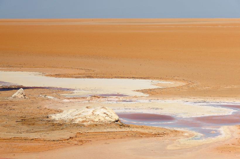
Chott el Jerid stretches like an immense white plain across southern Tunisia. For most of the year, it is dry and cracked, covered in a crust of shimmering white salt. In the rare rainy seasons, especially in winter, parts of it become a shallow lake, but it never fully fills. Its appearance constantly changes with light, weather, and heat, making it a magnet for photographers and travelers.
2. Name and Etymology
"Chott": From Arabic shat (شط), meaning "coast" or "bank," typically used for salt flats or seasonal lakes.
"Jerid": Refers to the nearby Jerid region of Tunisia, an area of oases and date palm cultivation, especially around Tozeur and Nefta.
3. Natural Phenomena and Appearance
Mirages: Due to extreme heat and flatness, the chott is famous for spectacular mirages. Visitors often see the illusion of lakes, trees, or buildings that vanish as they approach.
Salt Crust: The crust can be several centimeters thick and varies in color from brilliant white to reddish or brownish, depending on mineral content and light reflection.
Color Variations: The salt crust sometimes appears pink or green due to algae and minerals, especially in moist areas.
4. Climate and Conditions
Extreme heat: In summer, temperatures frequently exceed 50°C (122°F).
Low rainfall: Less than 100 mm per year, making it almost a true desert.
Evaporation: High evaporation rates prevent the chott from retaining water for long, even after rains.
5. Ecological Significance
Though harsh, Chott el Jerid is not devoid of life:
Migratory birds: Occasionally, flamingos and other waterfowl are spotted when there is water in the basin.
Desert flora and fauna: On the outskirts, you might find halophytes (salt-tolerant plants), desert foxes, and reptiles.
6. Historical and Mythological Importance
Roman Records: The Romans knew the area and considered it part of the frontier of the desert world.
Myths and Legends:
Believed to be the location of Urania, a legendary lost city swallowed by the sands.
Local Bedouin legends speak of spirits and mythical creatures haunting the salt flats.
Trade Routes: In ancient and medieval times, caravans sometimes crossed the chott, though it was dangerous due to mirages and quicksand-like terrain.
7. Modern Infrastructure
A major road (paved and maintained) crosses Chott el Jerid between Tozeur and Kebili, making the crossing possible for vehicles year-round.
This road is lined with viewpoints and photo stops, allowing visitors to explore the flat expanses without entering the more treacherous salt zones.
Salt harvesting is minimal but present in some areas.
8. Filming Location
Chott el Jerid gained global fame when it was used as a filming location for Star Wars:
In Star Wars Episode IV: A New Hope, it was the setting for Luke Skywalker’s home on Tatooine.
The Lars homestead set still exists and is accessible just off the main road, attracting Star Wars fans and photographers from around the world.
9. Tourism Experience
Best Time to Visit: Winter or early spring (November to March), when temperatures are bearable and some water may be present in the basin.
Activities:
Photography and sightseeing along the road crossing
Sunset views that turn the salt flats into shimmering mirrors
Off-road excursions and 4x4 tours arranged by local guides
Star Wars tour stops
10. Nearby Towns and Access Points
Tozeur (northeast): Famous for its palm oases, mudbrick architecture, and tourism infrastructure.
Kebili (southwest): A traditional Saharan town with proximity to other desert attractions like Douz and Matmata.
Douz (further south): Known as a gateway to deeper Sahara adventures.
Nefta: Smaller than Tozeur but with important cultural sites.
These towns offer accommodation, guides, and transport options for those wanting to visit the chott.
Summary
Chott el Jerid is a place of visual wonder and geographic significance. Its stark, dreamlike landscape challenges the senses with illusions, vast silence, and surreal beauty. It’s not just a natural phenomenon but a bridge between ecological extremes, ancient legends, and modern pop culture. Whether you're a photographer, a nature lover, or a film buff, Chott el Jerid offers a uniquely powerful and humbling experience in the heart of the Tunisian desert.

