Information
City: AndrosCountry: Greece
Continent: Europe
Andros, Greece, Europe
Andros is the northernmost island of the Cyclades and the second largest in the archipelago. Unlike the arid landscape typical of the Cyclades, Andros is defined by high mountains, abundant surface water, and lush valleys, earning it the nickname "The Island of Waters."
Historical Timeline
Antiquity: Inhabited since the Mycenaean era. In the 7th century BC, it became a significant naval power and established colonies in Thrace and Chalcidice.
Venetian Rule (1207–1566): Following the Fourth Crusade, the island was granted to the Marino Dandolo family. The Venetians built the Kastro (Lower Castle) and fortified the interior to protect against pirate raids.
The Shipping Era (19th–20th Century): Andros became a global maritime superpower. Wealthy shipowning families (such as the Embirikos and Goulandris) funded the island's neoclassical architecture and significant cultural institutions.
Urban Layout & Districts
Chora (Andros Town): Built on a narrow peninsula. It is a mix of neoclassical mansions and Cycladic stone houses. The main pedestrian street is paved in marble and leads to the "Invisible Sailor" square.
Gavrio: The island's primary port on the west coast, serving as the commercial and transport hub.
Batsì: A cosmopolitan seaside village and the main tourist resort, centered around a natural bay.
Messaria & Menites: Inland villages located in fertile valleys, famous for their walnut trees, springs, and Byzantine churches.
Top Landmarks
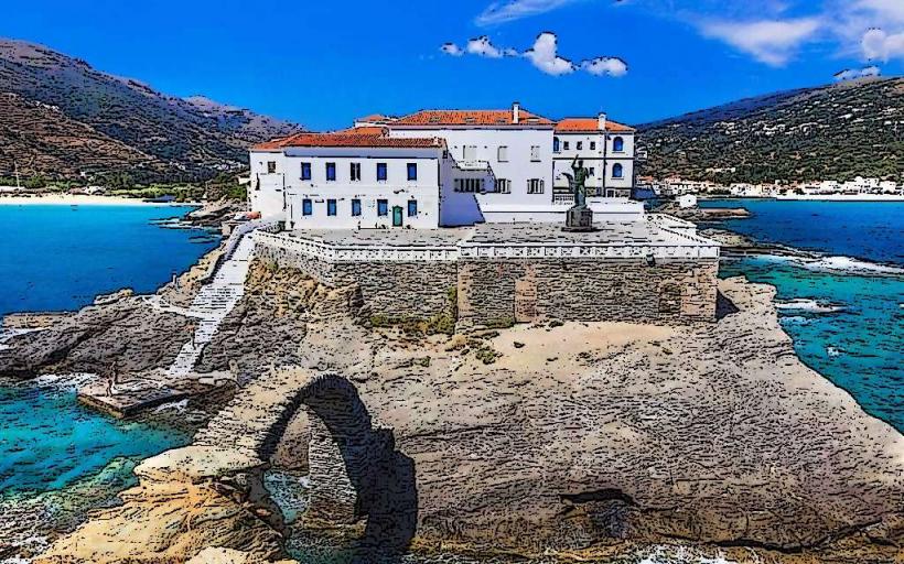
The Venetian Lower Castle (Kastro): Ruins of a 13th-century fortress located on an islet connected to Chora by a stone arched bridge.
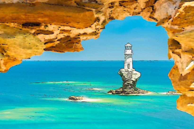
Tourlitis Lighthouse: Built on a solitary rock in the sea in front of Chora; it is the only lighthouse in Greece built entirely on a rock in the water.
Museum of Contemporary Art (Goulandris): A world-class museum in Chora that hosts international exhibitions of modern art.
Sariza Springs: Located in the village of Apoikia; famous for its mineral water which is bottled and distributed throughout Greece.
Stenies: The "Village of the Captains," known for its grand maritime villas and the "Fabrika" (an old pasta factory powered by water).
Transportation & Infrastructure (2026)
Sea: Access is primarily via Rafina (1–2 hours). There are no direct ferries from Piraeus.
Road: A well-maintained but winding mountainous road network. Cars or motorbikes are essential for exploring the interior.
Andros Routes: A certified network of over 180 km of ancient stone-paved hiking trails that connect villages, monasteries, and watermills.
Digital: 5G is stable in Chora, Gavrio, and Batsi. The "Andros Digital Guide" (2026) provides real-time GPS tracking for the hiking network.
Safety & Environment
Safety: Very safe with negligible crime.
Environment: The island contains several protected wetlands and the Pantanassa forest. In 2026, strict zoning laws protect the "water valleys" from over-development.
Wind: Like Tinos, Andros is subject to the northern Meltemi, making the northern beaches (Zorgos, Achla) difficult to access by boat during the summer.
Gastronomy & Local Products
Fourtalia: The signature dish of Andros; a thick omelet made with potatoes, local sausages, and fresh mint.
Amigdalota: Traditional almond-based sweets flavored with rosewater.
Petroti: A local cow's milk cheese pressed with stones to remove moisture.
Local Cost Index (2026)
1 Espresso (Freddo): €3.50–€4.50
1 Plate of Fourtalia: €12.00–€16.00
1 Ferry Ticket (Rafina-Andros): €25.00–€38.00
1 Standard Lunch: €18.00–€32.00
Facts & Legends
Legend says the island was named after Andros, the grandson of Apollo, who was a general for the Cretan King Minos. A verified historical fact: During the 19th century, the shipping fleet of Andros was so large that the island was considered the "Little England" of the Aegean, and it was the first Greek island to establish a modern maritime insurance company.