Information
City: BudaorsCountry: Hungary
Continent: Europe
Budaors, Hungary, Europe
Budaörs functions as the western gateway to the Budapest metropolitan area and the most economically significant town in Pest County. Situated in a specialized basin between the Buda Hills and the Tétény Plateau, it serves as the primary national hub for retail logistics, commercial headquarters, and high-tech warehousing. It is defined by its transition from a German-speaking agricultural village into Hungary’s "Commercial Capital," its unique dolomite "Bare Hills," and its possession of the busiest non-military airfield in the country.
Historical Timeline
Budaörs originated as a settlement of German colonists (Danube Swabians) invited after the Ottoman wars. The primary era of governance was characterized by the specialized cultivation of peaches and viticulture on the surrounding slopes. The primary event shaping its modern identity was the 1946 expulsion of the German population, followed by the late-1990s construction of the M1/M7 commercial corridor, which established the town as the logistics center for the nation.
Demographics & Population
The population is approximately 30,000. The demographic profile is characterized by a high-income, suburban population and a significant international business community. While predominantly Hungarian, the town maintains specialized German ethnic institutions and traditions.
Urban Layout & Key Districts
The city is structured by the sharp contrast between its historic residential core and the massive commercial strip.
Old Town (Ófalu): A specialized district at the foot of the hills, retaining its traditional Swabian architecture and the "Old Cemetery" memorial.
Commercial Zone: A specialized multi-kilometer strip along the M1/M7 motorways housing the national headquarters of major global retailers.
Frankhegy: A northern hilly district transitioning from holiday homes to high-end residential estates.
Kamaraerdő: A specialized green zone in the east, containing the city’s largest forest and recreational park.
Top City Landmarks
The Bare Hills (Kopárok): A specialized dolomite formation including Farkas-hegy and Kő-hegy, featuring unique flora and white limestone cliffs.
Budaörs Airfield: A specialized general aviation hub; historically the site of Hungary's first international airport and currently a center for sport flying.
Steinmetz House: A specialized local history museum documenting the Swabian heritage and the town's agricultural past.
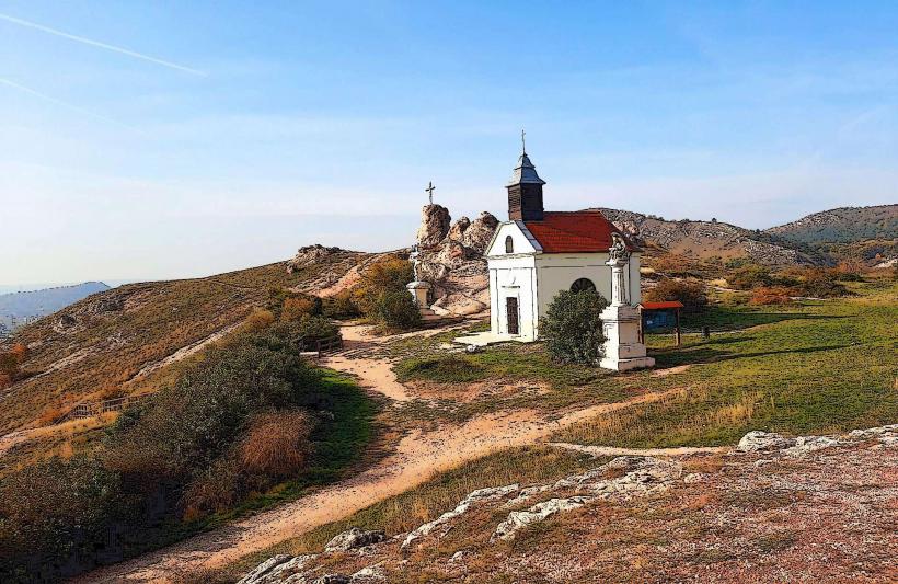
Mount Calvary (Kálvária-domb): A structural religious landmark on a small volcanic hill in the town center, offering a 360-degree urban view.
Nepomuki Szent János Church: The central Baroque parish church, serving as the landmark of the historic town core.
Transportation Network
Budaörs is the most critical road logistics node in Hungary.
M1/M7 Motorway Junction: The specialized "Western Gate" where the highways from Vienna and Lake Balaton merge before entering Budapest.
Budaörs Railway Station: Situated on the Budapest–Vienna main line, providing high-frequency suburban links to the capital.
Blue Bus Network: Fully integrated into the Budapest (BKK) transit system, with high-frequency specialized lines (e.g., 40, 40B, 240) connecting to the Metro 4 terminal.
Glider Port: The Farkas-hegy area is a specialized historical center for Hungarian gliding and aeronautical engineering research.
Safety & "Red Zones"
The general safety level is exceptionally high. Budaörs is statistically one of the safest municipalities in the Budapest agglomeration. There are no "red zones." Standard caution is advised for traffic congestion at the commercial strip during peak hours.
Digital & Financial Infrastructure
Budaörs is a leader in Retail Distribution and Corporate Management (housing the Hungarian HQs of firms like IKEA, Auchan, and Metro). Internet speeds average 500–1000 Mbps. 5G is universal and highly optimized for industrial use. Card and mobile payments are the absolute standard.
Climate & Air Quality
Budaörs has a temperate continental climate, often 1–2°C cooler than central Budapest due to the surrounding hills. Air quality is generally high, though the motorway corridor is subject to specialized noise and emission monitoring.
Culture & Social Norms
Social norms are characterized by a "prosperous suburban" lifestyle and a strong commitment to local German traditions. Tipping (10%) is expected. The primary cultural event is the Budaörs Festival and the Swabian Ball.
Local Cost Index
1 Espresso: 700 HUF (€1.80)
1 Pint of Beer: 900–1,400 HUF (€2.30–€3.60)
1 Standard Lunch: 4,200–6,500 HUF (€10.70–€16.60)
Nearby Day Trips
Budapest (District XI): 10 mins away; the nearest urban hub for museums and nightlife.
Biatorbágy Viaduct: 10 mins away; a specialized structural railway monument and site of the 1931 assassination attempt.
Budakeszi Wildlife Park: 15 mins away; a specialized center for indigenous Hungarian fauna.
Facts & Legends
Budaörs is the site of the "King's Skirmish" (1921), where the last Habsburg King, Charles IV, made his final unsuccessful attempt to reclaim the Hungarian throne. Legend states that the "Bare Hills" became treeless because the local Swabians grazed so many sheep there that the soil washed away, exposing the white dolomite. A verified fact is that Budaörs has the highest per capita tax revenue in Hungary due to its concentrated commercial sector. Historically, the town was the primary producer of the world-famous "Budaörsi Őszibarack" (Budaörs Peach).