Information
City: IringaCountry: Tanzania
Continent: Africa
Iringa, Tanzania, Africa
Iringa is the capital of the Iringa Region in Tanzania’s Southern Highlands, situated at an elevation of 1,600 m on a cliff overlooking the Little Ruaha River. Known for its temperate climate and rich history of anti-colonial resistance, it serves as the primary gateway to Ruaha National Park, the largest national park in East Africa.
Historical Timeline
Iringa was founded in the 1890s by German colonial forces as a military bastion against the Hehe people. The Hehe, led by the legendary Chief Mkwawa, mounted one of the most successful resistances against German expansion, notably defeating a German column at the Battle of Lugalo in 1891. Mkwawa's headquarters were at nearby Kalenga, where he eventually committed suicide in 1898 to avoid capture. The town later became a British administrative center and a hub for highland agriculture.
Demographics & Population
The 2026 metropolitan population is approximately 112,000. The region is the ancestral home of the Hehe people, known for their distinct Bantu dialect and tradition of high-altitude farming. The city also hosts a significant community of NGO workers, researchers, and students, particularly from the University of Iringa (formerly Mkwawa University).
Urban Layout & Key Districts
City Center: Compact and walkable, centered around the historic market and colonial administrative buildings.
Gangilonga: A prestigious residential district named after the "talking stone" rock formation.
Wilolesi: A hilltop district offering panoramic views of the Little Ruaha valley.
Kihesa: A densely populated residential and commercial area extending along the main highway.
Kalenga: A historic village 15 km west, home to the Mkwawa Museum and the Hehe royal lineage.
Top Landmarks
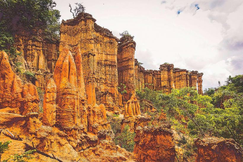
Isimila Stone Age Site: Located 20 km south; a spectacular archaeological site featuring Acheulean stone tools (up to 300,000 years old) and a dramatic canyon of naturally eroded sandstone pillars.
Iringa Boma: Built by the Germans in 1900, this fortified administrative building now serves as a regional museum and cultural center.
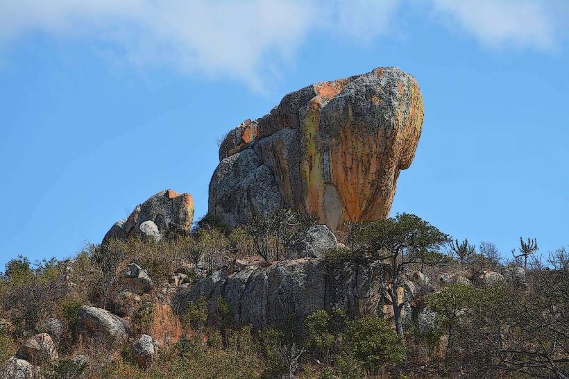
Gangilonga Rock: A massive granite outcrop where Chief Mkwawa is said to have meditated and met with his scouts.
Neema Crafts: A renowned social enterprise that provides training and employment for people with disabilities, featuring high-quality textiles, paper, and glass workshops.
Commonwealth War Cemetery: A meticulously maintained site containing the graves of soldiers from the WWI and WWII East African campaigns.
Ruaha National Park: Located 120 km west; a vast wilderness known for its massive elephant populations, rare antelopes (Sable and Roan), and a high concentration of lions.
Transportation Network
Air: Iringa Airport (IRI), also known as Nduli Airport, handles domestic flights to Dar es Salaam ($1.5$ hours).
Road: Located on the Tanzam Highway (A104). It is a major stop for buses traveling between Dar es Salaam ($8$–$9$ hours) and Mbeya ($5$–$6$ hours).
Local: Relies on Dala-dalas (minibuses), Bajajis (tuk-tuks), and Boda-bodas. The town's steep geography makes walking certain routes strenuous.
Safety & Health
Climate Dangers: Temperatures can drop significantly at night, especially from June to August ($5^\circ\text{C}$–$10^\circ\text{C}$). Warm clothing is essential.
Wildlife: While the city is safe, the road to Ruaha National Park passes through wildlife corridors; travelers should avoid night driving in these areas.
Health: Lower malaria risk than the coast, but precautions are still advised. The city has several reputable hospitals, including the Iringa Regional Referral Hospital.
Digital & Financial Infrastructure
5G is active in the city center and around the University of Iringa. The currency is the Tanzanian Shilling (TZS). Mobile Money (M-Pesa) is the standard for most transactions. ATMs are widely available in the CBD.
Climate & Economy
Subtropical highland climate ($Cwb$).
Weather: Cool and breezy year-round ($15^\circ\text{C}$–$25^\circ\text{C}$). The dry season runs from June to October.
Agriculture: The region is a major producer of maize, tobacco, and timber. Iringa is also famous for its high-quality Hehe baskets (Iringa baskets), woven from local milulu grass.
Local Cost Index (TZS)
1 Entry to Isimila Stone Age Site: 20,000–30,000 TZS (Non-Resident)
1 Traditional Hehe Basket (Medium): 15,000–25,000 TZS
1 Shared Dala-dala ride: 500–800 TZS
Facts & Legends
Legend says that the Gangilonga Rock would "speak" to Chief Mkwawa, warning him of German troop movements via the sounds of the wind through the stones. A geographic fact: Iringa is built on an escarpment that forms part of the Eastern Arc Mountains, an area of global biodiversity significance. Historically, the name Iringa is derived from the Hehe word lilinga, meaning "fortress."