Information
City: KalutaraCountry: Sri Lanka
Continent: Asia
Kalutara, Sri Lanka, Asia
Kalutara is a major coastal city in the Kalutara District of the Western Province, located 43 km south of Colombo. It serves as a vital bridge between the commercial capital and the southern tourism belt, situated at the estuary of the Kalu Ganga (Black River).
Historical Timeline
Historically, Kalutara was a center for the spice trade, particularly cinnamon. It was fortified by the Portuguese in the 17th century, followed by Dutch and British colonial administrations. The city is famous for its role as a religious sanctuary; it was once the site of a colonial fort that was later demolished to make way for the Kalutara Bodhiya, reclaiming the land for Buddhist worship.
Demographics & Population
The population is approximately 40,000. The demographic is predominantly Sinhalese Buddhist, with a significant Moor community. The economy is driven by rubber and coconut plantations, traditional basket weaving, and maritime industries.
Urban Layout & Key Districts
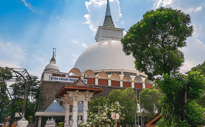
The Bridge Area: The primary landmark where the A2 highway crosses the Kalu Ganga; it is dominated by the white dome of the Kalutara Chaitya.
Kalutara North: A quieter residential area with several beachfront resorts.
Kalutara South: The commercial heart of the city containing the main railway station, markets, and administrative offices.
Katukurunda: A southern suburb known for its airfield and coastal scenery.
Top Landmarks
Kalutara Bodhiya: One of the most sacred Buddhist sites in Sri Lanka, featuring a Bo tree that is one of the 32 saplings of the Jaya Sri Maha Bodhi.
Kalutara Chaitya: A massive, hollow dagoba (the first of its kind in the world) allowing visitors to enter and view 74 murals depicting the life of the Buddha.
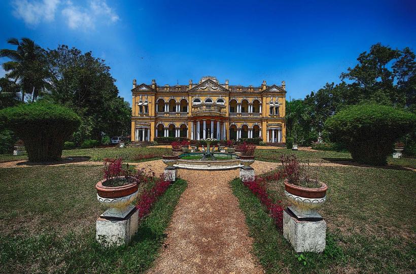
Richmond Castle: A two-story Edwardian mansion built in 1910, featuring a blend of British and Indian architectural styles set in a 42-acre estate.
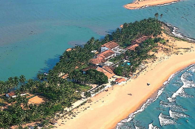
Calido Beach: A thin strip of land between the Kalu Ganga and the Indian Ocean, popular for sunset viewing.
Holy Cross Church: A prominent Catholic landmark reflecting the city's colonial religious heritage.
Transportation Network
Road: Accessible via the A2 coastal road or the E01 Southern Expressway (exit at Dodangoda).
Rail: Served by the Kalutara North and Kalutara South stations on the Coastal Line.
Public Transit: Frequent bus services connect Kalutara to Colombo (1 hour) and Galle (1.5–2 hours).
Local Transit: Tuk-tuks are the standard mode of transport. App-based services (PickMe/Uber) are generally available.
Safety & "Red Zones"
River Safety: The Kalu Ganga has strong currents and deep sections near the estuary; swimming in the river is highly dangerous.
Traffic: The Kalutara bridge is a major bottleneck; pedestrians should use the designated walkways and exercise extreme caution when crossing the A2.
Ocean Safety: Calido Beach is prone to erosion and strong undertows; swimming is discouraged unless in designated resort areas.
Digital & Financial Infrastructure
4G/LTE and fiber coverage are robust. The currency is the Sri Lankan Rupee (LKR). ATMs from all major banks (Commercial Bank, Sampath, BOC) are concentrated in Kalutara South. Credit cards are accepted in resorts and larger retail outlets.
Climate & Air Quality
Tropical rainforest climate with high humidity and heavy rainfall during the monsoon. Air quality is good, though vehicle emissions are high along the A2 highway.
Culture & Social Norms
The city is deeply religious and serves as a traditional stopping point for travelers heading south.
The "Coin Tradition": It is a local custom for motorists to stop at the Kalutara Bodhiya and drop a coin into the collection boxes to ensure a safe journey.
Etiquette: Modest dress (shoulders and knees covered) is mandatory for entering the Kalutara Bodhiya and Chaitya.
Cuisine: Famous for Mangosteens (available seasonally between May and September) and traditional hand-woven cane products.
Local Cost Index (LKR)
1 Espresso: 500–800 LKR
1 Standard Lunch (Rice & Curry): 400–900 LKR
1 Tuk-Tuk Ride (within town): 250–450 LKR
Nearby Day Trips
Fa Hien Caves: 1 hour inland; one of the largest prehistoric caves in Asia.
Thudugala Ella: 30 minutes inland; a scenic waterfall located within a rubber estate.
Barberyn Island Lighthouse: 20 minutes south (Beruwala); a colonial lighthouse on a tropical island.
Facts & Legends
Legend says the hollow Chaitya was designed to allow the sacred Bo tree to be visible from within the structure, though it was eventually built adjacent to it. A geographic fact: The Kalu Ganga is the fourth-longest river in Sri Lanka and brings significant sediment to the coast, creating the unique geography of Calido Beach. Historically, the Dutch once used Kalutara as a primary defensive position to protect their cinnamon interests in the interior.