Information
City: SamarindaCountry: Indonesia
Continent: Asia
Samarinda, Indonesia, Asia
Samarinda is the capital of the East Kalimantan province, situated along the banks of the Mahakam River. It is the most populous city on the island of Borneo and serves as a major hub for the coal, timber, and oil industries.
Historical Timeline
The city was founded in 1668 by a group of Bugis settlers from South Sulawesi who fled their homeland following the Treaty of Bongaya. They established a settlement on the riverbank that eventually grew into a vital trading post. During the 20th century, Samarinda transformed from a riverside village into an industrial powerhouse, largely due to its strategic position as the gateway to the resource-rich interior of Kalimantan.
Demographics & Population
The population is approximately 860,000. The demographic is a diverse mix of Bugis, Javanese, Banjarese, and indigenous Dayak peoples. The economy is heavily reliant on the extraction and export of natural resources, particularly coal, alongside a growing service sector.
Urban Layout & Key Districts
City Center: Located on the northern bank of the Mahakam River, featuring the main commercial strips and government offices.
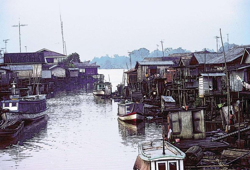
Samarinda Seberang: The historic southern bank where the original Bugis settlers established the city.
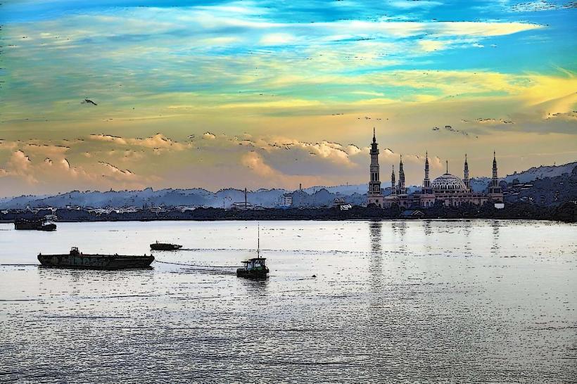
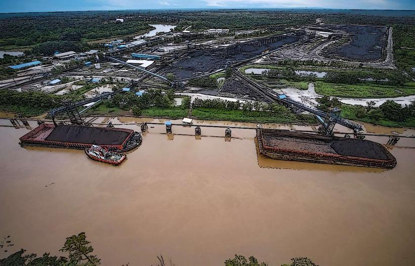
The Riverfront: The primary logistical artery, constantly busy with coal barges and passenger boats.
Palaran: A southern industrial district housing the city’s modern container terminal.
Top Landmarks
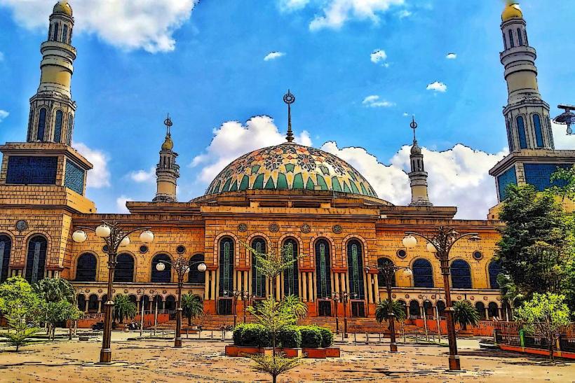
Samarinda Islamic Center Mosque: One of the largest mosques in Southeast Asia, featuring seven minarets and a prominent position on the riverbank.
Mahakam Bridge: The iconic suspension bridge connecting the two halves of the city.
Pampang Cultural Village: A Dayak Kenyah settlement where traditional dances and longhouse architecture are preserved.
Citra Niaga: An award-winning urban commercial space known for its traditional architecture and local souvenir shops.
Mahakam River Cruises: Boats depart from the city center to observe the rare Irrawaddy dolphins (Pesut Mahakam) upstream.
Transportation Network
Air: Apt Pranoto International Airport (AAP) connects the city to Jakarta, Surabaya, and other regional hubs.
Road: Directly connected to Balikpapan via the Balikpapan–Samarinda Toll Road, reducing travel time to approx. 1.5 hours.
River: The Mahakam River remains a vital highway for both heavy industrial cargo and long-distance passenger ferries to the interior.
Local Transit: Gojek and Grab are the primary modes of transport. Local Angkot (minibuses) serve established routes.
Safety & "Red Zones"
Flooding: Samarinda is highly prone to seasonal flooding due to its low-lying position and upstream deforestation; avoid the city center during heavy monsoon rains.
Industrial Traffic: The Mahakam River is congested with massive coal barges; small boat travelers must exercise extreme caution.
Air Quality: Periodic haze from peatland fires can occur during the dry season (August–October).
Digital & Financial Infrastructure
4G/5G coverage is excellent in the urban core. The currency is the Indonesian Rupiah (IDR). ATMs are ubiquitous. QRIS is widely used in modern malls like Big Mall Samarinda.
Climate & Air Quality
Tropical rainforest climate. It is hot and exceptionally humid year-round. Air quality is moderate, though it can be affected by industrial emissions and dust from coal transport.
Culture & Social Norms
River Life: Much of the city’s social and economic identity is tied to the Mahakam River.
Sarung Samarinda: The city is world-famous for its hand-woven silk sarongs, a tradition brought by the original Bugis settlers.
Cuisine: Famous for Amplang (fish crackers), Nasi Kuning, and various freshwater fish dishes like Patin and Jelawat.
Local Cost Index (IDR)
1 Espresso: 25,000–45,000 IDR
1 Standard Lunch (Nasi Kuning): 15,000–30,000 IDR
1 Short Taxi Ride: 35,000–55,000 IDR
Nearby Day Trips
Balikpapan: A cleaner, coastal city known for its beaches and malls.
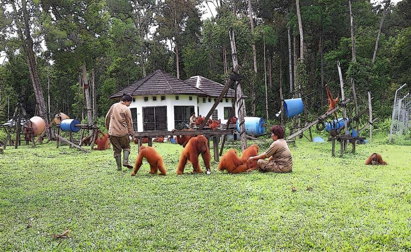
Samboja Lestari: An orangutan and sun bear rehabilitation center located between Samarinda and Balikpapan.
Facts & Legends
Legend says the name "Samarinda" comes from the Bugis words Sama and Rendah (equally low), referring to the settlers' houses being built at the same height as the local leader's house out of respect and equality. A geographic fact: Samarinda is a key support city for Nusantara (IKN), the new capital of Indonesia currently under construction to the southwest. Historically, the city’s growth was accelerated by the 1970s timber boom, which made it one of the wealthiest cities in Indonesia at the time.