Information
Landmark: Djurdjura MountainsCity: Blida
Country: Algeria
Continent: Africa
Djurdjura Mountains, Blida, Algeria, Africa
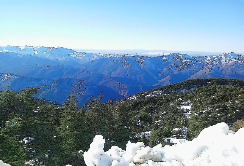
The Djurdjura Mountains are a mountain range located in northern Algeria, forming part of the Tell Atlas chain. They extend across the provinces of Bouira, Tizi Ouzou, and M'Sila.
Visual Characteristics
The Djurdjura Mountains are characterized by rugged limestone peaks, with elevations reaching over 2,300 meters (7,500 feet). The slopes are covered with dense forests of cedar, pine, and oak, transitioning to alpine meadows at higher altitudes. Snowfall is common during winter months, capping the highest summits.
Location & Access Logistics
The Djurdjura Mountains are situated approximately 100 kilometers (62 miles) southeast of Algiers. Access is primarily via the A1 motorway, exiting at designated points for mountain towns like Tikjda or Azazga. Local roads provide further access to trailheads and villages. Parking is available at designated visitor centers and some trailheads, though it can be limited during peak seasons. Public transport options are scarce; bus services connect major towns to the foothills, requiring onward travel by taxi or private vehicle.
Historical & Ecological Origin
The Djurdjura Mountains are geologically formed from Mesozoic limestone deposits, shaped by millions of years of erosion and tectonic activity. Ecologically, they represent a significant biodiversity hotspot within the Mediterranean region, supporting a variety of flora and fauna, including the endangered Barbary macaque.
Key Highlights & Activities
Hiking is a primary activity, with marked trails ranging from easy walks to challenging ascents. Skiing is possible at the Tikjda resort during winter. Rock climbing opportunities exist on specific limestone formations. Wildlife observation, particularly of birds and mammals, is also a focus for visitors.
Infrastructure & Amenities
Basic infrastructure is present in tourist areas like Tikjda, including a hotel, restaurants, and some restroom facilities. Cell phone signal (4G) is generally available in populated areas and at higher elevations, but can be intermittent in remote valleys. Food vendors are limited to established restaurants or small shops in nearby villages.
Best Time to Visit
The best months for hiking are from April to October, avoiding the winter snow and extreme summer heat. For photography, early morning and late afternoon light offers optimal illumination of the landscape. Skiing season typically runs from December to March, dependent on snowfall.
Facts & Legends
The Djurdjura Mountains are home to the legend of the "Djurdjura Women," a mythical group of female warriors said to inhabit the peaks. Historically, the mountains served as a refuge during various periods of conflict in Algeria.
Nearby Landmarks
- Djemaa el-Djazaïr (Great Mosque of Algiers) - 95km Northwest
- Tipasa Archaeological Park - 130km West
- Chrea National Park - 110km West
- Kalaat Beni Hammad - 150km South