Information
Landmark: Eo Gio CliffCity: Quy Nhon
Country: Vietnam
Continent: Asia
Eo Gio Cliff, Quy Nhon, Vietnam, Asia
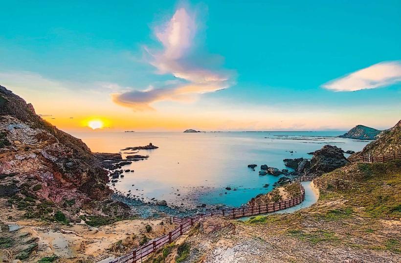
Eo Gio Cliff is a coastal rock formation located in Nhon Ly commune, Phu Cat district, approximately 20 kilometers northeast of Quy Nhon city, Binh Dinh province, Vietnam.
Visual Characteristics
The cliff face is composed of layered sedimentary rock, exhibiting shades of grey and brown. The rock formations are characterized by numerous sea caves and natural arches carved by wave action. The coastline features a narrow strip of sand and pebbles at the base of the cliff. Vegetation is sparse, consisting primarily of low-lying scrub and grasses adapted to the coastal environment.
Location & Access Logistics
Access to Eo Gio Cliff is via National Route 19B, then turning onto provincial road DT639 towards Nhon Ly. The site is approximately 20 kilometers from Quy Nhon city center, with a travel time of about 30-40 minutes by car. Parking is available at designated areas near the entrance, with a small fee. Public transport options are limited; local buses to Nhon Ly commune are available, requiring a subsequent taxi or motorbike taxi to the cliff site.
Historical & Ecological Origin
Eo Gio Cliff is a natural geological formation, primarily shaped by the erosive forces of the sea over millennia. The rock layers are indicative of ancient marine sedimentary deposits. Ecologically, it represents a coastal zone with specific flora and fauna adapted to saline conditions and wave exposure.
Key Highlights & Activities
Walking the designated pathway along the cliff edge provides views of the rock formations and the sea. Observation points are situated at intervals. Swimming is not recommended due to strong currents and submerged rocks. Photography is a primary activity, particularly during sunrise and sunset.
Infrastructure & Amenities
Restrooms are available at the entrance area. Limited shade is provided by natural rock overhangs and a few small shelters. Cell phone signal (4G) is generally available. Food vendors are present near the parking area, offering local snacks and beverages.
Best Time to Visit
The best time of day for photography is during the golden hours, approximately one hour after sunrise and one hour before sunset, when the light is softer and casts longer shadows. The dry season, from March to August, offers the most stable weather conditions. Tidal conditions do not significantly impact access to the main viewing areas.
Facts & Legends
Local folklore suggests that the sea caves within Eo Gio Cliff were once used as hiding places by fishermen during storms. A specific geological feature is the "Windy Pass" (Eo Gio), a narrow channel between rock formations where wind often funnels through, creating a distinct sound.
Nearby Landmarks
- Ky Co Beach (0.8km Southeast)
- Nhon Ly Village (2.5km West)
- Phuong Mai Peninsula (4.0km Southwest)
- Ghenh Rang Tien Sa Ecological Tourist Area (18.0km Southwest)