Information
City: BatnaCountry: Algeria
Continent: Africa
Batna, Algeria, Africa
Batna functions as the primary administrative and historical pivot of the Aurès region in eastern Algeria. Situated at an altitude of 1,048 meters, it serves as a specialized node for high-altitude agriculture, aerospace education, and archaeological tourism. In January 2026, the city is defined by a state of monumental infrastructure integration as it operationalizes new solar energy assets and finalizes key links in the national rail network.
Historical Timeline
1844: Founded as a French military encampment; specialized as a strategic garrison to control access between the Atlas Mountains and the Sahara.
1954 (Nov 1): The Algerian Revolution was officially proclaimed and launched in the Batna region under the leadership of Mustapha Benboulaïd.
2026 (Jan 13): Technical Hub Expansion. Batna began integration with the new Regional Directorate for Space Communications (Constantine), enhancing its specialized aerospace research capabilities.
2026 (Jan 18): National Rail Milestone. The government confirmed the 2026 delivery of the final segments of the 1,046km Hauts Plateaux rail line, which uses Batna as a primary east-west logistical junction.
2026 (Jan 22): Energy Diversification. Construction entered the final phase for Batna's portion of the 15,000 MW national solar program, establishing the province as a specialized node for renewable energy production.
Demographics & Population
The metropolitan population is approximately 365,000 (2026 estimate), reflecting a 1.96% annual growth. The demographic is characterized by a high density of Chaoui Berber heritage, influencing the city’s linguistic profile and cultural traditions. In 2026, Batna remains the fifth-largest city in Algeria and a primary center for higher education in the east.
Urban Layout & Key Districts
Downtown (Allées Benboulaïd): The specialized commercial and social core; characterized by wide promenades, administrative buildings, and the city’s primary retail density.
The "STAND" Area: A specialized modern district; home to the city’s upscale dining and the primary node for social activity during the summer and festival seasons.
University District: A specialized intellectual hub; contains the University of Batna 1 (Hadj Lakhdar) and University of Batna 2 (Mostafa Ben Boulaid).
Industrial Zone: Concentrated on the city’s periphery; focused on textile manufacturing, leather works, and specialized chemical processing.
Hamla 1 & 2: High-density new residential growth nodes to the west, housing a significant portion of the city's expanding middle class.
Top City Landmarks
Great Mosque of 1st November 1954: A specialized architectural landmark; one of the largest mosques in Algeria, symbolizing the city's revolutionary history.
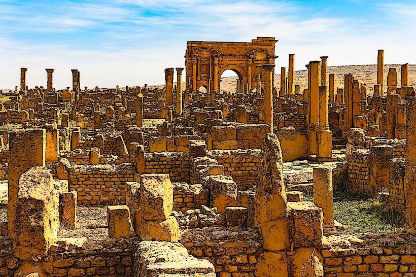
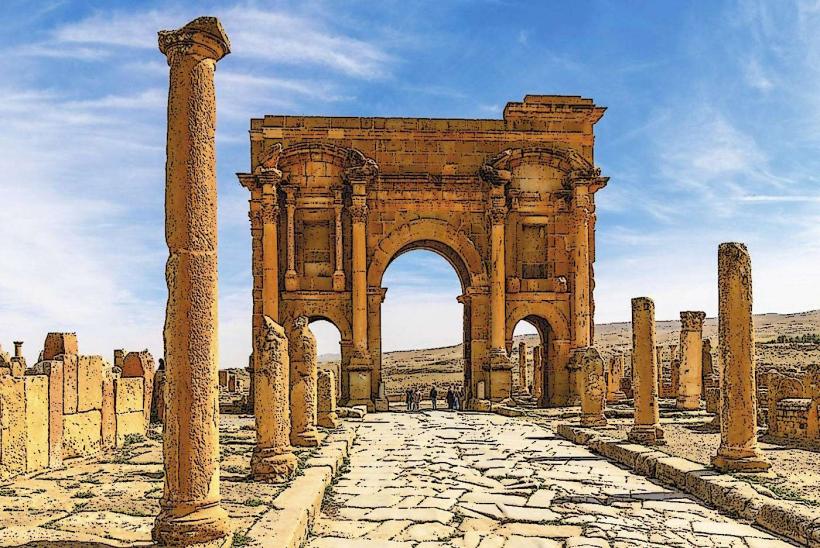
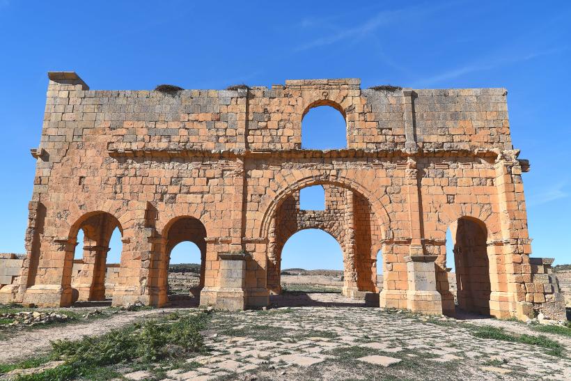
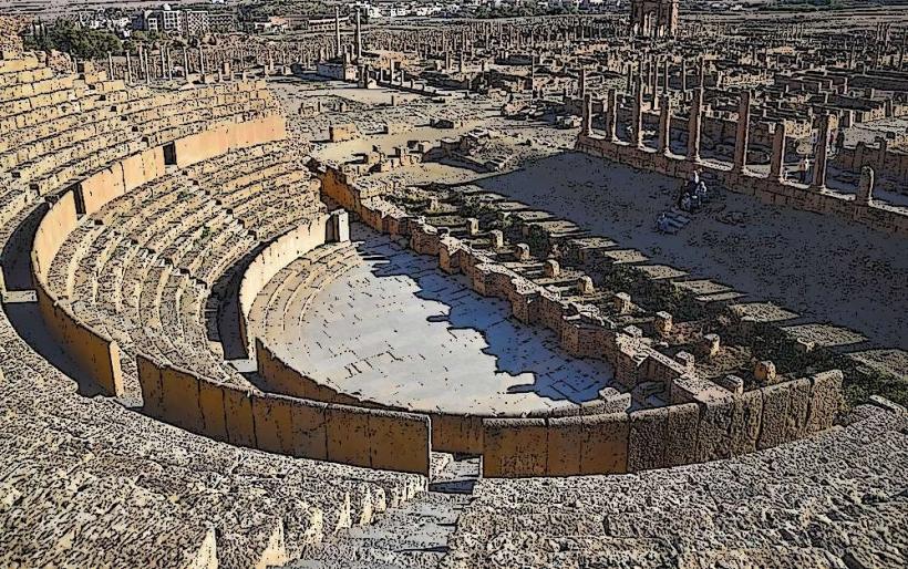
Timgad (Thamugadi): Located 35km east; a specialized UNESCO World Heritage site featuring an exceptionally well-preserved Roman grid-plan city.
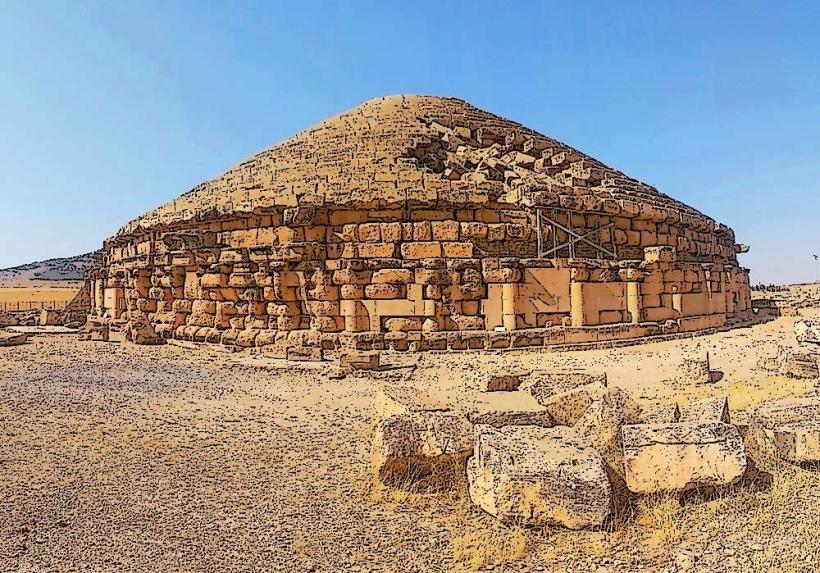
Medracen: A specialized 3rd-century BC Numidian royal tomb; the oldest circular pyramid-style mausoleum in the Maghreb.
Ghoufi Balconies: A specialized natural and archaeological canyon 90km south; features ancient troglodyte dwellings carved into spectacular geological strata.
Belezma National Park: A specialized biosphere reserve; protects high-density Atlas Cedar forests and provides the city's primary high-altitude recreational outlet.
Transportation & 2026 Logistics
Hauts Plateaux Railway: In early 2026, the SNTF began operational trials for the finalized sections of this 1,046km corridor, streamlining freight and passenger flow between Batna, Sétif, and Tebessa.
Mostépha Ben Boulaid Airport (BLJ): A specialized domestic and international gateway; currently integrating digital upgrades to support the city's growing role in the regional space communications network.
Aurès Aviation: A specialized flight school located at the airport; functions as the primary node for civil aviation training in eastern Algeria.
Road Network: Batna serves as the "Gateway to the Sahara," anchoring the intersection of the N3 and N31 highways.
Safety & Environment
The general safety level is High. Warning: As of January 2026, the city is managing specialized winter weather protocols; high-altitude mountain passes in the Aurès can be subject to sudden snowfall and ice. Environmental Note: The "Batna Solar Node" is currently the province's highest-priority environmental asset, aimed at reducing the city's carbon footprint by 15% by 2030.
Local Cost Index (2026 Estimates)
1 Night (Secure Business Hotel): DZD 7,500 – 13,000 (~$55 – $95)
Traditional "Couscous Chaoui" Meal: DZD 600 – 1,100
Monthly Public Transport Pass (Bus): DZD 1,600 – 2,400
Median Weekly Rent (1-BR Apartment): DZD 18,000 – 30,000
1L Gasoline: DZD 45.00
Facts & Legends
Batna is the site of the "Legend of the Lion of the Aurès," a title bestowed upon Mustapha Benboulaïd for his role in initiating the 1954 revolution. A verified fact is that Batna was the first city in Algeria where the declaration of the revolution was distributed. Historically, the city’s name is derived from the Arabic batn (belly), referring to its location in a sheltered valley between mountains. In 2026, the city remains the specialized global epicenter for "Numidian Archaeology," as local universities host the annual January symposium on the preservation of the Medracen mausoleum.