Information
City: ChelseaCountry: USA Massachusetts
Continent: North America
Chelsea, USA Massachusetts, North America
Chelsea is an independent city in Suffolk County, situated on a peninsula directly across the Mystic River from Boston. It is the smallest city in Massachusetts by land area (approximately 5.7 square kilometers) but one of the most densely populated, defined by its historic role as an industrial gateway and its modern status as a vital logistics and culinary hub for the Greater Boston area.
Historical Timeline
Inhabited by the Massachusett people for millennia. Primary governance eras include its 1624 founding as Winnisimmet and its 1857 incorporation as a city. A critical historical event was the Battle of Chelsea Creek (1775), the first naval engagement of the American Revolution. In the 20th century, Chelsea became a major center for the Jewish diaspora, often called the "Jerusalem of America." The city was twice devastated by massive fires (1908 and 1973) that fundamentally reshaped its urban landscape. The 21st century has been characterized by its emergence as a major "majority-minority" city and a center for regional food distribution.
Demographics & Population
The population is approximately 40,000. The demographics are Hispanic or Latino (67%), White (20%), Black or African American (6%), and Asian (3%). It is a high-density, working-class community with a massive immigrant population and a significant number of residents employed in the service and logistics sectors of Boston.
Urban Layout & Key Districts
Chelsea is characterized by intense urban density and industrial-residential integration.
Bellingham Square: The civic and commercial heart, featuring historic architecture, city hall, and the primary transit hub.
Admiral’s Hill: An affluent residential enclave located on a high point overlooking the Mystic River, site of a former naval hospital.
The Waterfront: A heavy industrial zone dominated by the New England Produce Center and various maritime logistics facilities.
Box District: A rapidly redeveloping area named for its history of box manufacturing, now featuring high-density transit-oriented housing.
Prattville: A predominantly residential neighborhood on the northwestern edge bordering Everett and Revere.
Top City Landmarks
New England Produce Center: One of the largest wholesale produce markets in the world, supplying most of New England's fresh food.
Mary O’Malley State Park: A scenic waterfront park at Admiral’s Hill offering views of the Boston skyline and the Tobin Bridge.
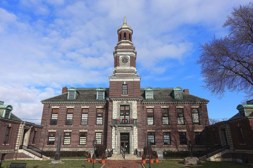
Chelsea City Hall: A grand 1910 structure inspired by the architecture of the Old State House in Boston.
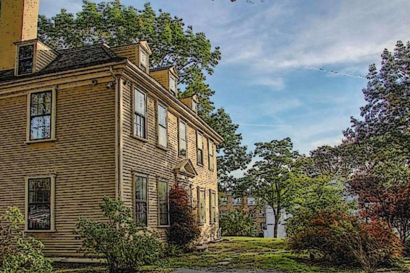
Governor Bellingham-Cary House: A 1659 hunting lodge that is one of the oldest standing structures in the United States.
The Tobin Bridge: While a piece of infrastructure, this massive cantilever bridge dominates the city’s skyline and connects it directly to Boston.
Apollinaire Theatre Company: A professional theater resident in the Chelsea Theatre Works, anchoring the city's small but vibrant arts scene.
Transportation Network
Movement is serviced by the MBTA Silver Line (SL3), providing rapid bus transit to South Station and Seaport, and the MBTA Commuter Rail (Newburyport/Rockport Line). The city is bisected by Route 1 (via the Tobin Bridge) and Route 16. Commercial air service is via Logan International (BOS), located less than 5 km to the southeast. Ride-sharing is universal. Traffic density is extreme, particularly on the Chelsea Curves and routes leading to the Tobin Bridge.
Safety & "Red Zones"
The general safety level is moderate to low. Chelsea historically reports crime rates higher than the Massachusetts average, particularly regarding narcotics activity and property crime. Caution is advised at night in parts of the Central Avenue corridor and specific blocks near Bellingham Square due to localized violent crime. There are no officially designated "red zones." Environmental hazards include high levels of noise and air pollution due to its proximity to Logan Airport and heavy truck traffic from the produce center.
Digital & Financial Infrastructure
Internet speeds average 500+ Mbps with fiber availability via Xfinity and Verizon Fios. Main mobile carriers are Verizon and T-Mobile. Card acceptance is universal in commercial hubs. ATMs are concentrated in Bellingham Square and at the Market Basket retail complex.
Climate & Air Quality
Temperatures range from -4°C to 3°C in winter and 18°C to 28°C in summer. The city's coastal position provides a slight moderating effect, but its high percentage of impervious surfaces creates a significant "urban heat island" effect in summer. Air quality is moderate to low, heavily impacted by jet fuel emissions from Logan and constant regional truck traffic.
Culture & Social Norms
The standard tipping percentage is 18–25%. A handshake is the standard greeting. Dress codes are "Urban-Pragmatic" or "Working-Class-Casual." The city is culturally defined by its "Chelsea Pride" resilience, its status as a sanctuary for new immigrants, and its world-class Latin American cuisine (specifically Salvadoran and Guatemalan).
Accommodation Zones
Everett / Chelsea Border: Recommended for modern hotel chains with shuttle access to Logan Airport.
Admiral’s Hill: Recommended for short-term residential rentals with harbor views.
Local Cost Index
1 Espresso: $4.00 (USD)
1 Standard Lunch: $16.00 (USD)
1 MBTA Silver Line Fare: $2.40 (Single).
Nearby Day Trips
Boston: (Directly adjacent; accessible in minutes via bus or rail).
Revere Beach: (5 km northeast; the first public beach in the U.S.).
Encore Boston Harbor: (3 km west in Everett; luxury casino resort).
Facts & Legends
Chelsea is the most densely populated city in Massachusetts outside of Somerville. Historically, the city was the site of the first regional headquarters of the FBI. A local legend involves the "Ghost of the 1908 Fire," rumored spectral figures seen near the sites of the most intense devastation. Another legend concerns "The Sunken Fleet of Chelsea Creek," referring to colonial-era wreckage supposedly buried deep in the mud beneath the industrial docks.