Information
City: Gia LaiCountry: Vietnam
Continent: Asia
Gia Lai, Vietnam, Asia
Gia Lai serves as the northern gateway of the Central Highlands (Tay Nguyen) and is the second-largest province in Vietnam by land area. It functions as a strategic logistics hub for the Development Triangle of Vietnam, Laos, and Cambodia. Pleiku City acts as its administrative and economic center.
Historical Timeline
The region was historically the territory of the Jarai and Bahnar ethnic groups. During the French colonial era, it was developed for tea and coffee plantations. The most significant architectural and political shifts occurred during the Vietnam War, as Pleiku served as a major military base for the II Corps. The current urban form was largely defined by the post-war reconstruction of the 1980s and the 2020 upgrade of Pleiku to a Grade I provincial city, marking its transition into a modernized highland urban center.
Demographics & Population
The provincial population is approximately 1.6 million, with Pleiku housing roughly 260,000 residents. The demographic profile consists of the Kinh majority (approx. 55%), followed by the Jarai (30%) and Bahnar (12%). The median age is 28.2 years.
Urban Layout & Key Districts
Pleiku is built on a volcanic plateau, characterized by undulating terrain. Hoa Lu (Central) is the primary commercial and dining district. Tay Son (South) is the administrative core. Bien Ho (North) is the suburban tourism zone defined by the volcanic crater lake. The city’s layout is centered around the intersection of National Highway 14 and Highway 19.
Top City Landmarks
Bien Ho (T'Nung Lake): A massive freshwater lake situated in a dormant volcanic crater.
Pleiku Prison: A historical site from the French and American war eras.
Minh Thanh Pagoda: Notable for its Japanese-inspired architecture and 9-story stupa.
Gia Lai Provincial Museum: Focuses on ethnic minority artifacts and gong culture.
Victory Monument: Located at Dai Doan Ket Square.
Transportation Network
Movement is conducted via private motorbikes and local bus lines. Grab (Car and Bike) is operational and the most reliable method for short-distance travel. There is no metro or railway. Pleiku Airport (PXU) provides daily flights to Hanoi, Ho Chi Minh City, and Da Nang. Traffic density is low to moderate, but Highway 14 is a high-traffic corridor for heavy transit.
Safety & "Red Zones"
Gia Lai is categorized as very safe. There are no specific "red zones." Caution is advised when driving on the "Pha Din" style mountain passes on Highway 19 toward Quy Nhon due to fog and steep inclines. Visitors should avoid entering rubber or coffee plantations at night without a local guide due to the risk of disorientation.
Digital & Financial Infrastructure
Average internet speed is 64 Mbps. Main mobile carriers are Viettel, Vinaphone, and Mobifone. Card acceptance is high in Pleiku’s central hotels and cafes but non-existent in the "Plei" (ethnic villages). ATMs are concentrated around Dai Doan Ket Square and Hung Vuong Street.
Climate & Air Quality
Temperatures range from 14°C to 22°C in the cool season (December–January) and 22°C to 32°C in the dry season. Air quality is exceptionally high. The rainy season (May–November) is severe, often resulting in prolonged heavy mist and reduced visibility in Pleiku.
Culture & Social Norms
Tipping is not standard. Handshakes are the professional norm. Dress code is conservative; footwear must be removed before entering a Bahnar communal house (Nha Rong). A critical social norm is the adherence to Jarai and Bahnar funeral customs, which may involve elaborate "tomb abandonment" (Bo Ma) ceremonies; visitors should only observe from a distance unless invited.
Accommodation Zones
Pleiku Center (Hoa Lu Ward): Recommended for dining, nightlife, and proximity to major city landmarks.
Bien Ho Area: Recommended for a resort-style stay with higher air quality and lake views.
Local Cost Index
1 Espresso (Gia Lai Coffee): 20,000 VND ($0.85)
1 Standard Lunch (Dry Pho - Phở Khô): 45,000 VND ($1.85)
1 Taxi trip (3km): 45,000 VND ($1.85)
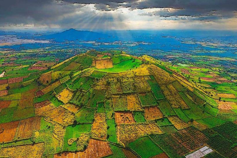
Nearby Day Trips
Chu Dang Ya Volcano: 30 km (45 minutes)
Phu Cuong Waterfall: 45 km (1 hour)
Yaly Hydropower Dam: 40 km (1 hour)
Kon Ka Kinh National Park: 50 km (1.5 hours)
Facts & Legends
A prominent local legend regarding T'Nung Lake (Bien Ho) suggests the lake is "bottomless" and connected to the East Sea via a subterranean tunnel, though it is scientifically verified as a volcanic crater approximately 30 meters deep. A verified historical oddity is the "Dry Pho" (Phở Khô Gia Lai), which is served in two separate bowls (one for noodles, one for broth)-a culinary norm unique to this province that dictates a specific mixing technique using fermented soy paste.