Information
City: Ha TinhCountry: Vietnam
Continent: Asia
Ha Tinh, Vietnam, Asia
Ha Tinh serves as a critical industrial and energy hub for North Central Vietnam, housing the nation's largest deep-water port and steel complex at Vung Ang. It is situated in the North Central Coast region, bordered by Nghe An to the north, Quang Binh to the south, and Laos to the west.
Historical Timeline
The region has been an administrative entity since the 10th century, historically known as a "cradle of scholars" due to its high concentration of literati. Formal governance shifted from the Nguyen Dynasty to French colonial rule in 1883. The most significant modern shift occurred on July 1, 2025, when Ha Tinh was officially merged into Nghe An Province as part of a national administrative consolidation. This merger created the largest provincial unit in Vietnam, integrating Ha Tinh’s heavy industrial capacity at Vung Ang with Nghe An’s political and educational infrastructure. The current urban form is defined by the expansion of the Vung Ang Economic Zone and the 2010s industrialization.
Demographics & Population
The population of the Ha Tinh area is approximately 1.3 million. The demographic is almost entirely Kinh (99%), with small groups of Muong and Lao near the western border. The region is noted for its high proportion of students and a strong culture of academic achievement. The median age is approximately 31.2 years.
Urban Layout & Key Districts
The area is organized between the coastal industrial zones and the western mountain ranges.
Ha Tinh Ward (Central): Formerly Ha Tinh City, it remains the primary residential and commercial hub of the southern district.
Ky Anh (South): A specialized industrial city housing the Formosa steel complex and Vung Ang Port.
Hong Linh (North): A logistics and transit town located at the base of the Hong Linh Mountains.
Vinh City (North): Following the 2025 merger, Vinh serves as the primary administrative headquarters for the unified province.
Top City Landmarks
Dong Loc Junction: A major historical site dedicated to the ten young female volunteers of the Vietnam War.
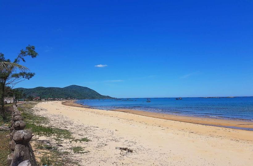
Thien Cam Beach: Known for its "Heaven's Lute" shape and clear waters.
Huong Tich Pagoda: Located on the Hong Linh Mountains, often called the "First Pagoda of the South."
Nguyen Du Memorial Site: Dedicated to the author of the national epic The Tale of Kieu.
Ke Go Lake: A massive irrigation reservoir and nature reserve.
Transportation Network
Movement relies on National Highway 1A and the North-South Expressway.
Road: Grab (Car/Bike) is operational in Ha Tinh Ward and Ky Anh. Official taxis are green (Mai Linh) or white (Taxi Ha Tinh).
Rail: The North-South railway services the Yen Xuan and Huong Pho stations.
Port: Vung Ang-Son Duong is a premier international deep-water port.
Connectivity: The 2024 completion of the North-South Expressway segments has reduced travel time to Hanoi to under 5 hours.
Safety & "Red Zones"
Ha Tinh is categorized as very safe for travelers. There are no designated "red zones." Caution is advised on Highway 1A near Ky Anh due to high-density container truck traffic. During the monsoon season (September–November), low-lying areas near Ke Go Lake are prone to rapid flooding.
Digital & Financial Infrastructure
Average internet speed is 65 Mbps. Following the 2025 merger, 5G coverage was expanded to cover the entire Vung Ang industrial corridor. Card acceptance is high in modern hotels and Vincom Plaza Ha Tinh but non-existent in local seafood markets. ATMs are concentrated along Phan Dinh Phung and Tran Fu streets.
Climate & Air Quality
Temperatures range from 14°C to 19°C in winter and 28°C to 38°C in summer. Air quality is moderate; localized particulate matter is higher in the Ky Anh industrial zone. The region is famously affected by the Lao Wind (hot, dry westerly winds) from May to July and severe typhoons in the autumn.
Culture & Social Norms
Tipping is not standard. Handshakes are the professional greeting. Dress code is strictly conservative at Dong Loc Junction and Huong Tich Pagoda. A unique social norm is the high value placed on Vi-Giam folk singing, a UNESCO-recognized intangible heritage that is deeply integrated into local social life and community festivals.
Accommodation Zones
Ha Tinh Ward Center: Recommended for logistical access, dining, and central landmarks.
Thien Cam Beach: Recommended for leisure and seasonal seafood tourism.
Local Cost Index
1 Espresso: 25,000 VND ($1.05)
1 Standard Lunch (Ram Muot): 40,000 VND ($1.65)
1 Taxi trip (3km): 50,000 VND ($2.05)
Nearby Day Trips
Vinh City: 50 km (1 hour)
Dong Loc Junction: 20 km (30 minutes)
Huong Tich Pagoda: 30 km (45 minutes)
Muong Thanh Safari: 60 km (1.2 hours)
Facts & Legends
A prominent local legend involves the Hong Linh Mountains, which are said to have 99 peaks; legend states that 100 phoenixes flew to the range, but because there were only 99 peaks, one bird flew away, and the rest followed. A verified historical oddity is that the Ke Go Lake inspired one of Vietnam's most famous socialist-era folk songs ("Guigui loi ca ke go"), which remains a cultural anthem for the province’s resilience in the face of nature. Another fact is that Ha Tinh is the birthplace of Nguyen Du, whose 3,254-line poem The Tale of Kieu is considered the most significant work in Vietnamese literature.