Information
City: RotumaCountry: Fiji
Continent: Australia
Rotuma, Fiji, Australia
Rotuma functions as a unique administrative dependency of Fiji, located approximately 465 kilometers north of the main archipelago. It is a volcanic island of 43 square kilometers, characterized by its distinct Polynesian culture and language, which separates it from the predominantly Melanesian-influenced regions of Viti Levu and Vanua Levu.
Historical Timeline
Rotuma was traditionally ruled by seven paramount chiefs representing its autonomous districts. It was first sighted by Europeans in 1791 (HMS Pandora). Following a period of internal religious conflict between Catholic and Protestant converts, the chiefs petitioned Great Britain for annexation. Rotuma was formally ceded to the British Crown on May 13, 1881-seven years after Fiji. Upon Fiji’s independence in 1970, Rotuma remained politically affiliated with the nation while maintaining a specialized "dependency" status.
Demographics & Population
The population on the island is approximately 1,600 residents. However, there is a massive diaspora, with over 10,000 Rotumans living in Fiji (primarily Suva and Lautoka) and abroad. The demographic is almost exclusively Rotuman, a Polynesian ethnic group with strong linguistic and ancestral ties to Tonga and Samoa. The median age on the island is approximately 28 years, though out-migration has created an "hourglass" demographic profile with high proportions of children and the elderly.
Urban Layout & Key Districts
Rotuma is divided into seven districts: Itu'ti'u, Itu'muta, Ju'pu, Losa, Malha'a, Noa'tau, and Oinafa.
Ahau (Itu'ti'u): Serves as the administrative center, housing the hospital, post office, and government station.
Oinafa: The location of the primary deep-water wharf and a secondary hub for maritime arrivals.
Malha'a: The logistical district containing the island’s airfield.
Top Landmarks
Mount Juju: An extinct volcanic peak offering panoramic views of the island’s interior.
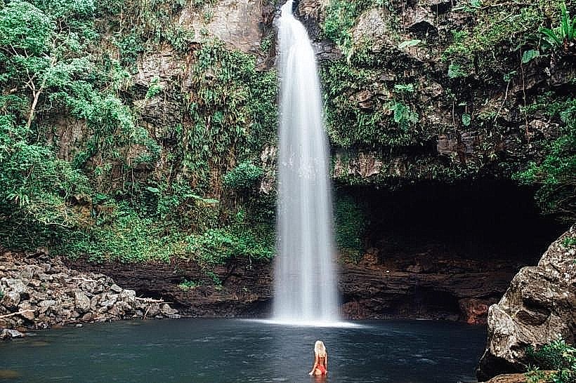
Hapmafau Falls: A seasonal natural landmark located on the southern coast.
Oinafa Wharf: A critical infrastructure site and the primary point of entry for cargo vessels.
St. Michael’s Catholic Church (Upu): A prominent stone church and historical site.
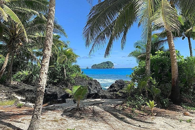
Maka Bay: Known for its volcanic rock formations and traditional fishing grounds.
Transportation Network
Movement is facilitated by a single unsealed perimeter road that circles the island. There is no public transit, metro, or organized ride-sharing. Transport relies on guesthouse-owned 4WD vehicles and a small number of private trucks used as communal taxis. Aviation access is via Fiji Link (typically once or twice weekly) to Rotuma Airport. Maritime transit involves a monthly government franchise ferry from Suva/Lautoka. Traffic density is non-existent.
Safety & "Red Zones"
The safety level is extremely high. Crime is practically non-existent due to the island's isolation and tight-knit communal structure. There are no "red zones." The primary risks are environmental: the fringing reef is dangerous for inexperienced swimmers, and the volcanic terrain can be unstable during heavy tropical rains.
Digital & Financial Infrastructure
Internet is extremely limited, with speeds often below 5 Mbps, delivered via satellite. Vodafone and Digicel maintain towers in Ahau and Malha'a, but 4G signal is inconsistent. The economy is strictly cash-based. There are no ATMs on Rotuma. All visitors must withdraw sufficient FJD cash in Nadi or Suva before departure. Credit cards are only accepted at the few established guesthouses via manual processing.
Climate & Air Quality
Rotuma has a tropical rainforest climate that is "oppressive" and consistently hot. Daytime temperatures vary minimally, typically staying between 26°C and 31°C year-round. Air quality is pristine. The island is outside the main Fiji cyclone path but still faces risks of storm surges and prolonged droughts due to its reliance on groundwater.
Culture & Social Norms
Rotuman culture is Polynesian and highly distinct from mainland Fiji. Tipping is not expected. The island follows a "Rotuma Time" social pace. Traditional etiquette is mandatory: hats must be removed in villages, and shoulders/knees must be covered. The Mamasa (dryness) ceremony is a unique tradition where visitors are formally welcomed with a garland and oiling. Consumption of alcohol is generally restricted to private residences or guesthouses.
Accommodation Zones
Itu'ti'u (Ahau/Motusa): Recommended for logistics and proximity to the few available government services.
Oinafa: Recommended for beach access and proximity to the wharf.
Accommodation is limited to small, family-run guesthouses; there are no large resorts.
Local Cost Index
1 Espresso: N/A (Instant coffee only)
1 Standard Lunch: 15.00–25.00 FJD ($6.70–$11.15 USD)
1 Round-island Truck Hire: 80.00–120.00 FJD ($35.70–$53.60 USD)
Nearby Day Trips
Hatana Island: An uninhabited islet off the western coast, considered sacred and home to the burial sites of legendary chiefs (accessible by boat, requires traditional permission).
Uea Island: A prominent volcanic islet to the north, notable for its steep cliffs and bird colonies.
Facts & Legends
Rotuman mythology begins with the legend of Raho, a Samoan chief who is said to have "formed" the island by emptying a basket of earth into the sea to escape a dispute in his homeland. A unique historical fact is that Rotumans are the only ethnic group in Fiji with their own specific Act of Parliament (the Rotuma Act), which governs land tenure and local administration. An urban legend persists that certain rocks on the island are actually the petrified remains of Raho’s original baskets.