Information
Landmark: Dinajpur-Rangpur BridgeCity: Rangpur
Country: Bangladesh
Continent: Asia
Dinajpur-Rangpur Bridge, Rangpur, Bangladesh, Asia
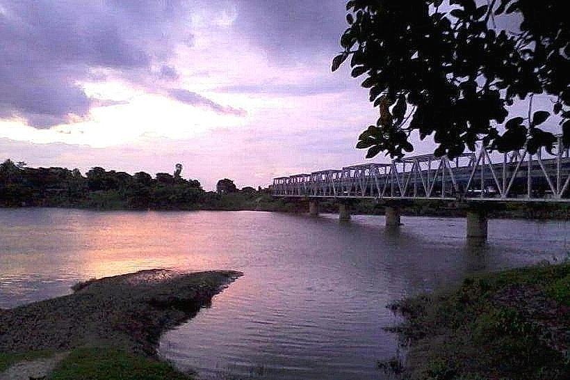
The Dinajpur-Rangpur Bridge is a significant transportation artery connecting the cities of Dinajpur and Rangpur in Bangladesh.
This bridge facilitates regional travel and commerce across the Teesta River.
Visual Characteristics
The bridge is a concrete structure with multiple spans. Its primary color is a utilitarian grey, typical of reinforced concrete construction. The deck is approximately 10 meters wide, accommodating two lanes of vehicular traffic. Support piers are spaced regularly along the river's course.
Location & Access Logistics
The bridge is situated approximately 15 kilometers west of Rangpur city center, directly on National Highway 1 (N1). Access from Rangpur is via N1 heading west. From Dinajpur, access is via N1 heading east. Ample paved shoulders provide temporary stopping points, but dedicated parking facilities are not present at the bridge itself. Public transport, including local buses and inter-city coaches, regularly traverse the bridge as part of their routes between Rangpur and Dinajpur.
Historical & Ecological Origin
Construction of the Dinajpur-Rangpur Bridge was completed in 1985. It was engineered by the Bangladesh Bridge Authority to improve connectivity and reduce travel times across the Teesta River, a major tributary of the Jamuna River. The bridge spans a section of the Teesta River characterized by alluvial deposits and moderate water flow, subject to seasonal variations.
Key Highlights & Activities
Observation of river traffic, including local fishing boats and larger cargo vessels, is possible from the bridge's pedestrian walkways. Photography of the river landscape during sunrise and sunset is feasible. The primary function remains transportation.
Infrastructure & Amenities
Pedestrian walkways are present on both sides of the bridge. There are no dedicated restroom facilities or shade structures directly on the bridge. Cell phone signal (4G) is generally available. Food vendors are typically located in the towns at either end of the bridge, not directly on it.
Best Time to Visit
For photography, the hours around sunrise (approximately 5:30 AM to 6:30 AM) and sunset (approximately 5:00 PM to 6:00 PM) offer optimal lighting conditions. The dry season, from November to March, generally provides clearer skies and more stable river conditions. There are no tide-related considerations for this river bridge.
Facts & Legends
A local anecdote suggests that the bridge's construction was expedited due to a perceived need to connect two historically significant market towns more efficiently, fostering economic exchange.
Nearby Landmarks
- Rangpur City Center (15km East)
- Teesta Barrage (30km North)
- Dinajpur Town Center (25km West)
- Kantajew Temple (20km Northwest)