Information
Landmark: Dnipro EmbankmentCity: Dnipro
Country: Ukraine
Continent: Europe
Dnipro Embankment, Dnipro, Ukraine, Europe
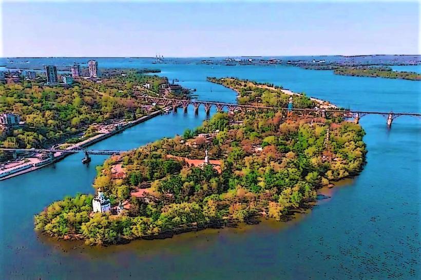
The Dnipro Embankment is a significant urban waterfront area situated along the Dnipro River in the city of Dnipro, Ukraine.
This extensive promenade serves as a primary recreational and transit corridor for the city's residents and visitors.
Visual Characteristics
The embankment is primarily paved with concrete and asphalt. Sections feature decorative stone tiling and metal railings. The width varies, with wider areas designated for pedestrian traffic and narrower sections adjacent to roadways. Green spaces with mature trees, primarily deciduous species, are integrated along its length. The river itself is wide, with a generally calm surface, reflecting the sky and surrounding urban structures. The opposite bank is visible across the water.
Location & Access Logistics
The Dnipro Embankment extends for approximately 10 kilometers along the right bank of the Dnipro River. It begins near the Amur Bridge in the east and continues westward towards the Dnipro Hydroelectric Power Plant. Access is available from numerous city streets, including Naberezhna Peremohy Street, which runs parallel to the embankment for much of its length. Public parking is available in designated lots and along adjacent streets, though availability can be limited during peak hours. Public transport options include trolleybus lines 1, 5, 7, 10, 12, 14, 16, 17, and 19, as well as numerous marshrutka (minibus) routes that stop along Naberezhna Peremohy Street.
Historical & Ecological Origin
The development of the Dnipro Embankment began in the mid-20th century as part of a larger urban planning initiative to manage the riverfront and create public spaces. Its construction was influenced by Soviet-era urban design principles, emphasizing grand promenades and recreational zones. The embankment's existence is intrinsically linked to the Dnipro River, a major European river flowing through Eastern Europe. The river's ecosystem supports various fish species and riparian vegetation along its banks.
Key Highlights & Activities
Walking and cycling are primary activities along the embankment. Several sections are designated as pedestrian-only zones. Boat tours of the Dnipro River depart from piers located along the embankment. Outdoor fitness equipment is installed in specific areas. Cafes and kiosks are present, offering refreshments. The embankment provides access points for fishing in the river.
Infrastructure & Amenities
Restrooms are available at intervals, particularly near major access points and recreational zones. Shaded areas are provided by mature trees and some covered seating structures. Cell phone signal (4G/5G) is generally strong throughout the embankment. Food vendors and cafes are located along the promenade and on adjacent streets.
Best Time to Visit
For photography, early morning or late afternoon offers favorable lighting conditions, with the sun rising or setting over the river. The best months for visiting are from May to September, when temperatures are mild and outdoor activities are most comfortable. High tide is not a significant factor for access or activity on the embankment itself.
Facts & Legends
A notable feature is the "Bridge of Lovers," a pedestrian bridge connecting the embankment to Monastyrsky Island, where local tradition suggests couples can secure their relationship by attaching a padlock to its railings.
Nearby Landmarks
- Monastyrsky Island (0.2km West)
- Dniprovskyi National University (1.5km North-West)
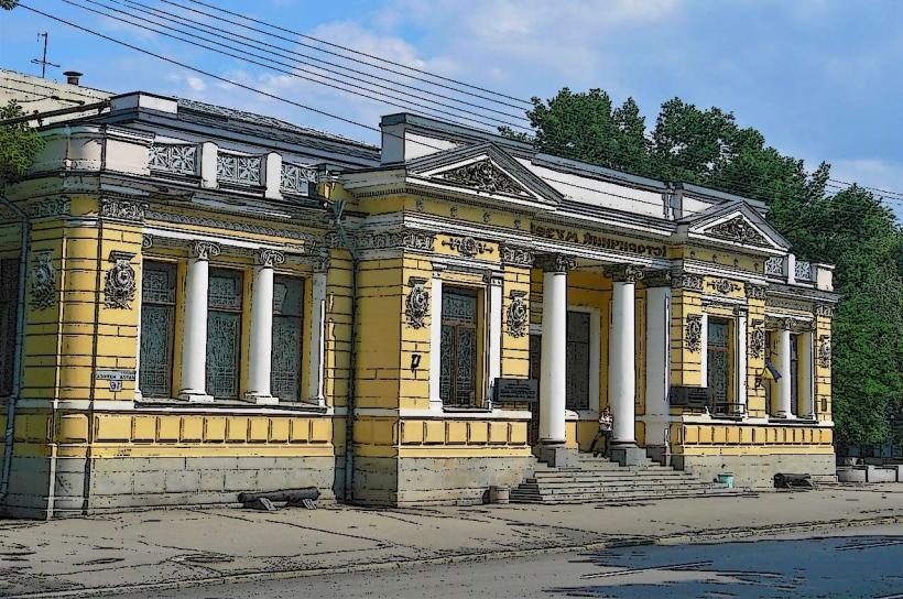
- Museum of Ukrainian History named after Dmytro Yavornytsky (1.8km North-West)
- Potemkin Palace (2.5km North-West)
- Shevchenko Park (2.8km North-West)