Information
Landmark: Dukagjin HighlandsCity: Puka
Country: Albania
Continent: Europe
Dukagjin Highlands, Puka, Albania, Europe
The Dukagjin Highlands (Malësia e Dukagjinit) is a mountainous ethnographic region located in the Shkodër District of northern Albania, not the Pukë District. It encompasses the rugged territory of the Shala, Shoshi, and Pulti valleys within the Albanian Alps (Prokletije), situated north of the Drin River.
Visual Characteristics
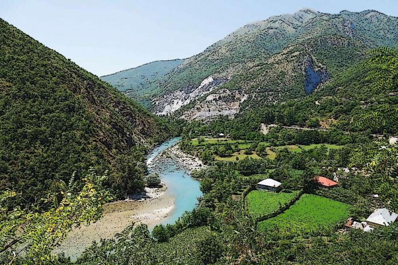
The terrain is defined by extreme vertical relief, featuring limestone massifs that rise to over 2,500 meters, such as Maja e Harapit. The landscape includes deep glacial U-shaped valleys, narrow karst canyons, and dense forests of beech and Bosnian pine. The riverbeds are characterized by white limestone boulders and high-transparency, turquoise water. Many slopes are marked by stone-walled terraces and traditional dry-stone architecture.
Location & Access Logistics
Access is primarily via the SH21 road from Shkodër, which leads to the Theth National Park via the Qafa e Thores pass (1,685m). The journey from Shkodër to the heart of the highlands takes approximately 2 to 3 hours. Another access point is via the Lake Koman ferry to the Shala River mouth. While the road to Theth is mostly paved, secondary tracks connecting villages like Kir and Prekal require high-clearance 4x4 vehicles. Public minibuses (furgons) depart daily from Shkodër to Theth and Shala.
Historical & Ecological Origin
The region is named after the Dukagjini family, a prominent medieval Albanian noble house. It is the birthplace of the Kanun of Lekë Dukagjini, the traditional code of oral laws that governed Northern Albanian life for centuries. Geologically, the highlands were formed by the tectonic uplift of the Dinarides and shaped by significant Quaternary glaciation. The area is part of the Alps of Albania National Park.
Key Highlights & Activities
Hiking is the dominant activity, specifically the Peaks of the Balkans trail and the ascent to Maja e Jezercës. The Shala River offers boat trips and swimming in isolated "swimming holes." Cultural tourism focuses on visiting traditional Kulla (stone lock-in towers), particularly in Theth. Canyoning is possible in the Grunas Canyon, while rock climbing is concentrated on the limestone faces of the Valbona and Shala valleys.
Infrastructure & Amenities
Infrastructure is clustered in the primary villages of Theth and Shosh. There are numerous guesthouses providing lodging and food. Public restrooms are non-existent; facilities are located within private guesthouses. Electricity is available via the national grid or local hydro-turbines, and 4G cellular signal is reliable in valley centers but drops in high-altitude passes and deep canyons.
Best Time to Visit
The optimal window for trekking is from late June to September, after the snow has melted from the high passes. For photography, autumn (October) provides high-contrast lighting and changing forest colors. Winter (December–April) effectively closes the region to standard tourism due to heavy snow accumulation that often blocks the mountain passes.
Facts & Legends
A verified historical oddity is the "Lock-in Tower" (Kulla e Ngujimit) in Theth, one of the last remaining structures used for mediation in blood feuds under the Kanun law. Local legends speak of "The Accursed Mountains," said to have been created by two brothers fighting over a woman, or by a mother's curse. A specific tip is to look for the "Blue Eye of Theth," a karst spring created by the melting snow of the peaks.
Nearby Landmarks
Theth National Park: 0.5km North
Shala River: 12.0km South
Maja e Harapit: 4.0km North
Valbona Pass: 8.0km East
Grunas Waterfall: 2.5km South