Information
Landmark: Flic en Flac BeachCity: Flic en Flac
Country: Mauritius
Continent: Africa
Flic en Flac Beach, Flic en Flac, Mauritius, Africa
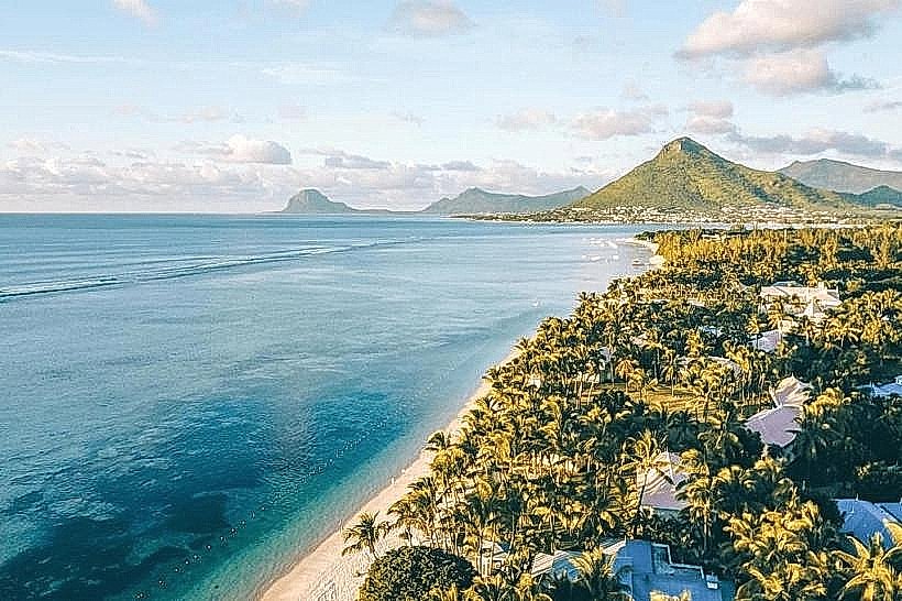
Flic en Flac Beach is a prominent public beach located on the western coast of Mauritius in the Black River District. It is one of the longest beaches on the island, stretching approximately 8 kilometers.
Visual Characteristics
The beach is characterized by fine white coral sand and is lined with a dense border of Casuarina (Filao) trees, which provide extensive natural shade. The turquoise lagoon is protected by a coral reef about 400 to 500 meters offshore, resulting in calm, shallow waters. The shoreline offers unobstructed views of the sunset over the Indian Ocean and the silhouette of Le Morne Brabant mountain to the south.
Location & Access Logistics
The beach is situated in the village of Flic en Flac, roughly 25 kilometers southwest of Port Louis and 15 kilometers from Quatre Bornes. Access is via the Flic en Flac Road (B34) off the A3 main road. Public transport is available via bus routes from Port Louis (Route 123) and Quatre Bornes (Route 174). Large public parking areas are situated at several intervals along the coastal road, primarily near the northern and central sections.
Historical & Ecological Origin
The name "Flic en Flac" is derived from an old Dutch phrase, Fried Landt Flaak, meaning "Free and Flat Land." Geologically, the beach is formed from crushed coral and shell deposits on a basaltic volcanic base. The lagoon serves as a significant marine habitat for tropical fish and coral species, although the seafloor near the shore contains coral fragments and sea urchins, making the use of swimming shoes advisable.
Key Highlights & Activities
Swimming and snorkeling are primary activities due to the calm lagoon conditions. The reef provides several diving spots accessible by short boat trips. The beach is a major site for "sundowners" (watching the sunset) and weekend picnicking by local residents. Water sports, including glass-bottom boat tours and dolphin-watching excursions, frequently depart from the northern end of the beach.
Infrastructure & Amenities
The public beach is well-equipped with infrastructure, including multiple blocks of public restrooms, showers, and changing rooms. The coastal road is lined with a high concentration of snack stands (roulottes) selling local street food, as well as upscale restaurants and hotels. 4G and 5G cellular coverage is consistently strong across the entire beach.
Best Time to Visit
The best time for clear water and calm conditions is during the Mauritian winter and spring (May to October). Early morning offers the calmest waters for swimming, while late afternoon (17:00–18:30) is the optimal time for sunset photography. Weekdays are significantly quieter than weekends and public holidays, when the beach reaches high capacity.
Facts & Legends
Flic en Flac was a small, quiet fishing village until the late 20th century when it underwent rapid development to become a major tourism hub. A local historical fact is that the area was once used primarily for lime production, with several historic lime kilns still located in the broader Black River region.
Nearby Landmarks
Casela Nature Parks - 4.5km East
Tamarin Bay - 8.2km South
Wolmar Public Beach - 3.5km South
Pasadena Shopping Mall - 0.5km East
La Pirogue - 1.2km South