Information
Landmark: Île aux CerfsCity: Trou dEau Douce
Country: Mauritius
Continent: Africa
Île aux Cerfs, Trou dEau Douce, Mauritius, Africa
Île aux Cerfs is a 100-hectare leisure islet situated within the largest lagoon of Mauritius, located off the east coast at Trou d’Eau Douce in the Flacq District.
Visual Characteristics
The island is defined by extensive sandbanks of fine white coral sand that shift with the tides, creating a shallow "sand river" between the main islet and the adjacent Îlot Mangénie. The interior is a mix of volcanic rock, mangrove forests, and manicured casuarina groves. The surrounding lagoon is characterized by exceptionally clear, shallow turquoise water. A significant portion of the interior is occupied by a 18-hole championship golf course designed by Bernhard Langer.
Location & Access Logistics
The islet is located approximately 1 kilometer from the mainland. Primary access is via taxi-boats departing from the Trou d’Eau Douce public jetty every 20–30 minutes. Private catamarans and speedboats also depart from Grand Baie (North) and Pointe d'Esny (South) for full-day excursions. The crossing from Trou d’Eau Douce takes approximately 15 minutes. Visitors arriving by car can park at the public jetty in Trou d’Eau Douce.
Historical & Ecological Origin
The name "Île aux Cerfs" (Island of Stags) originates from the Java deer that were introduced to Mauritius and once swam to the island to graze. While deer are no longer present on the islet, the ecosystem is a vital part of the eastern lagoon's fringing reef system. Geologically, it is a low-lying basaltic formation covered by Holocene sand deposits.
Key Highlights & Activities
Water Sports: Parasailing, speed-boating, and "undersea walks" are concentrated on the northern beach.
Golfing: The Île aux Cerfs Golf Club is an international-standard course covering the southern half of the island.
Snorkeling: The best coral patches are located near the reef on the eastern side, away from the main swimming beaches.
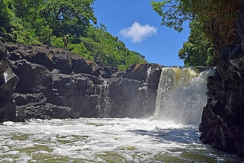
Grande Rivière Sud Est (GRSE) Waterfall: Most boat trips combine a visit to the islet with a detour to this nearby river mouth waterfall.
Infrastructure & Amenities
The northern tip of the island is highly developed for tourism, featuring three restaurants (Sands Grill, La Chaumière, and Langer’s Grill), several bars, and a local craft market. Public restrooms and showers are available near the main jetty. Sunbeds and umbrellas are available for rent. 5G cellular coverage is stable across the island. The southern portion remains exclusive to golfers and guests of the Bubble Lodge (eco-friendly transparent accommodation).
Best Time to Visit
To avoid peak crowds, arrivals before 09:30 are recommended. The island experiences high visitor volume between 11:00 and 15:00. During the winter months (June–August), the east coast can be windy; the central sandbank area remains relatively sheltered.
Facts & Legends
A local geographic feature is the "tital movement" of the sandbanks which can completely close the channel to Îlot Mangénie during spring low tides, allowing visitors to walk between the two islands. Despite its "desert island" marketing, the islet attracts over 800,000 visitors annually, making it the most frequented offshore destination in Mauritius.
Nearby Landmarks
Trou d’Eau Douce Village: 1.2km West
GRSE Waterfall: 3.5km South (via boat)
Îlot Mangénie: 0.1km North
Anahita Wilderness Sanctuary: 2.0km South
Belle Mare Beach: 8.0km North