Information
Landmark: Issaquah Alps TrailsCity: Issaquah
Country: USA Washington
Continent: North America
Issaquah Alps Trails, Issaquah, USA Washington, North America
The Issaquah Alps refer to a collection of prominent foothills and mountains located east of Seattle in the Issaquah area, Washington. These hills offer extensive trail networks that attract hikers, trail runners, mountain bikers, and nature enthusiasts year-round. The Issaquah Alps include Tiger Mountain, Cougar Mountain, Squak Mountain, Taylor Mountain, and Rattlesnake Mountain, each with unique trail systems, natural features, and hiking experiences. Here is a detailed overview of the key trails and characteristics of each:
Tiger Mountain Trails
Tiger Mountain is the largest and most popular among the Issaquah Alps, known for steep climbs, rugged terrain, and spectacular views. It is a favorite for hikers seeking a good workout and panoramic vistas.
Poo Poo Point via Chirico Trail: This is one of the most iconic hikes on Tiger Mountain. It is a moderately strenuous 3.8-mile round-trip route with approximately 1,800 feet of elevation gain. The trail climbs steadily through dense second-growth forests to Poo Poo Point, a wide rocky outcrop famous as a paragliding launch site. From here, hikers are rewarded with sweeping views of the Issaquah Valley, Lake Sammamish, and on clear days, Mount Rainier and the Cascade Range.
West Tiger #3 Trail: This trail is about 4.5 miles round-trip with a 1,400-foot elevation gain, considered moderately difficult. The trail ascends through forested terrain to viewpoints overlooking Tiger Mountain’s ridges and surrounding wilderness. It’s a less trafficked alternative to Poo Poo Point, popular for both hiking and trail running.
K-3 Trail: A shorter but steep 0.6-mile one-way trail that serves as a connector to the West Tiger Ridge. It climbs sharply to a ridgeline offering excellent views. This trail is often used as part of longer loop routes on Tiger Mountain.
Adventure Trail: A gentler 1.4-mile round-trip trail ideal for families or those seeking an easier walk. It meanders through forested areas with interpretive signage about the local ecosystem.
Cougar Mountain Trails
Cougar Mountain is less rugged than Tiger but rich in dense forests, wetlands, and historical remnants from its mining and military past. Trails here offer a mix of moderate hikes and leisurely walks.
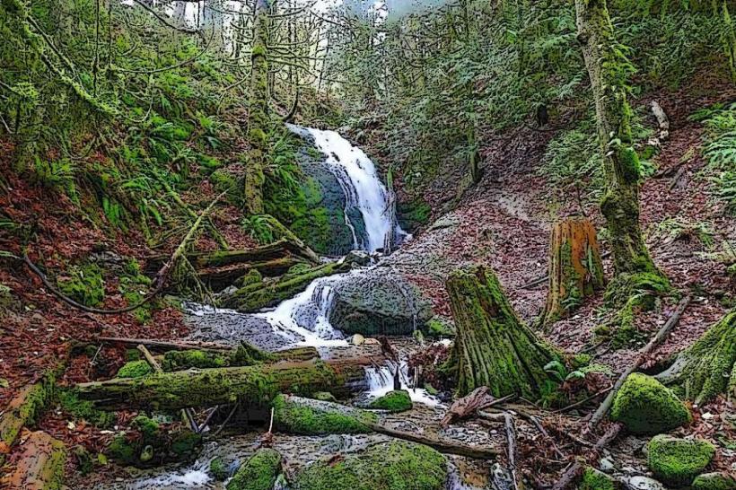
Coal Creek Falls Trail: A 2.5-mile round-trip hike that leads to a beautiful, seasonal waterfall. The trail follows Coal Creek through lush forest and mossy terrain, making it especially scenic during wetter months.
Anti-Aircraft Peak Loop: This 4.5-mile loop trail is moderately challenging, ascending to Anti-Aircraft Peak. It features remnants of old military bunkers and gun emplacements from World War II. The peak offers wide views of the surrounding forested mountains and valleys.
Wilderness Peak Loop: Spanning approximately 5.5 miles, this loop trail covers varied terrain, including forested ridges and small meadows. The elevation gain is moderate, and the trail is known for its peaceful, less crowded environment.
Squak Mountain Trails
Squak Mountain offers a quieter hiking experience with trails winding through mature forests and ridges, providing occasional viewpoints.
Margaret’s Way to Debbie’s View: This trail is around 6.8 miles one-way with about 1,500 feet of elevation gain. It traverses from Margaret’s Way Trailhead across forested slopes and ridge lines to Debbie’s View, a scenic overlook featuring views of Mount Rainier, the Cascade Mountains, and surrounding valleys.
Bullitt Fireplace Trail: A 4.1-mile trail leading hikers to the historic Bullitt family fireplace ruins, a remnant from early 20th-century settlement. The trail passes through a heavily wooded area with some elevation changes and offers a glimpse of local pioneer history.
Taylor Mountain Trails
Taylor Mountain is less developed but offers peaceful, less crowded trails perfect for those seeking solitude in nature.
Holder Knob + Holder Ridge Trail Loop: This loop stretches about 8.5 miles and features moderate elevation gain. It circles around Taylor Mountain, crossing through dense forests and ridges, offering solitude and occasional wildlife sightings.
Rattlesnake Mountain Trails
Although technically just south of the Issaquah Alps proper, Rattlesnake Mountain is closely associated with the region and offers one of the most popular hikes in the area.
Rattlesnake Ledge Trail: This 4-mile round-trip hike has a moderate to strenuous elevation gain of about 1,160 feet. The trail climbs through dense forest before opening up to a dramatic rock ledge overlooking Rattlesnake Lake. From the ledge, hikers enjoy expansive views of the surrounding mountains and water, making it a highly frequented trail on weekends and holidays.
Issaquah-Preston Trail
This trail follows a historic rail corridor and provides a flat, easy-to-moderate 5.4-mile one-way path connecting the towns of Issaquah and Preston. It is used for walking, jogging, biking, and nature observation. The trail is relatively level, with occasional forested and open areas along the route, making it accessible for most fitness levels.
Rainier Trail
Located near downtown Issaquah, the Rainier Trail is a 2.5-mile one-way trail that follows the old Seattle Lake Shore & Eastern Railway grade. It offers a pleasant walk through a mix of urban and natural settings, passing through forested areas and giving hikers a taste of the region’s transportation history.
Additional Information
The Issaquah Alps Trails Club is a local organization dedicated to maintaining the trail systems, organizing guided hikes, and promoting conservation efforts. The club regularly offers hikes of varying difficulties, educational events, and volunteer opportunities to protect and enjoy the natural beauty of the Issaquah Alps.
The trail systems vary in difficulty from easy family-friendly walks to challenging uphill climbs. Most trails are well-marked, and several maps and guides are available locally for hikers to plan their outings safely. The trails are open year-round, though winter conditions can make some higher elevation trails icy or snowy.
The Issaquah Alps provide a natural escape close to urban centers, making them an important resource for outdoor recreation, nature education, and community wellness in the greater Seattle area.

