Information
Landmark: Kastoria LakeCity: Kastoria
Country: Greece
Continent: Europe
Kastoria Lake, Kastoria, Greece, Europe
Kastoria Lake (Lake Orestiada) is a high-altitude tectonic lake situated in the Western Macedonia region of Greece, surrounding the peninsula upon which the city of Kastoria is built. It sits at an elevation of approximately 630 meters above sea level and is a designated Natura 2000 protected site due to its significant avian biodiversity.
Visual Characteristics
The lake covers a surface area of 28 square kilometers with an average depth of 4 meters. Its waters are characterized by a green-grey tint resulting from high phytoplankton density, and the shoreline features extensive reed beds and groves of century-old plane trees. The perimeter is defined by the steep limestone slopes of Mount Vitsi and the urban stone-and-wood mansions of the Apozari and Dolcho districts.
Location & Access Logistics
The lake is the central geographic feature of the Kastoria prefecture, accessible via the Egnatia Odos (A2) motorway. The city of Kastoria sits directly on its western shore; a 9-kilometer paved perimeter road circumnavigates the peninsula, suitable for bicycles and pedestrians. Regional KTEL buses connect the lakefront to Thessaloniki and Kozani, while the Kastoria National Airport (Aristotelis) is located 12 kilometers south.
Historical & Ecological Origin
The lake was formed during the Miocene epoch as a result of tectonic shifts in the Pindus mountain range. Historically, it has been the center of the regional fur-trading economy and local fishing. In 1932, a Neolithic lake settlement was discovered at Dispilio on the southern shore, revealing that the lake has supported human habitation since approximately 5500 BCE.
Key Highlights & Activities
Birdwatching is a primary activity, as the lake hosts over 200 species including Dalmatian pelicans and pygmy cormorants. Boat tours depart from the city pier, navigating the peninsula to the Dragon's Cave. The perimeter road provides access to several Byzantine churches and the Panagia Mavriotissa Monastery, located at the edge of the water.
Infrastructure & Amenities
The urban shoreline is fully developed with paved walkways, benches, and lighting. Public restrooms are located in the municipal park and near the southern entrance of the city. 4G and 5G mobile signals are robust throughout the lake basin. Numerous cafes and restaurants are concentrated along the northern and southern waterfronts, while traditional wooden "karavia" boats provide commercial transport and sightseeing.
Best Time to Visit
The lake is most visually striking during the autumn (October–November) when the surrounding plane trees change color. Winter (January–February) often sees the lake surface freeze completely, allowing for unique photography of the trapped ice. The best time for photography is during the early morning "blue hour" when the water surface is typically glassy and reflects the city architecture.
Facts & Legends
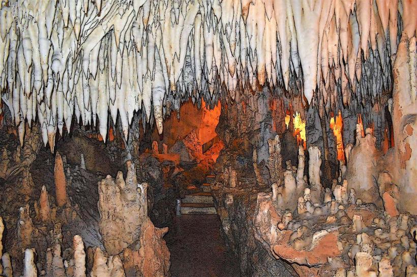
Local folklore speaks of a dragon that guarded the gold mines inside the Dragon's Cave on the lakeshore; the cave was only rediscovered in the 1940s and contains seven underground lakes. A verified historical oddity is the "Dispilio Tablet," a wooden artifact found in the lake mud engraved with symbols dated to 5260 BCE, which predates Sumerian cuneiform script.
Nearby Landmarks
Dragon's Cave: 2.5km East
Panagia Mavriotissa Monastery: 3.2km East
Dispilio Lakeside Neolithic Settlement: 7.5km South
Byzantine Museum of Kastoria: 0.4km West
Dolcho Traditional District: 0.2km West