Information
Landmark: Saline BayCity: Mayreau
Country: Saint Vincent and the Grenadines
Continent: North America
Saline Bay, Mayreau, Saint Vincent and the Grenadines, North America
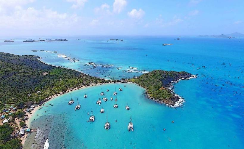
Saline Bay is a coastal area located on the island of Mayreau in Saint Vincent and the Grenadines. It is characterized by its shallow, clear waters and sandy shoreline.
Visual Characteristics
The bay features a crescent-shaped beach composed of fine, light-colored sand. The water depth is minimal near the shore, transitioning to deeper blue further out. The surrounding land is covered in low-lying scrub vegetation and scattered palm trees. No significant rock formations are present within the bay itself.
Location & Access Logistics
Saline Bay is situated on the western side of Mayreau. Access is primarily by boat, as Mayreau has no airport and limited road infrastructure. Small charter boats and water taxis frequently service the bay from neighboring islands like Union Island and Canouan. For visitors arriving by private yacht, anchoring is possible in the bay, though depths vary. There is no direct road access from the main settlement of Mayreau; a walking path of approximately 1.5km, traversing hilly terrain, connects the settlement to the bay.
Historical & Ecological Origin
Saline Bay is a natural coastal formation. Its name likely derives from historical observations of salt deposits or the saline nature of the water, though current salinity levels are typical for a Caribbean bay. The bay's ecosystem is characterized by seagrass beds in shallower areas, supporting marine life.
Key Highlights & Activities
Swimming is possible in the calm, shallow waters. Snorkeling can be done along the reef edge, approximately 50 meters offshore. Kayaking and paddleboarding are suitable activities due to the bay's sheltered nature. Beachcombing for shells is also a common activity.
Infrastructure & Amenities
There are no permanent structures or facilities directly on Saline Bay. Visitors should bring their own supplies, including water and food. Shade is limited to natural tree cover at the edge of the beach. Cell phone signal is generally weak to non-existent within the bay itself.
Best Time to Visit
The best time of day for photography is generally mid-morning to early afternoon when sunlight is most direct, illuminating the water clarity. The dry season, from December to May, offers the most consistent weather with minimal rainfall. High tide is preferable for swimming and water activities to ensure adequate water depth across the bay.
Facts & Legends
A local anecdote suggests that during exceptionally low tides, small, naturally formed salt pans can be observed near the western end of the beach, though this is not a consistent phenomenon. The bay is a known nesting site for sea turtles during specific seasons.
Nearby Landmarks
- Salt Whistle Bay (0.8km North)
- Mayreau Village (1.5km Northeast)
- The Tobago Cays Marine Park (3.5km Southeast)