Information
City: Cap MalheureuxCountry: Mauritius
Continent: Africa
Cap Malheureux, Mauritius, Africa
Cap Malheureux serves as a primary residential and maritime landmark in the Rivière du Rempart District at the northernmost tip of Mauritius. It functions as a critical site for the local artisanal fishing industry and a strategic viewpoint for the northern islets.
Historical Timeline
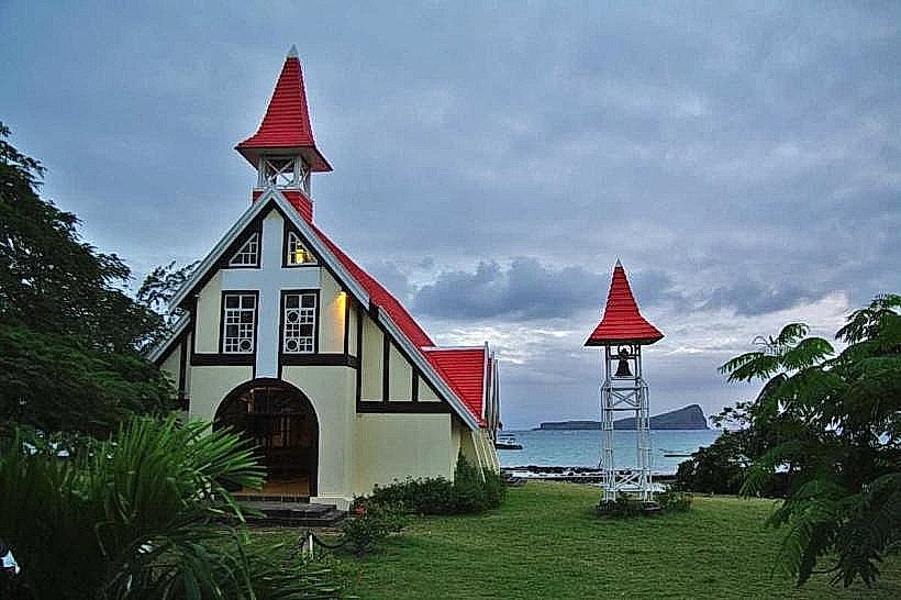
The area was named "Cap Malheureux" (Cape of Misfortune) by French settlers following numerous shipwrecks on its jagged reefs. The primary event shaping the current urban form occurred on November 29, 1810, when British forces landed here to initiate the final invasion of the island, ending French rule. The construction of the Notre Dame Auxiliatrice chapel in 1938 established the site as a permanent cultural and religious focal point.
Demographics & Population
The village has a permanent population of approximately 5,000. The demographic composition is 55% Creole, 35% Indo-Mauritian, and 10% foreign expatriates, primarily of French origin. The median age is 38 years.
Urban Layout & Key Districts
The village is organized linearly along the B11 coastal road. Key districts include the Chapel Zone (North), the primary tourist and religious core; the Fishing Port, located immediately adjacent to the chapel; and Anse La Raie (East), a specialized zone for kitesurfing and high-end residential estates.
Top City Landmarks
Notre Dame Auxiliatrice (Red-roofed chapel)
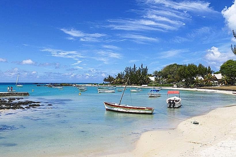
Cap Malheureux Public Beach
The Cemetery of Cap Malheureux
Bain Boeuf Beach (South periphery)
Anse La Raie Lagoon
Transportation Network
Movement is facilitated by the B11 coastal road. Reliable bus transit is provided by the Triolet Bus Service (TBS), connecting the village to Grand Baie and Port Louis. There is no Metro Express service. Ride-sharing via Yugo is available. Official taxis are white with yellow signage, typically stationed near the chapel entrance. Traffic is generally light, increasing during Sunday mass and wedding ceremonies.
Safety & "Red Zones"
The safety level is high. Avoid unlit beach sections and the secluded rocky outcrops near the cemetery after dark. Common scams are rare but include "unofficial" boat captains offering tours to Coin de Mire without valid safety permits or insurance.
Digital & Financial Infrastructure
Average internet speed is 40-60 Mbps. Main carriers are my.t and Emtel. Card acceptance is moderate; while upscale restaurants accept cards, local "tabagies" and the fish market are strictly cash-only. There are no ATMs in the village center; the nearest are in Grand Baie or Pereybere (3-5 km away).
Climate & Air Quality
Temperatures range from 17°C to 25°C in winter and 23°C to 32°C in summer. The region is exposed to northern trade winds, providing a cooling effect during the summer months. Air quality is exceptional due to the lack of industry and the direct influence of the Indian Ocean.
Culture & Social Norms
A 10% tip is standard in restaurants. Handshakes are the standard greeting. Dress code is conservative when entering the chapel (shoulders and knees covered). Swimwear is prohibited in the chapel grounds and local shops. Smoking is restricted in public parks and near the cemetery.
Accommodation Zones
Stay in Bain Boeuf for quiet residential apartments and proximity to swimming beaches.
Stay in Anse La Raie for luxury eco-hotels and direct access to kitesurfing zones.
Local Cost Index
1 Espresso: 110 MUR ($2.40 USD)
1 Standard Lunch: 350 MUR ($7.65 USD)
1 Bus Ticket: 30-40 MUR ($0.65 - $0.90 USD)
Nearby Day Trips
Coin de Mire (Gunner's Quoin): 4 km (20 minutes by boat)
Grand Baie: 6 km (10 minutes)
Pereybere Beach: 3 km (5 minutes)
Flat Island (Île Plate): 12 km (1 hour by catamaran)
Facts & Legends
The village is the subject of a persistent legend regarding the "Paul and Virginie" shipwreck; while the fictional Le Saint-Géran sank elsewhere, local folklore often associates the tragic imagery with this coast. A verified historical oddity is that the red-roofed chapel was built specifically to commemorate the sailors who perished on the reefs, yet it has become the most photographed structure in Mauritius for weddings.