Information
Landmark: Cap Malheureux BeachCity: Cap Malheureux
Country: Mauritius
Continent: Africa
Cap Malheureux Beach, Cap Malheureux, Mauritius, Africa
Cap Malheureux Beach is a scenic coastal area located at the northernmost tip of Mauritius. It is primarily a functional fishing beach rather than a traditional swimming destination, defined by its direct view of the northern islets.
Visual Characteristics
The beach is characterized by a narrow strip of white coral sand interspersed with dark volcanic basalt rocks. The shoreline is dotted with colorful artisanal fishing boats (pirogues). The water is shallow and crystal clear, featuring a sandy bottom with patches of volcanic rock and seagrass. The most prominent visual feature is the unobstructed view of Coin de Mire (Gunner's Quoin), a massive basalt island rising 163 meters from the sea, located 4km offshore.
Location & Access Logistics
The beach is situated on the B13 Coastal Road, approximately 6km north of Grand Baie.
Driving: Follow the B13 road to the terminus of the northern tip. A paved public parking area is located directly between the beach and the Notre Dame Auxiliatrice church.
Public Transport: Bus route 215 from Grand Baie terminates here.
Access: Public and free 24/7. While the beach is accessible, the rocky terrain requires caution.
Historical & Ecological Origin
The name "Cap Malheureux" (Cape of Misfortune) refers to the dangerous reefs that caused many shipwrecks. Historically, this is where the British fleet landed in 1810 to begin their conquest of the island. The area marks the transition between the calm western lagoons and the more exposed northern seas. The ecological environment is dominated by coastal scrub and Filao trees, with the lagoon serving as a vital nursery for local reef fish.
Key Highlights & Activities
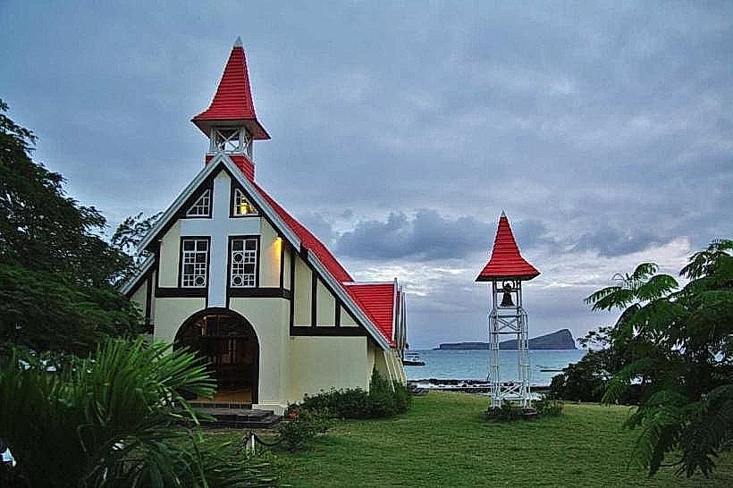
Photography: This is one of the most photographed spots in Mauritius, particularly the composition of the red-roofed church, the fishing boats, and Coin de Mire.
Boating: The stone jetty serves as a departure point for private boat trips to the northern islands (Île Plate and Îlot Gabriel).
Observation: Visitors can watch local fishermen bring in their daily catch (typically octopus, red snapper, and parrotfish) in the early afternoon.
Swimming: Possible in small sandy patches, but limited by boat traffic and rocks.
Infrastructure & Amenities
The site is well-equipped for short visits.
Facilities: Public restrooms and outdoor showers are located in the adjacent park.
Food: Several street food trailers in the parking area sell "boulettes" (dumplings), "roti," and fresh pineapple.
Connectivity: 5G signal is excellent.
Accessibility: The parking and park areas are flat and accessible, but the beach itself is narrow and rocky.
Best Time to Visit
The beach is best visited in the late afternoon (16:30–18:30) for the sunset, which sets behind the western coastline while illuminating the northern islands in orange hues. Mid-morning is ideal for capturing the most vibrant turquoise water colors.
Facts & Legends
Local maritime history notes that the "Coin de Mire" islet served as a strategic lookout point for French and British naval forces. A local tradition involves the "blessing of the boats," which occasionally takes place on the shoreline in front of the chapel during religious festivals.
Nearby Landmarks
Notre Dame Auxiliatrice (Red Roof Church): 0.05km West
Cap Malheureux Cemetery: 0.4km East
Bain Boeuf Beach: 1.5km Southwest
Anse La Raie Lagoon: 2.2km East
Grand Baie: 6.5km Southwest