Information
City: Dak NongCountry: Vietnam
Continent: Asia
Dak Nong, Vietnam, Asia
Dak Nong serves as a critical strategic highland province in the Central Highlands (Tay Nguyen), functioning as a primary hub for bauxite mining and renewable energy. It is situated on the M'Nong plateau, bordered by Dak Lak to the north, Lam Dong to the east, and Cambodia to the west, with Gia Nghia City as its administrative center.
Historical Timeline
The region was historically the territory of the M'Nong and Ma ethnic groups. It was part of Dak Lak Province until the most significant political shift on January 1, 2004, when Dak Nong was officially established as a separate province. The 2020 recognition of the Dak Nong Geopark as a UNESCO Global Geopark and the 2020 elevation of Gia Nghia to city status are the primary events that shaped the current urban form and shifted the economy toward sustainable tourism and high-tech agriculture.
Demographics & Population
The provincial population is approximately 650,000. The demographic profile is diverse, consisting of 40 ethnic groups. The Kinh (65%) are the majority, followed by the M'Nong (9%), Tay (6%), and Nung (5%). The median age of the population is 28.5 years.
Urban Layout & Key Districts
The city of Gia Nghia is built on a series of rolling hills and valleys, creating a non-linear urban grid. Nghia Duc (Central) is the administrative core. Nghia Thanh serves as the commercial hub surrounding the central market. Rural districts like Krong No (North) and Dak Glong (East) contain the majority of the province's UNESCO geological sites and hydropower reservoirs.
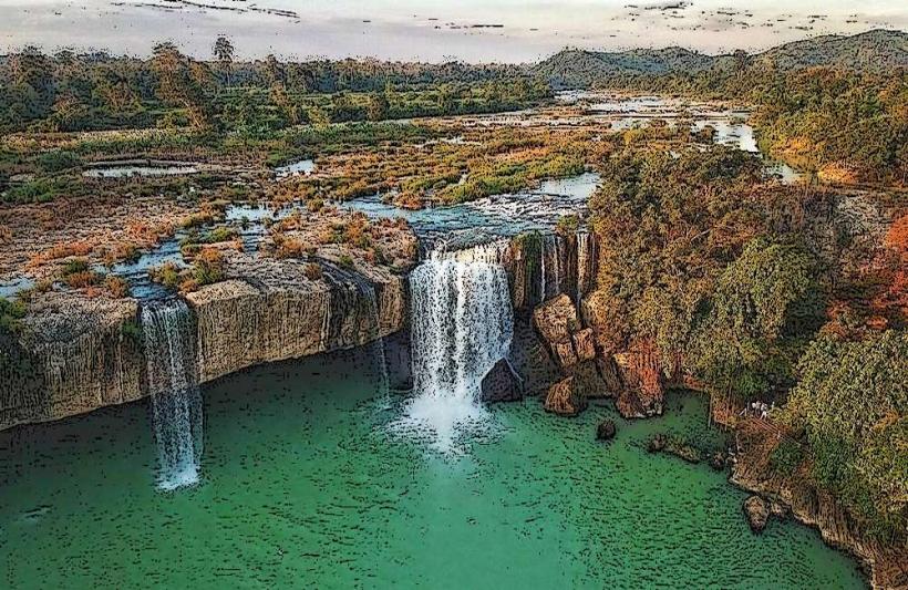
Top City Landmarks
Dak Nong UNESCO Global Geopark (various sites)
Lieng Nung Waterfall
Gia Nghia Central Lake
Phap Hoa Pagoda
Dak Mil Lake (Ho Tay Dak Mil)
Transportation Network
Movement is dominated by private motorbikes and private cars. There is no metro, tram, or railway system. Grab has a very limited presence in Gia Nghia; traditional taxis are the reliable standard. Official taxis include Taxi Gia Nghia (yellow) and Mai Linh (green). Traffic density is low, but the terrain is mountainous with steep gradients. National Highway 14 (Ho Chi Minh Road) is the primary logistical artery.
Safety & "Red Zones"
Dak Nong is categorized as highly safe. There are no specific "red zones." Caution is advised when driving on Highway 14 due to heavy sleeper buses and trucks. Visitors exploring the volcanic cave systems in Krong No must use certified guides and professional equipment to avoid structural or atmospheric hazards.
Digital & Financial Infrastructure
Average internet speed is 62 Mbps. Main mobile carriers are Viettel, Vinaphone, and Mobifone. Card acceptance is restricted to large hotels and the Vincom Plaza in Gia Nghia. Cash is mandatory for entrance fees to waterfalls and local markets. ATMs are concentrated in Gia Nghia and the town centers of Dak Mil and Ea T'ling.
Climate & Air Quality
Temperatures range from 16°C to 24°C in the cool season (December–January) and 22°C to 32°C in the dry season. Air quality is exceptionally high due to low industrial density and high forest cover. The rainy season (May–November) carries risks of flash floods and landslides in mountainous corridors.
Culture & Social Norms
Tipping is not standard. Handshakes are the common greeting. Dress code is conservative; modest clothing is required for Phap Hoa Pagoda. A critical social norm is the respect for the Space of Gong Culture; gongs are sacred instruments and should not be touched or played by visitors without explicit permission from village elders.
Accommodation Zones
Gia Nghia City: Recommended for administrative proximity, modern amenities, and central logistics.
Dak Mil Town: Recommended for a cooler climate and proximity to the Cambodian border and coffee plantations.
Local Cost Index
1 Espresso (Central Highlands Coffee): 20,000 VND ($0.85)
1 Standard Lunch (Com Lam/Grilled Pork): 55,000 VND ($2.30)
1 Taxi trip (3km): 50,000 VND ($2.05)
Nearby Day Trips
Chu Bluk Volcanic Cave System: 60 km (1.5 hours)
Ta Dung Lake (The "Ha Long Bay of the Highlands"): 45 km (1 hour)
Dray Sap and Gia Long Waterfalls: 90 km (2 hours)
Nam Nung Nature Reserve: 30 km (45 minutes)
Facts & Legends
A prominent local legend among the M'Nong concerns the "Gong of the Sun," which was said to be so powerful it could summon rain and ensure eternal harvests. A verified geological oddity is that the Chu Bluk volcanic cave system is the longest of its kind in Southeast Asia, featuring unique "gas vents" and lava molds of ancient trees that were flash-frozen by volcanic flows 2,000 years ago.