Information
City: HuarazCountry: Peru
Continent: South America
Huaraz, Peru, South America
Huaraz is the capital of the Ancash Region, situated in the Callejón de Huaylas valley at an elevation of 3,052 m. Known as the "Switzerland of Peru" and the "Capital of International Friendship," it is the primary global gateway for mountaineering and trekking in the Cordillera Blanca, the highest tropical mountain range in the world.
Historical Timeline
Founded in 1574 as a Spanish mining settlement (San Sebastián de Huaraz), the city was largely defined by a catastrophic $7.9$ magnitude earthquake in 1970. The tremor triggered a massive ice and mud avalanche from Mount Huascarán that buried the nearby town of Yungay and destroyed 95% of Huaraz. The modern city was rebuilt with international aid, resulting in a more grid-like, earthquake-resistant urban plan compared to other colonial Peruvian cities.
Demographics & Population
The population is approximately 120,000. The demographic is predominantly Mestizo and Quechua. The economy is centralized around high-altitude adventure tourism, regional commerce, and agriculture (wheat, potatoes, and corn).
Urban Layout & Key Districts
Plaza de Armas: The modern civic center, rebuilt after 1970; home to the Cathedral and the Archaeology Museum of Ancash.
Belén & Soledad: Historic neighborhoods that partially survived the 1970 earthquake, retaining some traditional narrow streets.
Huarupampa: A residential and commercial district hosting many of the city’s expedition agencies and climbing gear shops.
Centenario: A district north of the Quillcay River with a high density of local markets and transport terminals.
Top Landmarks & Sites
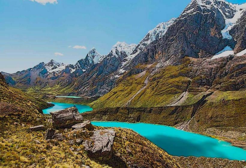
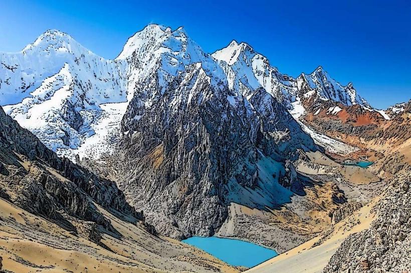
Huascarán National Park: A UNESCO site protecting Peru’s highest peak, Huascarán ($6,768$ m), and over 600 glaciers.
Laguna 69: A bright turquoise glacial lake at $4,600$ m; the region's most famous and physically demanding day hike.
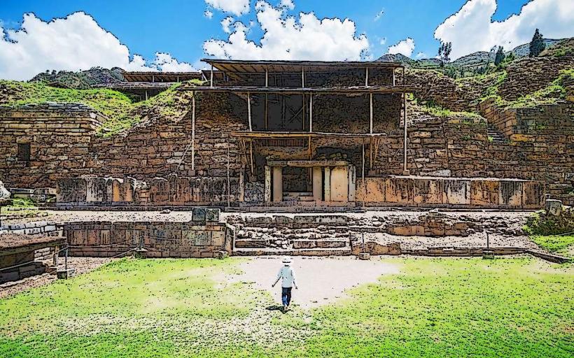
Chavín de Huántar: Located 3 hours away; a UNESCO-listed pre-Inca ceremonial center ($1200$ BCE) featuring underground stone galleries and the Lanzón monolith.
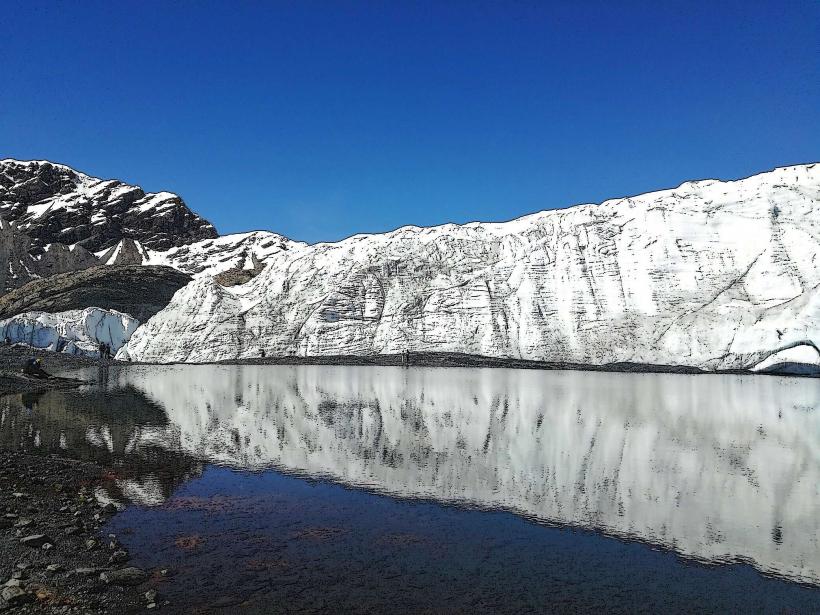
Pastoruri Glacier: One of the few glaciers in the world accessible by car; it serves as a "Climate Change Route" showcasing rapid glacial retreat.
Wilcacocha Lake: A popular acclimatization hike in the Cordillera Negra, offering a panoramic "postcard" view of the entire Cordillera Blanca range.
Transportation Network
Air: Comandante FAP Germán Arias Graziani Airport (ATA) serves limited domestic flights, but most travelers arrive by bus.
Road: Primarily accessed via the Pativilca-Huaraz Highway. Premium buses from Lima (Cruz del Sur, Movil Bus) take approximately 8 hours.
Local: Relies on "Colectivos" (shared vans) for transport to trailheads like Pitec (for Lake Churup) and Cebollapampa (for Laguna 69).
Safety & Altitude Health
Altitude Sickness: Huaraz is higher than Lima and requires immediate acclimatization. Do not attempt Laguna 69 on your first day.
Mountaineering Risks: The Cordillera Blanca is notorious for avalanches and technical climbing hazards. Always hire UIAGM-certified guides for glacial summits.
Seismic Hazard: The city sits in a high-risk zone for both earthquakes and glacial lake outburst floods (GLOFs).
Digital & Financial Infrastructure
4G/LTE is stable in the city center but non-existent once entering the National Park. The currency is the Peruvian Sol (PEN). ATMs are concentrated around the Plaza de Armas. Cash is mandatory for park entry fees, mountain guides, and rural transport.
Climate & Air Quality
Highland climate with two distinct seasons: Andean Summer (May–September), featuring dry, sunny days and sub-zero nights; and the Wet Season (October–April). Air quality is exceptionally high due to the lack of industry and proximity to high-altitude glaciers.
Culture & Social Norms
Mountaineering Culture: The city is a "base camp" town similar to Chamonix or Kathmandu; local life revolves around the climbing season.
Quechua Heritage: Indigenous traditions remain strong; traditional dress is common in the Central Market.
Cuisine: Specialized in Pachamanca (underground roast), Cuy Colorado (spicy guinea pig), and Llunca Kashki (wheat soup).
Local Cost Index (PEN)
1 Day Tour (Lake 69 or Chavín): S/ 60.00–S/ 90.00
1 Bowl of Llunca Kashki: S/ 10.00–S/ 15.00
1 National Park Entry (3-day pass): S/ 30.00
Facts & Legends
Legend says the name Huaraz comes from the Quechua word Waraq, meaning "dawn," as the morning sun first hits the peaks above the valley. A geographic fact: The Cordillera Blanca contains the highest density of tropical glaciers on Earth, accounting for roughly 70% of the world's tropical ice. Historically, the 1970 disaster led to the creation of Peru’s national civil defense system, as the city became the global focal point for disaster response research.