Information
City: ImoCountry: Nigeria
Continent: Africa
Imo, Nigeria, Africa
Imo State serves as the primary entertainment and hospitality hub of Southeast Nigeria, functioning as a central logistics node for the region's oil and gas services and human capital development. It is located in the heart of Igboland, bordered by Anambra to the north and Rivers to the south.
Historical Timeline
Imo State was created on February 3, 1976, during the military administration of Murtala Mohammed, carved out of the old East Central State. It transitioned through the colonial era as a center for the palm oil industry and the British administrative district of Owerri. The most significant political reconstruction followed the post-civil war recovery, which saw Owerri redesigned into a modern urban layout. The primary event shaping its current urban form was the 1970s Fingerplan development, which utilized a structured master plan to expand the city beyond its traditional core.
Demographics & Population
The state population is estimated at 5,400,000 as of 2026, with the capital, Owerri, housing approximately 1,150,000 residents. The demographic is overwhelmingly Igbo (99%+). The median age is 19.2 years.
Urban Layout & Key Districts
The state is organized around the Owerri metropolitan area, known for its high density of hotels and boulevards. Key districts include the Ikenegbu and Aladinma Layouts, the primary social and commercial hubs; New Owerri, the modern administrative extension containing the state secretariat; and the World Bank Housing Estate. Development follows a well-defined grid in the central areas, unique for the region.
Top City Landmarks
Assumpta Cathedral (Italian Renaissance architecture)
Imo State Government House (Douglas House)
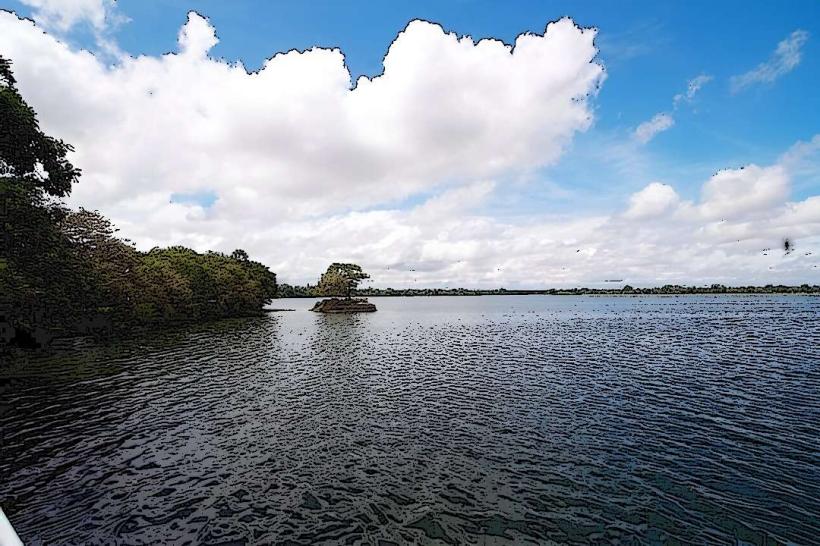
Oguta Lake (Confluence of blue water and muddy Urashi River)
Nekede Zoo
Imo Palm Plantation (formerly Ada Palm)
Transportation Network
Movement between hubs relies on the Owerri-Onitsha and Owerri-Port Harcourt expressways. Internal transit in Owerri is dominated by "Keke" (tricycles) and minibuses; commercial motorcycles (Okada) are restricted in the capital. Sam Mbakwe International Cargo Airport provides major air links. Traffic density is extreme at the Control Post and Wetheral Road intersections.
Safety & "Red Zones"
The safety level is moderate. Caution is advised in the Orlu and Okigwe zones due to regional security volatility and sporadic separatist activities. Within Owerri, avoid walking alone in the Douglas Road market area after sunset due to petty theft. Use verified ride-hailing apps for late-night movements between social venues.
Digital & Financial Infrastructure
Average internet speeds are 30–50 Mbps on 4G/5G networks. Main carriers are MTN, Airtel, and Glo. Card acceptance is the highest in the Southeast due to the booming hospitality sector. ATMs are concentrated along Bank Road and Wetheral Road.
Climate & Air Quality
Temperatures range from 22°C to 34°C. The state has a tropical rainforest climate with exceptionally high humidity and heavy rainfall from April to October. Air quality is generally moderate, though particulate levels rise in the dry season (December–February).
Culture & Social Norms
Tipping is common (5–10%) given the service-oriented economy. Respect for the "Eze" (traditional ruler) is mandatory in rural autonomous communities. The state is renowned for its "Ofe Owerri" soup, a cultural staple. Alcohol is widely available, with the state having the highest density of bars and lounges per square mile in Nigeria.
Accommodation Zones
New Owerri: Recommended for high security, luxury hotels, and proximity to government offices.
Ikenegbu Layout: Recommended for access to nightlife and a variety of dining options.
Local Cost Index
1 Espresso: ₦4,500 ($3.00)
1 Standard Lunch: ₦12,000 ($8.00)
1 Metro/Bus Ticket: ₦800 ($0.55) - Local Keke/minibus rate.
Nearby Day Trips
Oguta Lake Resort: 45 km (60 minutes)
Nekede Zoo: 10 km (20 minutes)
Mbari Cultural Center: Within city limits
Port Harcourt: 85 km (100 minutes)
Facts & Legends
Owerri is nicknamed the "Heartland" and the "Entertainment Capital of Nigeria." A local legend surrounds Oguta Lake, where the Blue Water and the Muddy Urashi River meet but do not mix; it is believed that the two waters represent a male and female deity who had a dispute and have refused to reconcile their currents ever since. This site remains a focal point for traditional prayers regarding conflict resolution.