Information
City: Kon TumCountry: Vietnam
Continent: Asia
Kon Tum, Vietnam, Asia
Kon Tum serves as the northernmost administrative hub of the Central Highlands, functioning as a vital link between Vietnam, Laos, and Cambodia at the Indochina tripoint. It is situated in a basin along the Dak Bla River, approximately 50 km north of Pleiku.
Historical Timeline
The region has been the ancestral home of the Ba Na people (the name Kon Tum means "Village of the Pool" in Ba Na). French missionary presence began in 1851, followed by formal colonial administration. The area was a major battleground during the Vietnam War, particularly during the 1972 Easter Offensive. A significant administrative shift occurred on June 12, 2025, when Kon Tum was officially incorporated into Quang Ngai Province as part of a national administrative consolidation. This reform merged the highland agricultural and mining sectors of Kon Tum with the coastal industrial zones of Quang Ngai.
Demographics & Population
The population of the Kon Tum area is approximately 540,000. It is one of Vietnam's most ethnically diverse regions; over 50% of residents belong to indigenous groups, primarily the Ba Na, Xo Dang, Gie Trieng, and Gia Rai. The Kinh (ethnic Vietnamese) constitute the remaining portion. The median age is approximately 29.5 years.
Urban Layout & Key Districts
The city of Kon Tum is built primarily on the northern bank of the Dak Bla River, which flows uniquely from East to West.
Thanh Binh Ward (Central): The historical and religious core.
Quyet Thang (Central): The primary commercial district.
Kon Klor (East): A cultural preservation ward featuring traditional communal structures.
Dak To & Ngoc Hoi (Northwest): Logistics hubs near the Bo Y International Border Gate.
Top City Landmarks
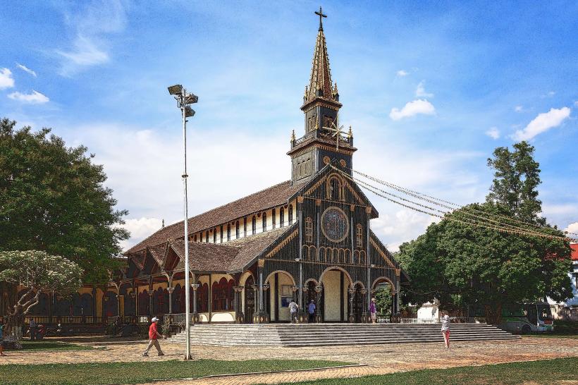
Kon Tum Wooden Church (Cathedral): Built in 1913, blending Romanesque architecture with Ba Na stilt-house styles.
Kon Klor Communal House (Nha Rong): One of the largest traditional Bahnar communal houses in the Highlands.
Kon Tum Bishop’s Palace: A French-Ba Na fusion structure housing a local ethnology museum.
Kon Klor Suspension Bridge: Spanning the Dak Bla River.
Kon Tum Prison Relic: A historical site from the French colonial era.
Transportation Network
Movement within the city relies on private motorbikes and local taxis. There is no metro or railway system. Grab has limited availability; traditional taxis like Mai Linh (green) are the reliable standard.
Air: Pleiku Airport (PXU) is the nearest aviation hub, 50 km (1 hour) to the south.
Road: National Highway 14 (Ho Chi Minh Road) connects the city to Da Nang and Buon Ma Thuot. Highway 24 connects to Quang Ngai.
Safety & "Red Zones"
Kon Tum is highly safe for international and domestic travelers. There are no designated "red zones." Caution is advised during the rainy season (May–October) due to landslides on Highway 24 and the Ho Chi Minh Road. Visitors should avoid exploring the deep forests of Chu Mom Ray National Park without a certified guide due to dense terrain and UXO risks in remote unmapped areas.
Digital & Financial Infrastructure
Average internet speed is 60 Mbps. Main mobile carriers are Viettel, Vinaphone, and Mobifone. Card acceptance is restricted to a few hotels (e.g., Indochine) and the Vincom+ center; cash is mandatory for all local dining and entry fees. ATMs are clustered in the central wards of Quyet Thang and Thong Nhat.
Climate & Air Quality
Temperatures range from 14°C to 22°C in the cool season (December–January) and 24°C to 34°C in the dry season. Air quality is exceptionally high. The rainy season (May–November) brings frequent, heavy afternoon thunderstorms and high humidity.
Culture & Social Norms
Tipping is not standard. Handshakes are the common greeting. Dress code is strictly conservative; shoulders and knees must be covered when entering the Wooden Church or any Plei (village) communal house. A specific social norm is the high respect for the Nha Rong; never enter a communal house unless invited by the village elder (Jarai/Bahnar).
Accommodation Zones
Kon Tum City Center: Recommended for logistical access to the Wooden Church, Bishop’s Palace, and dining.
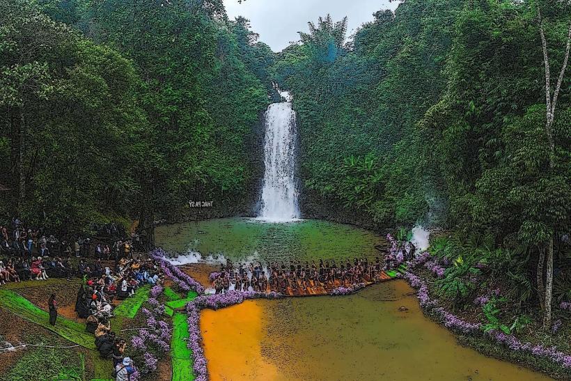
Mang Den Town: Recommended for those seeking a cooler, "mini-Dalat" climate and pine forest eco-resorts (55 km from the city).
Local Cost Index
1 Espresso (Highland Robusta): 20,000 VND ($0.85)
1 Standard Lunch (Sticky rice with bamboo shoots): 45,000 VND ($1.85)
1 Taxi trip (3km): 50,000 VND ($2.05)
Nearby Day Trips
Mang Den Plateau: 55 km (1.2 hours)
Indochina Tripoint (Vietnam-Laos-Cambodia border): 80 km (2 hours)
Dak To - Tan Canh Battlefield: 45 km (1 hour)
Chu Mom Ray National Park: 30 km (45 minutes)
Facts & Legends
A prominent local legend involves the Dak Bla River, which is said to flow "backward" (East to West) because of a tragic love story between two people from rival tribes on opposite banks. A verified historical oddity is the Kon Tum Wooden Church, which was constructed entirely without nails, using a complex system of mortise and tenon joints in Shorea roxburghii wood that has survived for over a century in the humid highland climate.