Information
City: TamarinCountry: Mauritius
Continent: Africa
Tamarin, Mauritius, Africa
Tamarin serves as a primary residential and maritime hub on the west coast of Mauritius, situated in the Black River District. It functions as the island's center for salt production and is a critical node for the western surfing and eco-tourism industries.
Historical Timeline
Tamarin was established as a fishing and salt-harvesting settlement during the French colonial period in the 18th century. It remained a quiet village until the mid-20th century, when it gained international recognition as a premier surfing destination. The primary event shaping the current urban form was the 2010s transition from a rural coastal village to a "Smart City," integrated with the Cap Tamarin development, which expanded the residential and commercial infrastructure inland.
Demographics & Population
The permanent population is approximately 4,500. The demographic profile is roughly 50% Creole, 35% Indo-Mauritian, and 15% European and South African expatriates. The median age is 36 years.
Urban Layout & Key Districts
The village is organized around the mouth of the Tamarin River and the A3 coastal road. Key districts include the Salt Pans (North), the historic industrial core; Black Rock (West), a high-density residential area; and Cap Tamarin (East), the modern commercial and educational extension.
Top City Landmarks
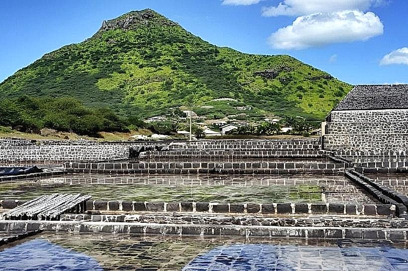
Tamarin Salt Pans
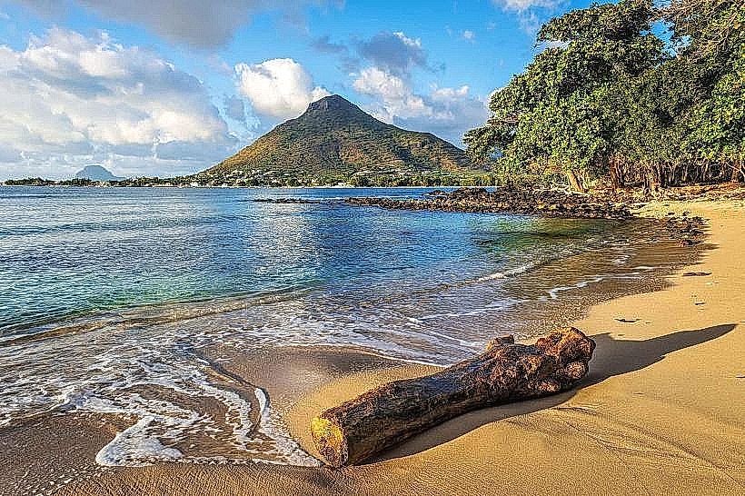
Tamarin Bay (Surfing and dolphin watching)
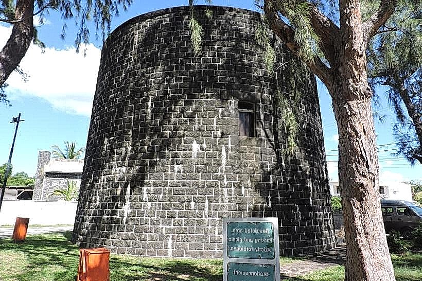
Martello Tower (Museum)
Salt-manned "Marais Salants"
La Tourelle du Tamarin Mountain
Transportation Network
Movement is facilitated by the A3 motorway. Bus routes connect the village to Port Louis and Quatre Bornes via the Black River line. Ride-sharing is available through the Yugo app. Official taxis are white with yellow markings, concentrated at the Cap Tamarin and La Preneuse stands. Traffic density is high at the Tamarin Bridge during morning and afternoon school runs.
Safety & "Red Zones"
The safety level is high. Avoid the unlit areas of the public beach and the river estuary after dark. Common scams include unlicensed boat operators promising dolphin swims without following environmental regulations.
Digital & Financial Infrastructure
Average internet speed is 50-80 Mbps. Main mobile carriers are my.t and Emtel. Card acceptance is high in the Super U complex and major restaurants; cash is required for local surf shops and small "tabagies." ATMs are located at Place Cap Tamarin and the Ruisseau Créole mall.
Climate & Air Quality
Temperatures range from 17°C to 25°C in winter and 23°C to 32°C in summer. The region is located in a "rain shadow," making it one of the driest parts of Mauritius. Air quality is excellent due to sea breezes and the lack of industrial manufacturing beyond salt processing.
Culture & Social Norms
A 10% tip is standard in restaurants. Handshakes are the common greeting. The social culture is heavily influenced by surf and outdoor lifestyles, yet conservative dress is required when away from the beach. Smoking is prohibited in public buildings and near the salt pans.
Accommodation Zones
Stay in Black Rock for immediate walking access to the surf breaks and the beach.
Stay in the La Preneuse area (South) for proximity to historical sites and quiet residential stays.
Local Cost Index
1 Espresso: 115 MUR ($2.50 USD)
1 Standard Lunch: 400 MUR ($8.75 USD)
1 Bus Ticket: 35 MUR ($0.75 USD)
Nearby Day Trips
Le Morne Brabant: 20 km (30 minutes)
Chamarel Seven Coloured Earth: 18 km (30 minutes)
Black River Gorges (Petrin entrance): 15 km (25 minutes)
Casela Nature Parks: 10 km (15 minutes)
Facts & Legends
Tamarin is home to the only remaining traditional salt pans in Mauritius, where salt is still harvested by hand from seawater. Local legend suggests that the dolphins of Tamarin Bay are the spirits of ancient mariners, while a verified historical oddity is that the village was the primary filming location for the 1970s cult surf film Forgotten Island of Santosha.