Information
Landmark: Blue Bay BeachCity: Blue Bay
Country: Mauritius
Continent: Africa
Blue Bay Beach, Blue Bay, Mauritius, Africa
Blue Bay Beach is a public coastal area located on the southeast tip of Mauritius in the Grand Port District. It is primarily known for its proximity to a protected marine park and its naturally occurring deep-water swimming zones.
Visual Characteristics
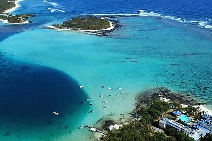
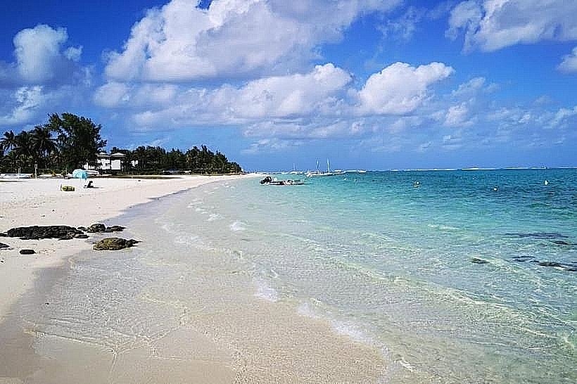
The shoreline is composed of fine, white coralline sand bordered by a dense grove of casuarina (filao) trees. The water exhibits a distinctive transition from transparent turquoise in the shallows to a deep cobalt blue as the seafloor drops sharply within the lagoon. Underwater visibility often exceeds 15 meters. The beach is protected from heavy Indian Ocean swells by a coral reef located approximately 800 meters offshore, maintaining a calm surface environment.
Location & Access Logistics
The beach is situated at the terminus of the B28 coastal road, roughly 5 kilometers from Sir Seewoosagur Ramgoolam International Airport. It is 10 kilometers from the town of Mahebourg. Public transport is available via bus line 198, which operates between Mahebourg and Blue Bay at 30-minute intervals. A large, paved public parking lot is located at the entrance. Boat access is centralized at the public jetty for transfers to nearby islets or the marine park core.
Historical & Ecological Origin
The area sits on a volcanic basalt base covered by thousands of years of coral sediment. Historically, the beach served as a small fishing outpost before the establishment of the Blue Bay Marine Park in 1997. Ecologically, it is a rare site in Mauritius where the lagoon depth allows large vessels and diverse marine life to come in close proximity to the shore. The adjacent coral gardens are protected under the Ramsar Convention.
Key Highlights & Activities
Swimming is the primary shoreline activity due to the lack of strong currents in the designated zones. Snorkeling is possible directly from the beach, though the most dense coral formations are reached via glass-bottom boats. The beach serves as the departure point for excursions to Ile des Deux Cocos and the Mahebourg bay area. Windsurfing and kitesurfing are common on the eastern edge of the bay where wind exposure is higher.
Infrastructure & Amenities
Public infrastructure includes a dedicated restroom and shower block, a police station at the entrance, and several paved walkways. 5G cellular coverage is available. Multiple food vendors and small restaurants are positioned along the perimeter of the parking area and under the casuarina trees. Benches and stone picnic tables are distributed throughout the shaded areas.
Best Time to Visit
The beach is most favorable for swimming during the Mauritian summer (November to April). For photography and water clarity, the hours between 08:00 and 10:30 are optimal. During the winter months (June to August), the southeast trade winds can be strong, making the area significantly cooler than the leeward west coast. Weekend crowds are high; weekdays offer greater seclusion.
Facts & Legends
A local geographic anomaly is the "blue hole" within the lagoon, a deep depression that gives the beach its name and allows for unique vertical temperature gradients in the water. The beach is also the site where the remains of the ship Dalblair can be seen on the reef; it is a local landmark used by fishermen for navigation since its grounding in 1902.
Nearby Landmarks
Blue Bay Marine Park (Core Zone): 0.5km South
Ile des Deux Cocos: 1.0km South
Pointe d'Esny: 1.2km North
Mahebourg Waterfront: 5.2km Northwest
Sir Seewoosagur Ramgoolam International Airport: 4.8km West