Information
Landmark: Budatín BridgeCity: Zilina
Country: Slovakia
Continent: Europe
Budatín Bridge, Zilina, Slovakia, Europe
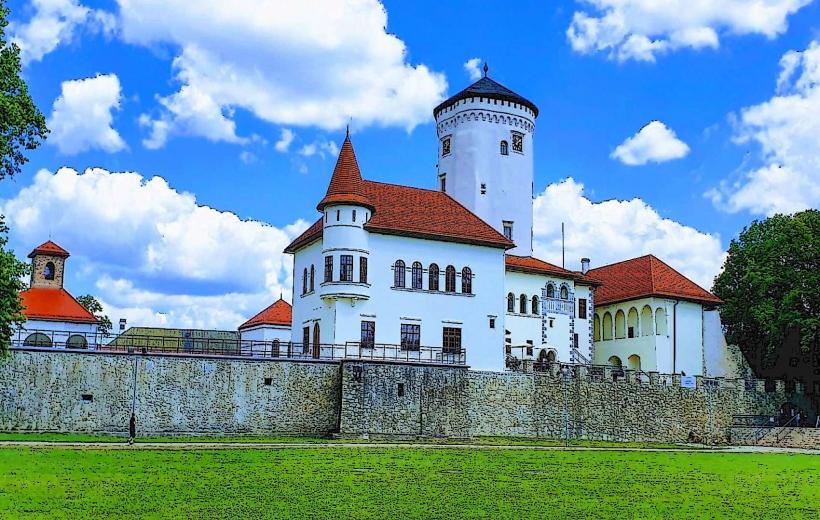
Budatín Bridge is a critical road and pedestrian span crossing the Váh River, connecting the central districts of Žilina with the northern Budatín borough. It serves as a primary transit link for local traffic and foot travelers accessing the nearby castle and park grounds.
Visual Characteristics
The bridge is a reinforced concrete beam structure supported by massive concrete piers anchored in the riverbed. It features two vehicle lanes flanked by elevated pedestrian sidewalks on both the eastern and western sides. The utilitarian design is characterized by grey industrial finishes, steel safety railings, and integrated street lighting masts.
Location & Access Logistics
The span is located on the I/11 and I/18 road corridors, approximately 1.8 kilometers north of Žilina’s central Mariánske Námestie. It is accessible via the Estakáda flyover or the riverside pedestrian paths. Public transport lines 21, 22, 27, 29, and 30 pass directly over the bridge to the Námestie hrdinov stop. Pedestrian access is maintained via stairs and ramps at both the southern (city) and northern (Budatín) embankments.
Historical & Ecological Origin
The current concrete structure was built in the mid-20th century to replace older wooden and steel spans destroyed during World War II. Historically, this site has been a strategic crossing point since the medieval era, originally served by a ford and later a toll bridge controlled by the Budatín Castle lords. The bridge crosses the Váh, Slovakia's longest river, at a point where the flow is regulated by the Žilina dam system.
Key Highlights & Activities
The bridge provides a panoramic vantage point for photographing Budatín Castle and the confluence of the Váh and Kysuca rivers. It is a major thoroughfare for cyclists using the Váh Cycle Route. Fishing is permitted in the waters beneath the bridge, subject to local regulations and seasonal permits.
Infrastructure & Amenities
The bridge is equipped with paved sidewalks and metal safety barriers. There are no restrooms or food vendors on the span itself; however, a gas station and several restaurants are located within 200 meters of the northern end. Mobile signal (5G) is consistently strong across the entire length of the crossing.
Best Time to Visit
Photography of the castle from the bridge is optimal during the "golden hour" shortly before sunset, as the light hits the western face of the castle tower. Morning hours provide better light for the river confluence looking West. High-traffic periods occur during morning and afternoon commutes (07:00–09:00 and 15:30–17:30).
Facts & Legends
The bridge stands near the site where historical toll collection took place for centuries, a right granted to the owners of the castle. During the 1848–1849 revolution, the area around the bridge was the site of a significant battle between Slovak volunteers and Hungarian revolutionary forces, a fact commemorated by a monument in the adjacent Budatín park.
Nearby Landmarks
Budatín Castle – 0.2km North
Budatín Castle Park – 0.25km North
Confluence of Váh and Kysuca Rivers – 0.3km Northwest
Dubbeň Hill – 1.5km Northeast
Žilina Railway Station – 1.6km South