Information
Landmark: Hardinge BridgeCity: Pabna
Country: Bangladesh
Continent: Asia
Hardinge Bridge, Pabna, Bangladesh, Asia
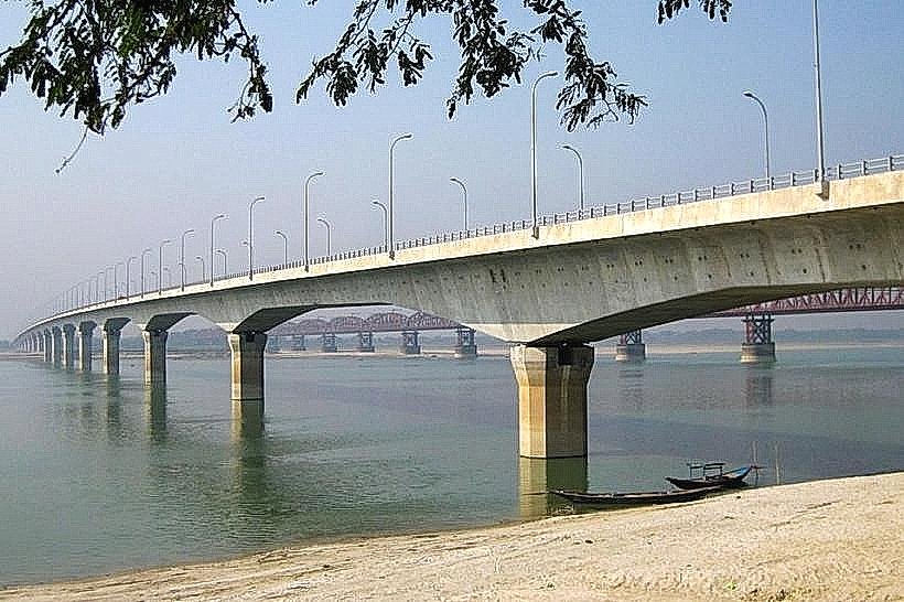
The Hardinge Bridge is a steel truss railway bridge spanning the Padma River in Pabna, Bangladesh. It connects the cities of Pabna and Kushtia.
Visual Characteristics
The bridge consists of 15 main spans and 11 smaller approach spans, totaling 1.8 kilometers (1.1 miles) in length. It is constructed primarily of steel girders and concrete piers. The structure is painted a utilitarian grey and exhibits a robust, industrial design.
Location & Access Logistics
The Hardinge Bridge is situated approximately 15 kilometers (9.3 miles) south of Pabna city center. Access is primarily via National Highway 4 (N4) and then local roads leading to the bridge. Limited parking is available at designated points near the bridge entrances. Public transport options include local buses that run between Pabna and the bridge vicinity, with services generally operating from dawn until dusk.
Historical & Ecological Origin
Construction of the Hardinge Bridge began in 1908 and was completed in 1915. It was designed by Sir Robert McAlpine and built by the British firm Sir John Jackson (1928) Ltd. The bridge's original purpose was to facilitate railway traffic and trade between the eastern and western parts of Bengal, which were then under British rule. The Padma River is a major distributary of the Ganges.
Key Highlights & Activities
Observation of the bridge's engineering and scale is the primary activity. Railway enthusiasts may observe train crossings. Walking or cycling across the bridge is not permitted due to safety regulations. Photography of the structure and river is possible from designated viewing areas.
Infrastructure & Amenities
Restrooms are not consistently available at the immediate bridge site. Shade is minimal, provided only by the bridge structure itself during certain times of day. Cell phone signal (4G/5G) is generally available. Food vendors are typically located in the towns on either side of the bridge, not directly on or adjacent to it.
Best Time to Visit
For photography, early morning or late afternoon offers the most favorable lighting conditions for capturing the bridge's form. The dry season, from November to March, provides the most stable weather. Tidal variations of the Padma River are significant and can impact water levels, but do not directly affect access to the bridge itself.
Facts & Legends
During its construction, the bridge faced significant engineering challenges due to the powerful currents of the Padma River. A local anecdote suggests that the sheer scale of the project was intended to impress the British monarchy, though its primary function was logistical. A specific tip for visitors is to check local train schedules if observing train crossings is a priority.
Nearby Landmarks
- Pabna University of Science and Technology (PUST) - 12km Northeast
- Jor Bangla Temple - 18km East
- Shilaidaha Kuthibari - 25km Southeast
- Ishwardi EPZ - 10km Northwest