Information
Landmark: Pine Ridge TrailCity: Chadron
Country: USA Nebraska
Continent: North America
Pine Ridge Trail, Chadron, USA Nebraska, North America
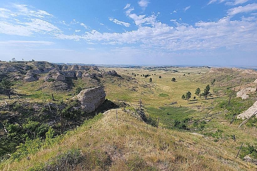
Pine Ridge Trail is a 12.8-mile (20.6 km) loop trail located within the Nebraska National Forest near Chadron, Nebraska. It is primarily used for hiking and horseback riding.
Visual Characteristics
The trail traverses mixed-grass prairie, ponderosa pine forests, and sandstone formations. Elevation changes range from approximately 3,200 feet (975 m) to 3,500 feet (1,067 m). Sandstone outcrops exhibit varied coloration, including tan, red, and gray hues. Tree density varies, with open grasslands interspersed with stands of ponderosa pine and some deciduous trees along drainages.
Location & Access Logistics
The trailhead is located 10 miles north of Chadron, Nebraska, off U.S. Highway 385. Access is via Forest Road 201 (also known as the Toadstool Park Road). The trailhead parking area is unpaved and can accommodate approximately 15 vehicles. No public transport services this location.
Historical & Ecological Origin
The Pine Ridge Trail system follows established game trails and early settler routes through the Pine Ridge Escarpment. The escarpment itself is a geological feature formed by erosion of the Ogallala Formation, dating back millions of years. The area is part of the Nebraska National Forest, established in 1902 to combat deforestation.
Key Highlights & Activities
Hiking the full 12.8-mile loop. Horseback riding is permitted on the designated trail. Observation of diverse flora and fauna, including pronghorn, deer, and various bird species. Photography of geological formations and forest landscapes.
Infrastructure & Amenities
The trailhead has a single information kiosk with a trail map. No restrooms, potable water, or designated picnic areas are available at the trailhead. Cell phone signal is intermittent to non-existent along most of the trail. No food vendors are present at or near the trailhead.
Best Time to Visit
For hiking and horseback riding, late spring (May-June) and early autumn (September-October) offer moderate temperatures. Summer months (July-August) can experience high temperatures exceeding 90°F (32°C). Sunrise and sunset provide optimal lighting conditions for photography of the sandstone formations.
Facts & Legends
The sandstone formations along the trail, particularly in nearby Toadstool Park, are known for their hoodoo-like structures. Local folklore sometimes attributes these formations to ancient giants or spirits. A verified historical fact is that the area was a significant hunting ground for Native American tribes for centuries prior to European settlement.
Nearby Landmarks
- Toadstool Geologic Park (0.5km North)
- Chadron State Park (12km South)
- Museum of the Fur Trade (15km South)
- Scotts Bluff National Monument (80km Southwest)