Information
Landmark: Poulnabrone DolmenCity: Clare
Country: Ireland
Continent: Europe
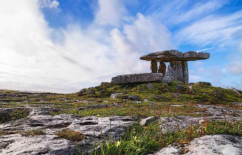
Poulnabrone Dolmen, Clare, Ireland, Europe
Poulnabrone Dolmen is a Neolithic portal tomb located on The Burren limestone plateau in County Clare. It is one of the most photographed and recognized archaeological monuments in Ireland.
Visual Characteristics
The structure is a classic example of portal tomb architecture.
Composition: Consists of a large, thin, $3.6$-meter-long capstone supported by two massive upright portal stones and flanking orthostats.
Orientation: The tomb faces north-south, with the entrance traditionally oriented toward the rising sun at specific times of the year.
The Cairn: The dolmen is surrounded by a low, oval-shaped mound of stones (cairn), which originally helped stabilize the structure and may have been much larger.
Location & Access Logistics
Address: Poulnabrone, Co. Clare, Ireland.
Position: Situated on the R480 road between Ballyvaughan and Kilfenora.
Transit: Accessible primarily by private vehicle or organized tour bus.
Parking: A dedicated public car park is located directly across from the site.
Accessibility: A graveled path leads from the car park to the monument. The path is relatively level, but the area immediately surrounding the dolmen is uneven limestone pavement (clints and grykes), which is a trip hazard.
Historical & Archaeological Origin
Date: Radiocarbon dating of remains found at the site indicates it was in use between $3800$ BC and $3200$ BC.
Excavation: In 1986, a major excavation led by Ann Lynch revealed the remains of approximately 33 individuals (adults and children) buried in the chamber.
Artifacts: Excavations uncovered Neolithic items including stone axes, bone pendants, quartz crystals, and pottery shards, now housed in the National Museum of Ireland.
Key Highlights
Name Origin: The name Poll na mBrón translates from Irish as "Hole of the Quern Stones" or "Hole of the Sorrows."
Landscape Context: The site provides an unobstructed view of the Burren’s karst landscape, demonstrating how Neolithic people utilized the natural limestone plateaus for ritual sites.
Conservation: To protect the site from erosion and collapse, the area immediately around the stones is roped off to prevent visitors from climbing on the monument.
Infrastructure & Amenities
Facilities: The site is an open-air monument. There is no visitor center on-site.
Interpretive Signage: High-quality information boards are located at the path entrance, providing geological and historical context.
Sanitation: There are no public restrooms at the site; the nearest facilities are in Ballyvaughan (8 km) or Kilfenora (9 km).
Connectivity: 4G signal is generally stable but can be weak due to the rural, elevated location.
Technical Details
The capstone is estimated to weigh approximately $1.5$ tons. The tomb was built by wedging the upright stones into the existing grykes (fissures) of the limestone pavement and then levering the capstone into place using earthen ramps that were later removed.
Nearby Landmarks
Caherconnell Stone Fort – 1 km South
Aillwee Cave – 8 km North
Kilfenora (The Burren Centre) – 9 km South
Ballyvaughan – 8 km North