Information
City: KadavuCountry: Fiji
Continent: Australia
Kadavu, Fiji, Australia
Kadavu functions as Fiji's primary southern maritime outpost and a specialized center for subsistence agriculture and eco-tourism. It is situated 100 km south of Viti Levu and is the fourth-largest island in the archipelago, characterized by its proximity to the Great Astrolabe Reef.
Historical Timeline
Kadavu was traditionally governed by independent chiefdoms and was a significant site for early 19th-century whaling operations and bêche-de-mer trading. The formal era of colonial governance began following the 1874 Cession, though its isolation prevented the large-scale plantation development seen on other islands. A significant administrative reconstruction occurred in the mid-20th century with the establishment of Vunisea as the regional capital. The primary event shaping the current urban and logistical form was the 1970s construction of the Vunisea jetty and airstrip, which remains the island's sole high-capacity link to the mainland.
Demographics & Population
The total population of Kadavu is approximately 10,200, distributed across 75 villages. The demographic profile is 99% iTaukei (Indigenous Fijian), with a minimal transient population of international researchers and resort staff. The median age is approximately 23.4 years.
Urban Layout & Key Districts
The island lacks a centralized city, operating through the administrative hub of Vunisea. Vunisea is located at the narrowest part of the island (the Namalata Isthmus), containing the hospital, police station, and airport. The island is divided into nine districts, with the Ono Island group to the northeast serving as the primary hub for marine conservation. The interior is dominated by the volcanic peak of Mount Washington (Nabukelevu) at the western tip.
Top City Landmarks
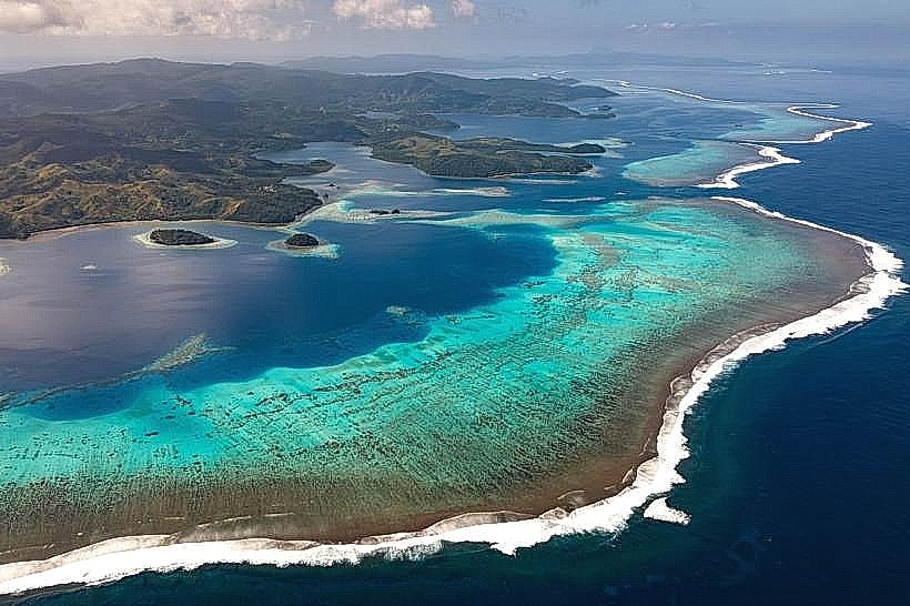
Great Astrolabe Reef: One of the largest barrier reefs in the world, encircling the eastern end of the island.
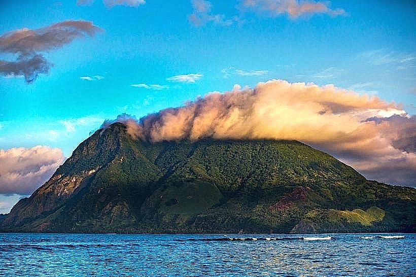
Mount Washington (Nabukelevu): A 805-meter volcanic peak and a designated site for endemic bird species.
Vunisea Jetty: The primary maritime logistical node for the island.
Kavala Bay: A deep-water bay on the northern coast serving as a secondary maritime shelter.
Namalata Isthmus: The geographic "pinch point" where the northern and southern coasts are separated by only several hundred meters.
Transportation Network
Internal movement is conducted almost exclusively via maritime transit in small fiberglass outboard boats. There is no comprehensive road network; a single unsealed road connects Vunisea to nearby villages on the western peninsula. There is no public bus service, metro, or ride-sharing. Official taxis are non-existent; transport is negotiated with private 4WD owners in Vunisea. Aviation access is via Fiji Link flights to Vunisea Airport.
Safety & "Red Zones"
The general safety level is very high. Crime is negligible. Risks are environmental, specifically regarding open-ocean boat travel between the mainland and the outer islands. There are no "red zones." Visitors are cautioned against attempting to hike the interior without local guides due to dense rainforest and lack of marked trails.
Digital & Financial Infrastructure
Internet speeds are low, averaging 5–15 Mbps via satellite or microwave links. Vodafone and Digicel provide 4G coverage in Vunisea, but signal is absent in the southern and eastern coves. Card acceptance is restricted to a few established resorts. There are no banks and only one BSP ATM located in Vunisea, which is frequently out of service or cash; travelers must carry sufficient FJD cash from Suva.
Climate & Air Quality
Kadavu has a tropical rainforest climate with high humidity. Average temperatures range from 22°C to 30°C. Air quality is pristine. The primary weather risk is tropical cyclones, which frequently pass directly over the island, and heavy swells that can suspend all maritime transport for several days.
Culture & Social Norms
Tipping is not traditional. Cultural protocols are strictly conservative. Presentation of kava (sevusevu) to the village headman is mandatory for all visitors entering village lands. Modest dress (sulu) is required. The "Kadavu style" of kava consumption is noted for being highly formal and central to all social and political communal governance.
Accommodation Zones
Vunisea: Recommended for logistics and proximity to the airport and government services.
Ono Island/Eastern Reef: Recommended for maritime access to the Great Astrolabe Reef and eco-resorts.
Local Cost Index
1 Espresso: 9.00 FJD ($4.02 USD) (Available only in resorts)
1 Standard Lunch: 15.00–25.00 FJD ($6.70–$11.15 USD)
1 Boat Transfer (Local): 50.00–150.00 FJD ($22.30–$66.90 USD)
Nearby Day Trips
Galoa Island: Located directly off Vunisea (10-minute boat trip).
Dravuni Island: A northern island within the Great Astrolabe Reef (1-hour boat trip).
Mount Washington Hike: Accessible from western villages (4-hour return trek).
Naigoro Passage: A primary marine biodiversity site in the reef.
Facts & Legends
Kadavu is the exclusive habitat of the Crimson Shining Parrot, a species found nowhere else. Local oral tradition states the island was once much closer to Viti Levu but was pushed south by a legendary hero to protect the inhabitants from mainland wars. Historically, Vunisea was a critical telegraph station in the early 20th century, serving as the first point of contact for ships arriving from the south before reaching Suva.