Information
Landmark: Vunisea VillageCity: Kadavu
Country: Fiji
Continent: Australia
Vunisea Village, Kadavu, Fiji, Australia
Vunisea is the administrative and logistical center of the Kadavu Island group, situated on the Namalata Isthmus at 19.05° South and 178.15° East. It serves as the primary port of entry and the site of the island's only airport.
Visual Characteristics
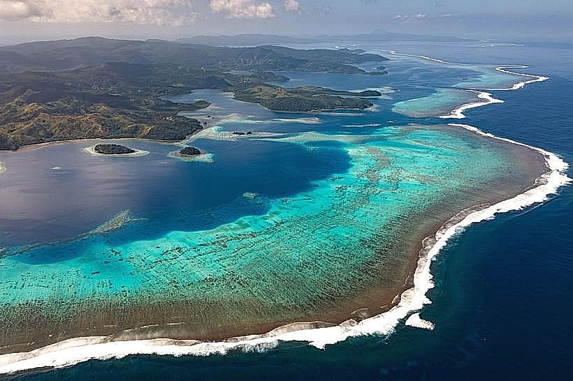
The village is situated on a narrow, low-lying land bridge that separates the Namalata Bay to the north from the Vunisea Bay to the south. The terrain is a mix of coastal flats and moderate volcanic hills. The surrounding environment is dominated by secondary tropical forest, mangroves, and small-scale agricultural plots. The coastline features dark volcanic sand beaches and extensive tidal flats.
Location & Access Logistics
Vunisea is 100 kilometers south of Suva. It is accessed via Vunisea Airport (KDV), which receives daily Twin Otter or ATR-42 flights from Nadi and Suva. A weekly government-subsidized ferry from Suva docks at the Vunisea jetty. As the island's hub, it is the starting point for all boat transfers to resorts on the Great Astrolabe Reef or Ono Island. A gravel road extends east from Vunisea to the village of Kavala, providing the only significant vehicular transit route on the island.
Historical & Ecological Origin
The Namalata Isthmus was historically used as a "waru" (canoe drag), where seafarers pulled vessels across the narrow land strip to avoid circumnavigating the southern tip of the island. In the colonial era, Vunisea was established as a government outpost due to its central location and sheltered harbors. The area remains an ecological transit zone for the endemic Kadavu Musk Parrot, which can frequently be observed in the large trees surrounding the government station.
Key Highlights & Activities
Logistics and administration are the primary functions. Visitors utilize Vunisea for the post office, police station, and the main island hospital. The Vunisea market is a central point for purchasing local produce and kava. Hiking is possible on the adjacent hills for views of both northern and southern bays. The jetty area serves as a transit point for snorkeling trips to the nearby Namalata Reef.
Infrastructure & Amenities
Vunisea contains the most robust infrastructure in the archipelago. It hosts the Kadavu Provincial Hospital, a police station, a post office, and a branch of the Westpac or BSP bank (availability varies; ATMs are often unreliable). Electricity is provided by a localized diesel-generator grid, and water is sourced from the nearby Nabukelevu catchment. 4G cell signal is stable and serves as the primary transmitter for the region. Small grocery canteens provide basic supplies, but there are no large supermarkets.
Best Time to Visit
The dry season from May to October is optimal for travel, as flight cancellations due to weather are less frequent. The village is most active on "Flight Days" and when the weekly ferry arrives. Photography is best in the early morning at the Namalata Bay side to capture the sunrise over the water, or at the airstrip during the afternoon when the light highlights the volcanic ridges to the west.
Facts & Legends
A historical oddity is that the Vunisea airstrip was constructed during World War II as an emergency landing ground but saw little action until its redevelopment for civil aviation. Local tradition holds that the isthmus is a "place of crossing," and travelers are expected to show respect when transiting the traditional canoe paths.
Nearby Landmarks
Vunisea Airport – 0.5km West
Namalata Bay – 0.2km North
Vunisea Hospital – 0.3km East
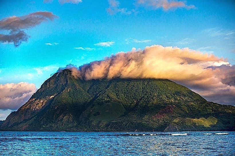
Mount Washington (Nabukelevu) – 24.0km West
Namalata Reef – 2.0km Northwest