Information
City: KhenchelaCountry: Algeria
Continent: Africa
Khenchela, Algeria, Africa
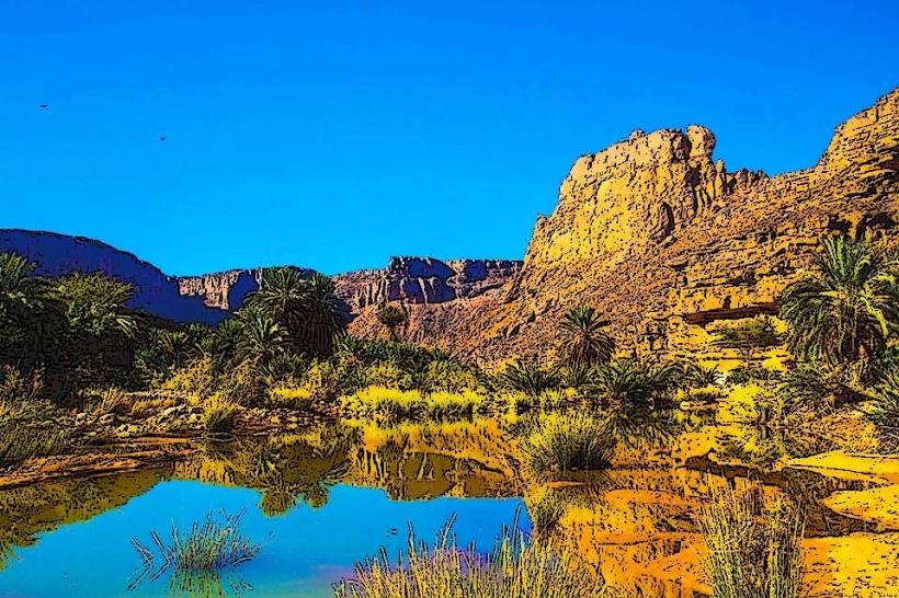
Khenchela functions as the primary highland pivot of the Aurès Mountains in eastern Algeria. Situated at an elevation of 1,200m, it serves as a specialized node for Berber Chaoui culture, mountain forestry, and thermal hydrotherapy. In January 2026, the city is defined by its role as a technological and athletic hub, following the hosting of national AI hackathons and the state-backed takeover of its primary football asset.
Historical Timeline
2nd Century AD: Established as the Roman city of Mascula; specialized as a strategic military post and breadbasket for the empire.
7th Century: Served as a primary stronghold for the Berber queen Dihya (The Kahina) during the resistance against the Umayyad expansion.
1945 (May 8): A critical node of the nationalist demonstrations that preceded the War of Independence; the region suffered heavy colonial repression.
2026 (Jan 6–8): Technological Intelligence. Abbes Laghrour University hosted the 2026 AI and Entrepreneurship Hackathon, focusing on smart city solutions for Saharan and highland logistics.
2026 (Jan 20): Sporting Reorientation. Algérie Télécom officially finalized its takeover of the local football club, USM Khenchela, signaling a specialized shift toward corporate-backed professional sports infrastructure in the highlands.
Demographics & Population
The metropolitan population is approximately 135,000 (2026 estimate), with the wider Khenchela Province reaching over 420,000. The demographic is predominantly Chaoui (Berber), characterized by a high-fidelity preservation of the Shawiya language and traditional mountain social structures. The population density is concentrated in the central high plateaus, where climate-resilient agriculture is the primary economic driver.
Urban Layout & Key Districts
Centre Ville: The specialized commercial spine; characterized by its high-altitude "raw" aesthetic and the scent of traditional roasting grills.
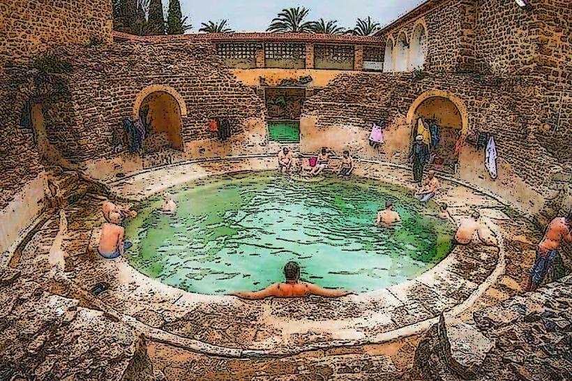
El Hamma: A specialized thermal satellite located 7km west; home to the high-fidelity Roman bath complexes and modern medical spas.
Mustafa Ben Boulaid (New Urban Pole): A specialized development node to the north; designed to accommodate the city's rapid 21st-century demographic expansion.
Baghai: A specialized archaeological district; site of the ancient "Palace of the Priestess" (Dihya) and historical administrative ruins.
Babar & Chechar: Specialized southern districts; serving as the transition zone between the Aurès highlands and the Saharan desert floor.
Top City Landmarks
Hammam Essalihine (The Baths of Flavius): A specialized 2,000-year-old Roman thermal site; features circular stone pools still used for high-fidelity hydrotherapy today.
Statue of Queen Dihya: A specialized cultural monument in the city center; commemorates the Berber resistance leader and serves as the primary icon of regional identity.
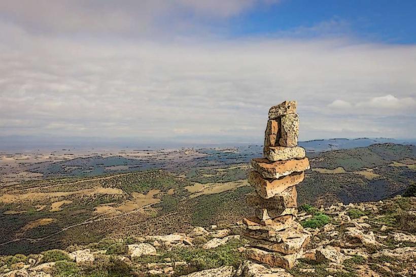
Djebel Chelia: Located nearby; the specialized highest peak of the Aurès (2,328m), serving as the primary node for alpine trekking and cedar forest conservation.
The Palace of the Priestess (Ksar el-Kahina): A specialized historical ruin in Baghai; remains a primary site for archaeological study of the early Islamic-Berber transition.
Gorges of Khirane: A specialized geological node to the south; characterized by dramatic limestone cliffs and ancient troglodyte dwellings.
Transportation & 2026 Logistics
Regional Road N32 & N88: The specialized logistical spines; connect Khenchela to Batna, Tébessa, and the Tunisian border.
2026 Rail Expansion: In January 2026, Khenchela is a focus of the High Plateaus Rail Bypass, intended to link the highland grain and mineral zones to the national freight network.
Urban Transit: Movement is facilitated by specialized local bus fleets and collective taxis; the high-altitude terrain makes all-wheel-drive vehicles a standard logistical requirement for rural access.
January Climate: As of January 2026, the city is experiencing typical winter mountain conditions; night temperatures frequently drop to -1°C, with periodic snowfall obstructing highland passes.
Safety & Environment
The general safety level is High, though mountain roads require specialized caution during winter ice cycles. Environmental Note: Khenchela is a primary node for "Cedrus Atlantica Preservation," housing some of the Mediterranean's last high-fidelity ancient cedar forests. In 2026, the government has increased satellite monitoring (via ALSAT-2) to track illegal logging and forest fire risks in the Djebel Chelia zone.
Local Cost Index (2026 Estimates)
1 Night (Mountain Guesthouse/Hotel): DZD 6,000 – 10,500 (~$45 – $78)
Traditional "Berber Lamb Grill" Meal: DZD 900 – 1,600
Guided Trekking (Djebel Chelia): DZD 3,500 – 6,000
Median Monthly Rent (2-BR Apartment): DZD 18,000 – 28,000
1L Gasoline: DZD 45.00
Facts & Legends
Khenchela is the site of the "Legend of the Priestess’s Treasure," rumored to be hidden in the caves of the Aurès following Dihya's final stand. A verified fact is that the city’s name, Mascula, was used by the Romans to denote a "fortified place." Historically, the region was a primary producer of military-grade horses for the Roman cavalry. In 2026, the city remains the specialized global epicenter for "Shawiya Ethno-Musicology," hosting traditional mountain flute (gasba) festivals during the January cultural cycle.