Information
City: Le MorneCountry: Mauritius
Continent: Africa
Le Morne, Mauritius, Africa
Le Morne serves as a primary cultural and adventure tourism hub in the Black River District on the southwestern tip of Mauritius. It functions as a global site for kitesurfing and is home to the island's most significant UNESCO World Heritage site, centered on the Le Morne Brabant Mountain.
Historical Timeline
The area became a sanctuary for maroons (escaped slaves) during the 18th and early 19th centuries, who utilized the mountain’s inaccessible cliffs as a defensive stronghold. The primary event shaping the current urban form was the 2008 designation of Le Morne Brabant as a UNESCO World Heritage Site, which halted large-scale commercial development on the mountain and preserved the surrounding "buffer zone" for eco-sensitive tourism and artisanal fishing.
Demographics & Population
The village of Le Morne has a permanent population of approximately 1,300. The demographic profile is predominantly Creole (of Malagasy and African descent), with a small percentage of European expatriates. The median age is 35 years.
Urban Layout & Key Districts
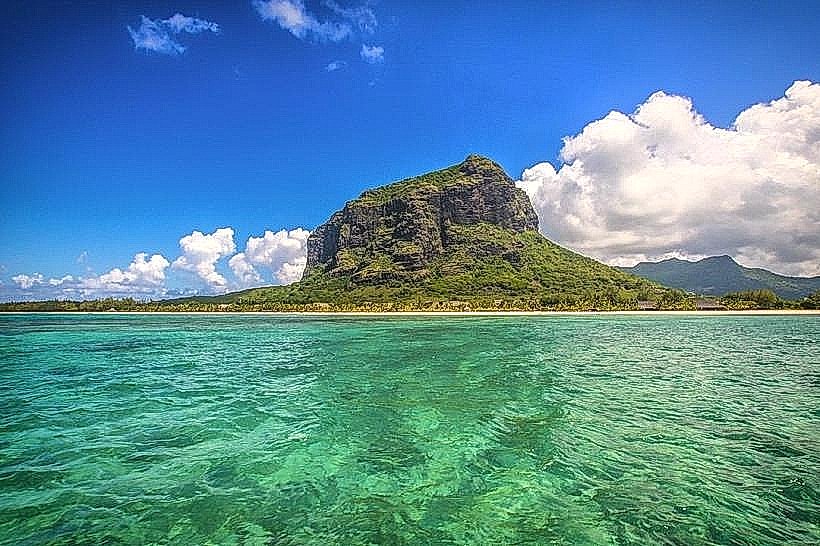
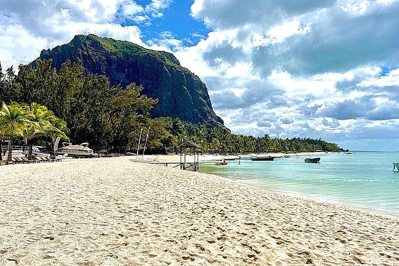
The area is a peninsula dominated by the 556-meter basaltic monolith. Key districts include Le Morne Village (North), a traditional residential and fishing settlement; the Resort Zone (West/South), featuring a strip of luxury beachfront hotels; and the Kite Lagoon (Southwest), a specialized zone for international water sports.
Top City Landmarks
Le Morne Brabant Mountain
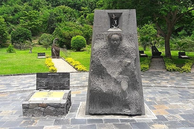
International Slave Route Monument
One Eye (Famous surf break)
Le Morne Public Beach
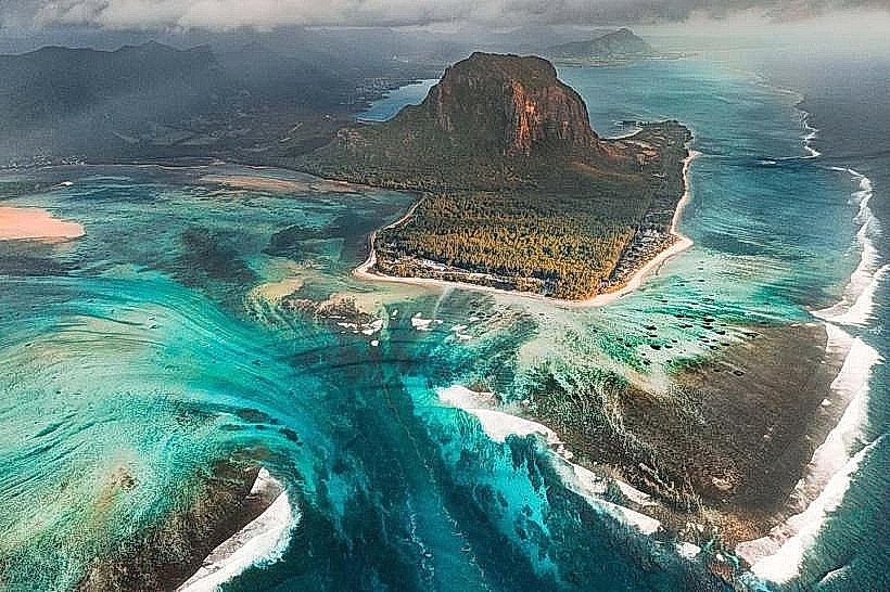
Underwater Waterfall (Visual illusion off the coast)
Transportation Network
Movement requires a private vehicle or taxi; there is no Metro Express. A coastal bus line connects the village to Baie du Cap and Choisy. Ride-sharing via Yugo is available but unreliable due to the remote location. Official taxis are white with yellow markings, primarily stationed at resort entrances. Traffic is light, consisting mainly of tourist vehicles and local fishing boats.
Safety & "Red Zones"
The safety level is high. Avoid hiking the mountain without a certified guide, as the upper sections involve technical scrambling and are dangerous in wet conditions. Do not swim at the "One Eye" point due to extreme currents and sharp reef. Common scams are limited to unlicensed hiking "guides" and inflated prices for boat trips to the Benitiers Island.
Digital & Financial Infrastructure
Average internet speed is 30-50 Mbps. Main carriers are my.t and Emtel. Card acceptance is universal in resorts but non-existent in the village "tabagies" and small eateries. There are no ATMs on the peninsula; the nearest are in La Gaulette (8 km away).
Climate & Air Quality
Temperatures range from 18°C to 25°C in winter and 23°C to 31°C in summer. The peninsula is extremely windy, particularly from May to October, due to the acceleration of trade winds around the mountain. Air quality is exceptional, consistently ranking among the best on the island.
Culture & Social Norms
Tipping of 10% is standard in restaurants. Handshakes are the common greeting. The area is highly respectful of its history; loud music and disrespectful behavior are prohibited near the Slave Route Monument. Dress code is casual, but modest attire is expected when walking through the residential village.
Accommodation Zones
Stay in the Resort Strip for luxury beach access and managed security.
Stay in the nearby village of La Gaulette (10 minutes North) for budget-friendly apartments and proximity to supermarkets.
Local Cost Index
1 Espresso: 125 MUR ($2.75 USD)
1 Standard Lunch (Village Cafe): 350 MUR ($7.65 USD)
1 Bus Ticket: 35 MUR ($0.75 USD)
Nearby Day Trips
Île aux Benitiers: 2 km (15-minute boat ride)
Chamarel Seven Coloured Earth: 14 km (25 minutes)
Black River Gorges (Gorges Viewpoint): 20 km (35 minutes)
Baie du Cap Macondé: 10 km (15 minutes)
Facts & Legends
Local legend states that when slavery was abolished in 1835, a police expedition was sent to the mountain to inform the maroons they were free; however, fearing they were being recaptured, many leaped to their deaths from the cliffs. A verified historical oddity is the "Underwater Waterfall," which is not a waterfall but a visual illusion created by sand and silt deposits sliding down an offshore oceanic shelf.