Information
City: PedernalesCountry: Dominican Republic
Continent: North America
Pedernales, Dominican Republic, North America
Pedernales is the capital of the Pedernales Province, located on the far southwestern border with Haiti. It is the most remote provincial capital in the Dominican Republic and serves as the gateway to the Jaragua National Park. Currently, it is the focus of a multi-billion dollar government development project aimed at turning the region into a sustainable luxury tourism destination.
Historical Timeline
The town was officially founded in 1927 as part of a state effort to populate the border region. Historically, its economy was based on bauxite mining and small-scale fishing. In the mid-20th century, the Alcoa Exploration Company operated massive aluminum ore mines in the nearby Sierra de Bahoruco. The most significant modern event is the ongoing Cabo Rojo Master Plan, which began construction in 2023 to build international hotels and a cruise port (Port Cabo Rojo).
Demographics & Population
The population is approximately 15,000. It is a frontier town with a high level of cross-border interaction. The demographic is primarily Dominican, with a significant Haitian population involved in trade and construction. The social atmosphere is quiet and rustic compared to the rest of the country.
Urban Layout & Key Districts
The town is built on a simple grid layout ending abruptly at the Pedernales River, which marks the international border.
The Town Center: A modest area with small guesthouses and local eateries.
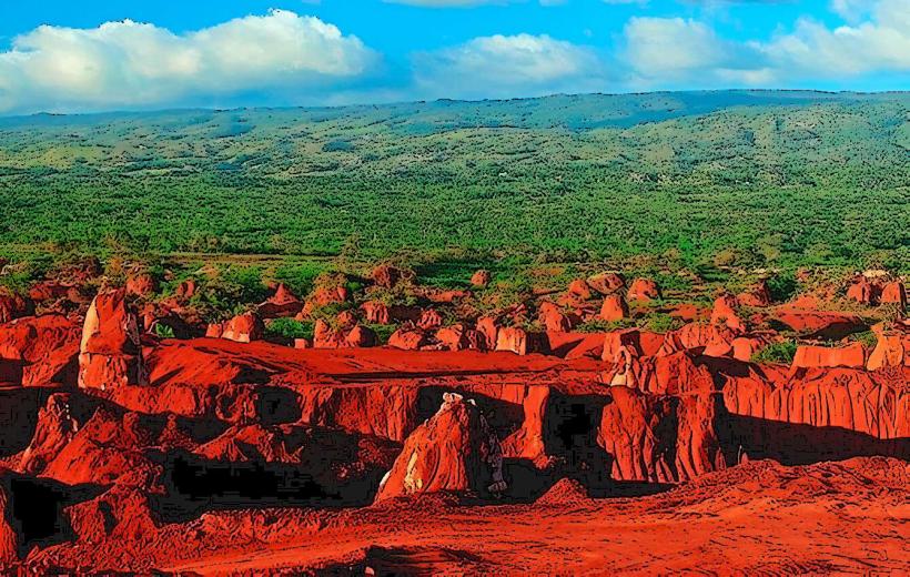
Cabo Rojo: Located 20 minutes south of the town, this is the industrial-turned-tourist zone featuring the new cruise port and reddish bauxite-stained earth.
Las Mercedes: A high-altitude agricultural community in the mountains north of the town.
Top Landmarks
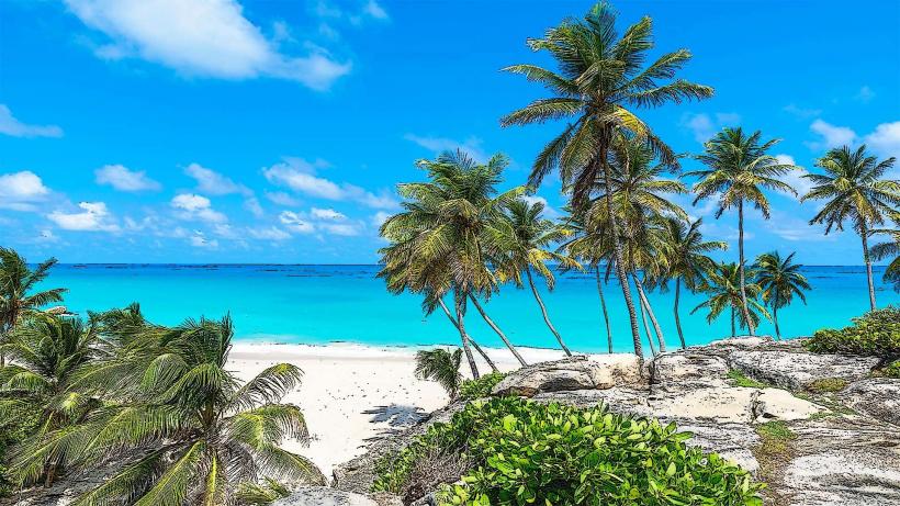
Bahía de las Águilas: Widely considered the most beautiful beach in the country; a 10 km stretch of pristine white sand and crystal water with no permanent structures.
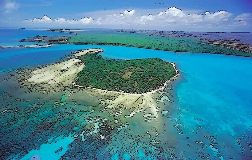
Jaragua National Park: A UNESCO Biosphere Reserve and the largest protected area in the Caribbean, featuring diverse birdlife and ancient caves.
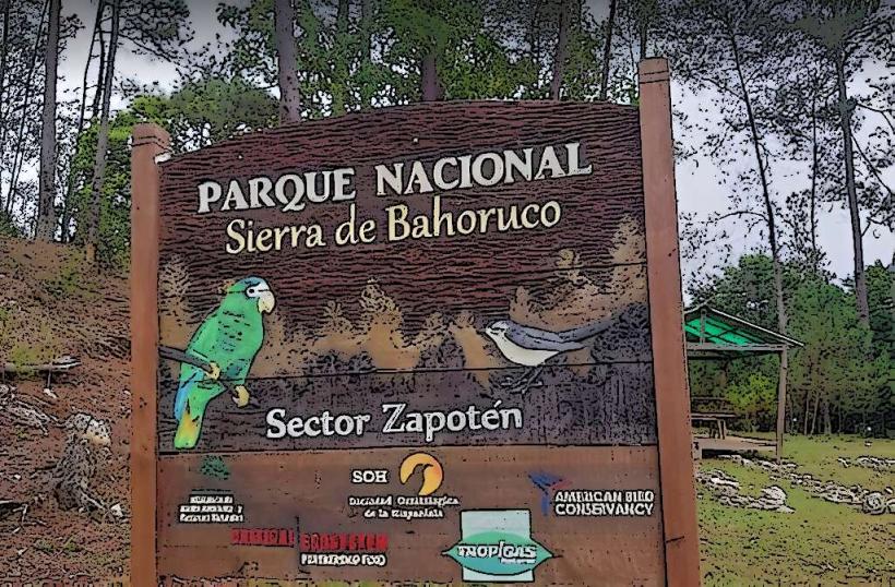
Hoyo de Pelempito: A geological depression in the Sierra de Bahoruco dropping 700 meters, offering a distinct cool climate and pine forests.
Laguna de Oviedo: A hypersaline lake with a permanent colony of flamingos and several keys inhabited by iguanas.
Pedernales River: The natural border with Haiti, where locals from both nations interact at the international bridge.
Transportation Network
Roads: Reached via the Carretera Sánchez (Hwy 2). It is a 5–6 hour drive from Santo Domingo. The road is scenic but remote; ensure a full fuel tank before leaving Barahona.
Public Transit: Caribe Tours operates daily buses from Santo Domingo. Within town, motoconchos are the primary mode.
Air: Cabo Rojo Domestic Airport (CBJ) handles charter flights. A new international airport is currently under construction to support the tourism expansion.
Sea: Small boats (yolas) transport tourists from Cabo Rojo to Bahía de las Águilas.
Safety & "Red Zones"
Pedernales is very safe for tourists, with a lower violent crime rate than the capital.
Risks: Environmental hazards like extreme dehydration, sunstroke, and lack of mechanical support on remote roads.
Border Caution: Do not attempt to cross the border into Haiti outside of official channels at the Pedernales bridge. Be aware of the bi-national market days (Mondays and Fridays) when the town becomes extremely crowded.
Digital & Financial Infrastructure
4G mobile coverage is reliable in the town center but non-existent in Bahía de las Águilas or the deep national park. Wi-Fi is limited to specific guesthouses. There are very few ATMs (primarily Banreservas); it is highly recommended to carry sufficient cash (DOP).
Climate & Air Quality
Climate: Arid and hot. It is one of the driest places in the country. Daytime temperatures consistently reach 32°C–34°C.
Air Quality: Exceptional, due to the total absence of heavy industry and the low population density.
Culture & Social Norms
The culture is characterized by "frontier stoicism." It is less commercialized than any other part of the country.
Cuisine: Specialized in Langosta (lobster) and Lambí (conch), which are local staples.
Sustainability: There is a strong local emphasis on preserving the "virgin" state of the beaches.
Accommodation Zones
Town Center: Best for budget guesthouses and local dining.
Cabo Rojo/Glamping: Best for direct access to Bahía de las Águilas; several "glamping" sites operate on the beach.
Local Cost Index
1 Espresso: $RD 100 ($1.70)
1 Whole Fried Fish: $RD 600 ($10.15)
1 Boat to Bahía de las Águilas: $RD 3,000 ($50.00 per boat)
Nearby Day Trips
Anse-à-Pitre, Haiti: The town directly across the border bridge (requires passport and visa/permit).
Mulito River: A crystal-clear freshwater river in the mountains near the town.
Facts & Legends
A verified historical oddity is that the red color of the soil in Cabo Rojo is due to high concentrations of aluminum and iron oxide, a remnant of the region's mining past. Local legend speaks of the "Boas of Jaragua," massive snakes rumored to live in the deep limestone caves of the national park, guarding ancient Taino treasures.