Information
City: SigatokaCountry: Fiji
Continent: Australia
Sigatoka, Fiji, Australia
Sigatoka serves as the principal urban center for the Nadroga-Navosa Province and functions as the primary logistical hub for Fiji's "Salad Bowl," the fertile Sigatoka Valley. It is situated on the southwestern coast of Viti Levu at the mouth of the Sigatoka River, approximately 61 km south of Nadi.
Historical Timeline
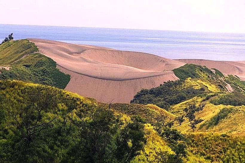
The area surrounding Sigatoka contains the earliest evidence of human habitation in Fiji, with the Lapita people settling the dunes circa 1000 BCE. The modern town was formally established as a center for the sugarcane industry in the early 20th century. The primary event shaping the current urban form was the construction of the Sigatoka Bridge in 1923 (and its subsequent 2016 replacement), which facilitated the movement of agricultural goods from the interior valley to the coastal processing zones and Nadi.
Demographics & Population
The total population within the town limits is approximately 10,500. The broader Sigatoka Valley and coastal corridor support a population of roughly 53,000. The demographics consist of approximately 52% iTaukei (Indigenous Fijian), 43% Indo-Fijian, and 5% other ethnicities. The median age is approximately 28 years.
Urban Layout & Key Districts
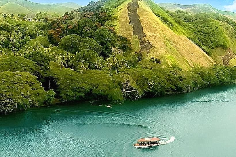
The town is bisected by the Sigatoka River and organized along the Queens Road. The Central Business District (CBD) is concentrated on the eastern bank of the river. The Sigatoka Valley Road extends north into the interior, serving as the artery for the agricultural districts. The Coral Coast, beginning 2 km south of the town, contains the primary tourism and resort infrastructure.
Top City Landmarks
Sigatoka Sand Dunes National Park: Fiji’s first national park, protecting an extensive dune system and Lapita archaeological sites.
Kula Wild Adventure Park: An ecological preserve and captive breeding center for indigenous Fijian species.
Tavuni Hill Fort: A semi-restored 18th-century Tongan defensive fortification overlooking the river.
Sigatoka Market: A high-volume transit point for agricultural produce from the interior.
St. Joan of Arc Church: A prominent mid-century architectural site located near the town center.
Transportation Network
Movement within the town is restricted to buses, taxis, and private vehicles. Taxis are white and utilize meters, with the main stand located at the bus terminal. Minibuses and carriers (open-back trucks) are the primary mode of transport for residents of the Sigatoka Valley. Traffic density is high at the bridge crossing during early morning and late afternoon agricultural transport hours.
Safety & "Red Zones"
The general safety level is high. Risks are primarily limited to petty theft in the crowded market area on Saturdays. There are no specific "red zones" or prohibited neighborhoods, though walking along the Queens Road outside the town lights at night is discouraged due to lack of pedestrian infrastructure and stray livestock.
Digital & Financial Infrastructure
Internet speeds average 15–25 Mbps. Mobile coverage from Vodafone and Digicel is reliable in the town but degrades significantly 10 km into the Sigatoka Valley. Card acceptance is standard in pharmacies and supermarkets but non-existent in the produce market. ATMs (Westpac, BSP, ANZ) are concentrated on the main street of the CBD.
Climate & Air Quality
Sigatoka has a tropical climate with a distinct "dry" side influence. Daytime temperatures range from 25°C in July to 30°C in January. Air quality is exceptionally high due to coastal trade winds and lack of heavy industry. The primary weather risk is river flooding during the monsoon season (December–April), which can temporarily sever the main transport links to the valley.
Culture & Social Norms
Tipping is not required. The region is known for the "Nadroga style" of hospitality, which is traditionally more informal than Suva. Conservative dress is required when visiting the Tavuni Hill Fort or nearby villages. It is considered disrespectful to wear hats or sunglasses when entering a village or any communal gathering space.
Accommodation Zones
The Coral Coast (South): Recommended for proximity to beaches and international dining infrastructure.
Sigatoka CBD: Recommended for logistical proximity to the bus station and valley transport.
Local Cost Index
1 Espresso: 6.00 FJD ($2.68 USD)
1 Standard Lunch: 8.00–15.00 FJD ($3.57–$6.70 USD)
1 Bus Ticket (Local): 1.15 FJD ($0.51 USD)
Nearby Day Trips
Naihehe Cannibal Cave: 35 km (1-hour drive, requires 4WD).
Lawai Pottery Village: 4 km (10-minute drive).
Natadola Beach: 45 km (50-minute drive).
Biausevu Waterfall: 25 km (35-minute drive).
Facts & Legends
According to local oral tradition, the Sigatoka Sand Dunes were formed by the remnants of a great tidal wave sent by a disgruntled sea god to bury a village that had failed to offer the proper tribute. Historically, the Sigatoka Valley was the last stronghold of the "mountain people" during the colonial wars of the 1870s; the rugged terrain allowed them to resist British and coastal Fijian forces longer than any other region on Viti Levu.