Information
Landmark: Avenue of the BaobabsCity: Morondava
Country: Madagascar
Continent: Africa
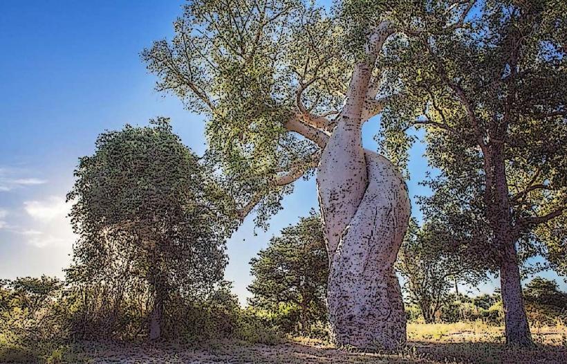
Avenue of the Baobabs, Morondava, Madagascar, Africa
Visual Characteristics
The avenue features dozens of Adansonia grandidieri trees, some reaching heights of up to 30 meters. Their trunks are smooth, cylindrical, and greyish-red, often appearing swollen. The branches are sparse and primarily concentrated at the very top, resembling roots reaching into the sky. The surrounding landscape is semi-arid, characterized by dry scrubland and red laterite soil.
Location & Access Logistics
The site is situated along the RN8 dirt road, connecting Morondava to Belo-sur-Tsiribihina. From Morondava city center, it is approximately a 45-minute drive. Access is typically via private taxi, rented 4x4 vehicle, or organized tour. Parking is available along the roadside near the main cluster of trees. Public transport options are limited to shared bush taxis (taxi-brousse) which may drop off passengers at the main road junction, requiring a walk.
Historical & Ecological Origin
The Avenue of the Baobabs is an ecological remnant of dense tropical forests that once thrived in Madagascar. The Adansonia grandidieri species is endemic to Madagascar. The baobab trees were part of a larger forest, but as the human population grew, forests were cleared for agriculture, leaving the baobabs standing due to their resilience and cultural significance, as well as the difficulty in felling them.
Key Highlights & Activities
Visitors can walk along the dirt road to observe the baobab trees. Photography, particularly during sunrise and sunset, is a primary activity. Local vendors often sell handicrafts and refreshments.
Infrastructure & Amenities
Basic restroom facilities may be available from local vendors or small establishments near the site. There is minimal natural shade directly under the trees due to their sparse canopy. Cell phone signal (4G) is generally available but can be intermittent. Small, informal food and drink vendors are present, especially during peak visiting hours.
Best Time to Visit
The best time for photography is during sunrise or sunset, when the low-angle light illuminates the tree trunks with warm hues. The dry season, from May to October, offers the most favorable weather conditions with less rain and cooler temperatures.
Facts & Legends
The baobab trees are often referred to as "upside-down trees" due to their root-like branches. Local Malagasy folklore suggests that the trees were planted upside down by a mischievous spirit. The Baobab Amoureux (Lovers' Baobab), two intertwined baobab trees, is located a few kilometers from the main avenue and is a popular spot for local legends of eternal love.
Nearby Landmarks
- Baobab Amoureux: 7km North-East
- Sacred Baobab: 8km North-East
- Local Craft Stalls (informal market): 0.1km along the Avenue