Information
Landmark: Tsingy de Bemaraha National ParkCity: Morondava
Country: Madagascar
Continent: Africa
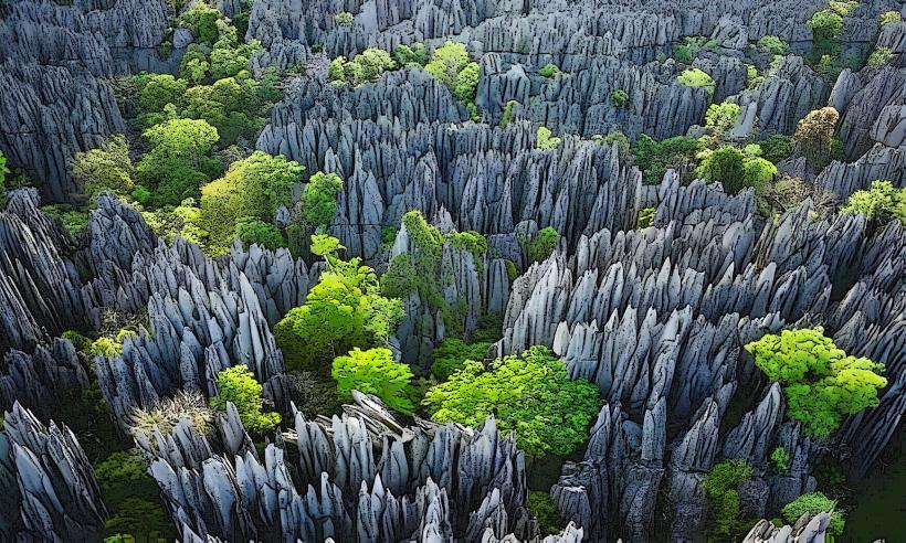
Tsingy de Bemaraha National Park, Morondava, Madagascar, Africa
Visual Characteristics
The park's dominant feature is its labyrinthine formation of sharp, needle-like limestone pinnacles, known as tsingy. These formations are greyish-white, often reaching heights of 50 to 100 meters. Deep canyons and gorges cut through the landscape, contrasting with plateaus and areas of dry deciduous forest. The Manambolo River flows through a significant gorge within the park, featuring caves and underground rivers.
Location & Access Logistics
Access to Tsingy de Bemaraha National Park is primarily from Morondava. The journey involves traveling approximately 150 kilometers north on the unpaved Route Nationale 8 (RN8), which requires a 4x4 vehicle. The trip typically takes 8-12 hours due to road conditions and two river crossings by ferry: the Tsiribihina River and the Manambolo River. Parking is available at the park's main access village, Bekopaka. There are no direct public transport options; private vehicle hire is necessary.
Historical & Ecological Origin
The tsingy formations are a result of karst topography, formed over millions of years. Limestone bedrock was uplifted from the seabed, then eroded by rainwater, creating a network of sharp pinnacles, deep canyons, and caves. Ecologically, the park encompasses diverse habitats including dry deciduous forest, wetlands, and mangrove areas, supporting a high level of endemism in its flora and fauna.
Key Highlights & Activities
- Hiking and climbing on designated routes through the Grand Tsingy and Petit Tsingy.
- Traversing suspension bridges and via ferrata sections for panoramic views of the pinnacles.
- Pirogue or canoe trips along the Manambolo River Gorge, exploring caves and observing wildlife.
- Wildlife observation, including various lemur species (e.g., Decken's sifaka) and endemic birds.
- Exploring specific cave systems such as Anjohin'ny Kivalo Cave.
Infrastructure & Amenities
Restrooms are available at the park entrances and at specific points along the main trails. Shade is limited in the open tsingy areas but can be found within canyons and forested sections. Cell phone signal (4G/5G) is generally poor or non-existent within the park boundaries, with limited connectivity in Bekopaka village. Basic restaurants and guesthouses are present in Bekopaka, serving as the primary base for visitors; no food vendors operate inside the park itself.
Best Time to Visit
The optimal time to visit is during the dry season, from May to October. During this period, roads are passable, and weather conditions are favorable for hiking. The park is generally inaccessible during the rainy season (November to April). For photography, early morning or late afternoon light provides softer illumination and enhances the dramatic shadows of the tsingy formations.
Facts & Legends
The Malagasy word "Tsingy" translates to "where one cannot walk barefoot," accurately describing the razor-sharp nature of the limestone formations. Visitors are required to wear sturdy hiking boots and often harnesses for safety on the more challenging routes.
Nearby Landmarks
- Manambolo River Gorge: 0km (part of the park, accessible from Bekopaka)
- Bekopaka Village: 0km (main access point and accommodation hub)
- Petit Tsingy: 1km East (smaller, more accessible tsingy formations)
- Anjohin'ny Kivalo Cave: 2km South (a notable cave system within the park)
- Grand Tsingy: 10km North (extensive, more challenging tsingy formations)