Information
Landmark: Lily WaterfallCity: Antananarivo
Country: Madagascar
Continent: Africa
Lily Waterfall, Antananarivo, Madagascar, Africa
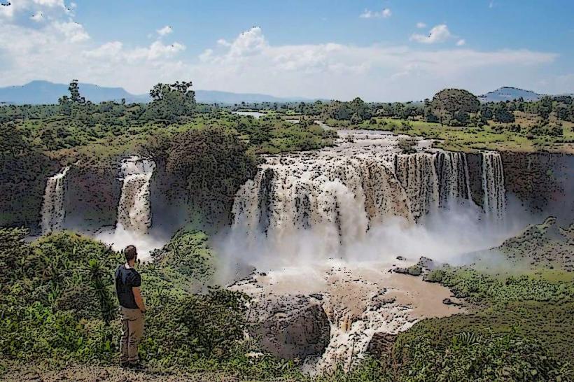
Lily Waterfall is a multi-tiered natural cascade located approximately 70 kilometers south of Antananarivo, Madagascar, situated near the town of Ambatolampy. It is a significant natural feature in the central highlands region.
Visual Characteristics
The waterfall consists of several distinct drops over dark, volcanic rock formations, creating a series of pools at various levels. The water is typically clear, especially during the dry season, and flows through a gorge carved into the surrounding landscape. Dense, tropical vegetation, including ferns and various trees, covers the adjacent cliffs and riverbanks, contributing to a lush, green environment. The total height of the cascade system is estimated to be around 20-30 meters.Location & Access Logistics
Lily Waterfall is accessed via the Route Nationale 7 (RN7) from Antananarivo, heading south towards Ambatolampy. The drive from Antananarivo typically takes 2-3 hours. Approximately 10-15 kilometers before reaching Ambatolampy, a turn-off leads onto an unpaved, often rough, track for several kilometers to the waterfall site. A 4x4 vehicle is recommended, especially during the rainy season. Informal parking is available near the entrance point. Public transport involves taking a taxi-brousse to Ambatolampy, then arranging a local taxi or guide for the final segment to the falls, as direct public transport to the waterfall is not available.Historical & Ecological Origin
The waterfall's formation is primarily geological, resulting from the erosion of volcanic rock layers by the Lily River over millennia. The surrounding landscape is characterized by the high plateau of Madagascar, featuring ancient volcanic activity and subsequent fluvial processes that have shaped the terrain. The area falls within the ecological classification of Madagascar's central highlands, known for its unique biodiversity and relict forest patches.Key Highlights & Activities
Viewing the cascade from various vantage points is the primary activity. Photography of the multi-tiered falls and surrounding greenery is popular. Visitors can engage in short hikes along designated paths to access different levels of the waterfall. Picnicking is possible in shaded areas near the river. During periods of lower water flow, swimming in some of the natural pools may be possible, though caution is advised.Infrastructure & Amenities
Infrastructure at Lily Waterfall is minimal. There are no formal restrooms; visitors should plan accordingly. Natural shade is provided by the surrounding trees. Cell phone signal (4G/5G) can be intermittent or weak in the immediate vicinity of the falls. There are no permanent food vendors or shops directly at the site, so bringing provisions is necessary. Local vendors may occasionally sell snacks or drinks near the access point.Best Time to Visit
The best time to visit for optimal water flow is during or immediately after the rainy season, from November to April, when the falls are at their fullest. However, road access can be challenging during this period. The dry season, from May to October, offers easier access with more stable road conditions, though the water flow may be reduced. For photography, late morning to early afternoon provides good lighting conditions, illuminating the falls without harsh shadows.Facts & Legends
Local folklore sometimes associates the waterfall with spirits or ancient rituals, reflecting the deep cultural connection many Malagasy people have with natural sites. A practical tip for visitors is to hire a local guide from Ambatolampy; they can navigate the access roads, provide insights into the area, and ensure a smoother visit.Nearby Landmarks
- Ambatolampy Town Center: Approximately 12km South-West.
- Ankazomanga Village: Approximately 3km North-East.
- Ambohimanga Sud Village: Approximately 4km South.