Information
Landmark: Mahavavy RiverCity: Toamasina
Country: Madagascar
Continent: Africa
Mahavavy River, Toamasina, Madagascar, Africa
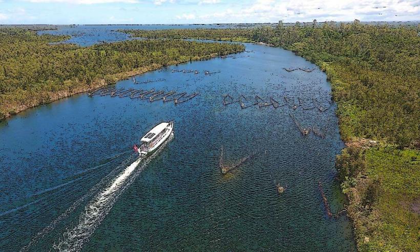
The Mahavavy River is a major river in northwestern Madagascar, originating in the Tsaratanana Massif and emptying into Bombetoka Bay. It is located approximately 600 kilometers northwest of Toamasina.
Visual Characteristics
The river is characterized by its wide, often turbid, brownish waters, especially during the rainy season, due to sediment load. Its banks are predominantly lined with dense mangrove forests as it approaches the coast and delta, transitioning to savanna and agricultural land further upstream. The river's width varies significantly, reaching several kilometers in its lower deltaic sections.
Location & Access Logistics
The Mahavavy River is situated in the Boeny Region of northwestern Madagascar, with its mouth at Bombetoka Bay, approximately 50 kilometers north of Mahajanga. Direct access from Toamasina is not practical due to the significant geographical distance (over 600 km) and lack of direct road connections. From Mahajanga, access points are primarily via Route Nationale 4 (RN4) northwards, with various local dirt roads leading to river crossings or villages along the banks. Parking is informal along river access points. Public transport options are limited to bush taxis (taxi-brousse) from Mahajanga traveling towards Ambanja, which can drop passengers near river-adjacent communities.
Historical & Ecological Origin
The Mahavavy River is a natural hydrological feature, formed by the confluence of several tributaries originating in the Tsaratanana Massif. Its ecological significance lies in its extensive delta and estuary, which form part of the Bombetoka Bay ecosystem, a critical habitat for mangroves, fish, and migratory birds. The river's course has shaped the alluvial plains of the Boeny Region, supporting diverse flora and fauna.
Key Highlights & Activities
Boat trips are possible along sections of the river, particularly near its mouth, offering views of the mangrove ecosystems. Fishing is a primary activity for local communities and can be observed. Birdwatching is a notable activity, with opportunities to spot various waterbirds and raptors. Observing local village life and traditional river transport methods provides cultural insight.
Infrastructure & Amenities
Formal infrastructure along the Mahavavy River is minimal. Restrooms are not available, and shade is provided naturally by trees or local structures. Cell phone signal (2G/3G, sometimes 4G) can be intermittent and unreliable, especially in more remote sections. Food vendors are typically limited to small, informal stalls in local villages along the riverbanks, offering basic provisions.
Best Time to Visit
The best time to visit the Mahavavy River is during the dry season, from May to October. This period offers lower water levels, making river travel potentially easier, and more predictable weather conditions. Early mornings or late afternoons are optimal for wildlife observation and photography, as temperatures are cooler and light conditions are softer.
Facts & Legends
The Mahavavy River is crucial for the livelihoods of local communities, providing water for irrigation, fishing, and transport. It is sometimes referred to as the "river of the west" due to its significant flow across the western plains. Local folklore often attributes spiritual significance to the river, with certain sections considered sacred or associated with ancestral spirits.
Nearby Landmarks
- Bombetoka Bay: 0-10km West
- Mahajanga: 50km South
- Katsepy Lighthouse: 25km Southwest (across Bombetoka Bay)
- Ankarafantsika National Park: 100km Southeast