Information
Landmark: Vina RiverCity: Ngaoundere
Country: Cameroon
Continent: Africa
Vina River, Ngaoundere, Cameroon, Africa
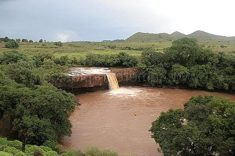
The Vina River flows quietly through the highlands of Cameroon’s Adamawa Region, carving a meandering path across grass-covered plateaus, scattered hills, and fertile valleys. Though not among the country’s longest or most dramatic rivers, it plays a steady, life-shaping role in the ecosystems and communities of central Cameroon, particularly around Ngaoundéré, the region’s main city.
Source and Course
The Vina River rises near the high-altitude slopes of Mount Ngan-Ha, part of the Cameroon Volcanic Line. From there, it flows northward and eastward across the Adamawa Plateau, descending gradually through a series of wide, open valleys. The river is part of the Lake Chad Basin drainage system, eventually contributing to the Logone River, which joins the Chari River further north.
As it moves downstream, the Vina gathers seasonal tributaries and rainwater runoff, particularly during the May to October rainy season, when its volume increases and floodplains expand. In the dry months, its flow lessens, exposing sandbanks and creating shallow pools where birds and livestock gather.
Landscape and Surroundings
The river winds through an open highland landscape dominated by savanna grassland, gallery forests, and gently eroded volcanic hills. Its banks support lush strips of vegetation - palms, raffia, reeds, and moisture-loving shrubs - that stand out against the dry grasses of the plateau.
These green corridors along the river, known as gallery forests, form important ecological ribbons. They serve as habitat corridors for birds, amphibians, and small mammals, and they help protect the riverbanks from erosion. In some places, the river forms calm bends and natural basins where fishing, bathing, and watering of animals take place.
Human Life and Use
The Vina River is deeply embedded in local rural life. Villages and hamlets use its water for drinking, irrigation, fishing, and livestock, especially during the long dry season when other sources may run low. Along its banks, you'll often see herders watering cattle, farmers tending to riverside plots, or children splashing in shallow sections after school.
In Ngaoundéré, the river plays a subtle but essential role in supporting both the urban water supply and peri-urban agriculture. It’s not grand or ceremonious - more of a practical companion than a dramatic landmark - but its presence is felt everywhere in daily routine.
Ecology and Seasonal Rhythm
The Vina’s character changes with the seasons. During the wet months, it swells, feeding temporary wetlands and supporting rice farming, fish reproduction, and the migration of water birds. The water takes on a reddish tint from the lateritic soils it carries, and the air grows thick with insects and plant scents.
In the dry season, it contracts, revealing exposed stones, sandy beds, and sluggish flows. Birds gather at remaining pools, and herders follow the river’s course in search of greener pastures. The rhythms of the river dictate human movement, planting cycles, and ecological patterns all across the region.
Overall Impression
The Vina River is not a river of spectacle but of constancy. It flows without drama, yet it underpins much of life in Cameroon’s high central plateau. It mirrors the Adamawa Region’s quiet strength - dependable, broad, and shaped by rhythm rather than speed. Following its path, one glimpses a deeper layer of the landscape: the long seasonal dialogue between land, water, and people that has sustained this region for generations.