Information
City: New AlbanyCountry: USA Indiana
Continent: North America
New Albany, USA Indiana, North America
New Albany is an independent city and the seat of Floyd County, situated on the Ohio River directly across from Louisville, Kentucky. It is defined by its 19th-century "Golden Age" as a premier shipbuilding center, its concentration of high-style Victorian architecture, and its modern role as a major culinary and boutique commercial hub within the Louisville metropolitan area.
Historical Timeline
Inhabited by the Shawnee and Delaware peoples. Primary governance eras include its 1813 founding by the Scribner brothers and its mid-19th-century status as the largest city in Indiana (surpassing Indianapolis until 1860). A critical historical event was the 1852 founding of the New Albany and Salem Railroad (later the Monon), which, combined with the city's steamboat industry, turned it into a massive regional economic engine. In the 20th century, New Albany became the world's leading producer of plywood and veneers. The 21st century has been characterized by a significant downtown renaissance driven by independent restaurants and the "Main Street" revitalization program.
Demographics & Population
The population is approximately 37,500. The demographics are White (80%), Black or African American (11%), Hispanic or Latino (5%), and Asian (1%). The economy is integrated with the Louisville regional market, supported by a mix of healthcare, logistics, and a thriving local small-business sector.
Urban Layout & Key Districts
New Albany is organized on a grid following the Ohio River, rising from the riverfront to the "Knobs" (steep hills) to the north.
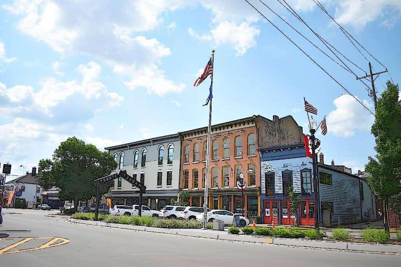
Downtown: The historic and commercial core, featuring one of the most vibrant independent restaurant scenes in the Midwest and high-density 19th-century commercial blocks.
Mansion Row: A stretch of Main Street featuring a premier collection of Federal, Greek Revival, and Italianate mansions built by steamboat tycoons.
Vincennes Street: A historic commercial corridor currently undergoing infrastructure upgrades and small-business revitalization.
The Knobs: A residential area on the high bluffs overlooking the city, offering expansive views and upscale suburban housing.
West End: A historically working-class residential district featuring shotgun-style homes and early 20th-century bungalows.
Top City Landmarks
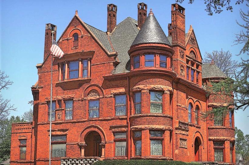
Culbertson Mansion State Historic Site: A 25-room French Second Empire mansion built in 1867, showcasing the extreme wealth of the city’s industrial era.
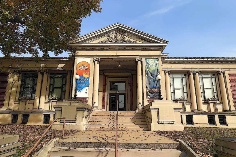
Carnegie Center for Art & History: A contemporary art museum and local history center housed in a 1904 Beaux-Arts library.
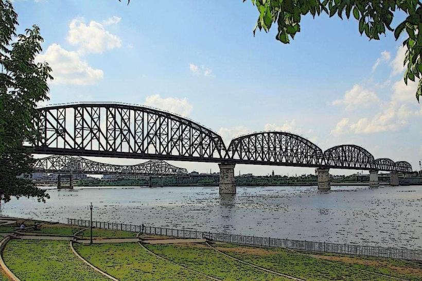
The Sherman Minton Bridge: A unique double-deck arch bridge connecting New Albany to Louisville.
Scribner House: The 1814 Federal-style home of the city's founding family, the oldest building in New Albany.
Riverfront Amphitheater: A primary venue for outdoor concerts and festivals with views of the Louisville skyline.
Silver Creek Park: A large recreational area on the eastern edge of the city bordering Clarksville.
Transportation Network
Movement is automotive-dependent but supported by TARC (Transit Authority of River City), which provides bus links to Louisville. The city is a major junction for I-64, I-265, and US-150. Commercial air service is via Louisville Muhammad Ali International (SDF), 20 km southeast. The city is increasingly bike-friendly, with connections to the Ohio River Greenway. Traffic is heavy on the Sherman Minton Bridge during morning and evening commutes.
Safety & "Red Zones"
The general safety level is moderate. Property crime and narcotics-related activity in specific high-density residential areas are the primary concerns. Caution is advised at night in parts of the Midtown area and specific blocks in the West End due to localized vagrancy and property crime. There are no officially designated "red zones." Environmental hazards include seasonal river flooding along the Ohio and fog in the river valley.
Digital & Financial Infrastructure
Internet speeds average 500+ Mbps with fiber availability via AT&T Fiber, Spectrum, and Metronet. Main mobile carriers are Verizon and AT&T. Card acceptance is universal in the downtown core. ATMs are concentrated on State Street and Main Street.
Climate & Air Quality
Temperatures range from -3°C to 7°C in winter and 21°C to 32°C in summer. The city experiences high humidity due to the Ohio River. Air quality is moderate, often influenced by the regional industrial activity of the Louisville-Jefferson County metro area.
Culture & Social Norms
The standard tipping percentage is 20–25%. A handshake is the standard greeting. Dress codes are "Urban-Casual" or "Boutique-Chic." The city is culturally defined by its "indie" spirit, its deep-seated pride in its steamboat history, and its status as a "foodie" destination.
Accommodation Zones
Downtown New Albany: Recommended for boutique lofts and walkable access to nightlife.
I-64 / Grant Line Road: Recommended for standard national hotel chains and suburban convenience.
Local Cost Index
1 Espresso: $4.50 (USD)
1 Standard Lunch: $18.00 (USD)
1 Culbertson Mansion Tour: $12.00.
Nearby Day Trips
Louisville, KY: (Directly across the river).
Falls of the Ohio State Park: (5 km east in Clarksville; world-class fossil beds).
Huber’s Orchard & Winery: (20 km north in Starlight, IN).
Facts & Legends
New Albany was once the wealthiest city in Indiana. Historically, it was the site where the Robert E. Lee steamboat was partially outfitted for its famous race against the Natchez. A local legend involves the "Ghost of the Culbertson Mansion," with rumored spectral activity in the servant quarters. Another legend concerns "The Scribner Secret," referring to rumored hidden compartments in the city's oldest homes used as part of the Underground Railroad.