Information
Landmark: Cenote de la CuevaCity: Merida City
Country: Mexico
Continent: North America
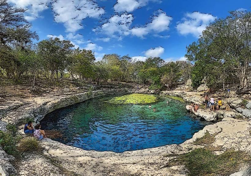
Cenote de la Cueva, Merida City, Mexico, North America
Cenote de la Cueva is a natural sinkhole located approximately 15 kilometers south of Merida City, Mexico.
This geological formation offers a subterranean swimming experience within a cave system.
Visual Characteristics
The cenote is an open-air sinkhole with a diameter of approximately 20 meters. The water is clear and exhibits a blue-green hue. Stalactites and stalagmites are present on the cave walls and ceiling. The surrounding vegetation is dense jungle growth.
Location & Access Logistics
Access is via Highway 180D (Merida-Cancun toll road) heading south. Take exit 112 towards San Antonio Hool. The cenote is located 1 kilometer east of San Antonio Hool on a paved access road. Parking is available on-site. Public transport options are limited; local buses to San Antonio Hool are available from Merida's main bus terminal, followed by a 1km walk or taxi.
Historical & Ecological Origin
Cenote de la Cueva is a natural sinkhole formed by the dissolution of limestone bedrock, a common geological process in the Yucatan Peninsula. It is part of the extensive underground river system characteristic of the region.
Key Highlights & Activities
Swimming and snorkeling are the primary activities. A wooden platform provides access to the water. Life vests are available for rent. The cave system can be explored to a limited extent.
Infrastructure & Amenities
Restrooms are available on-site. Shade structures are present near the entrance. Cell phone signal (4G) is intermittent. Small food vendors operate near the entrance during peak hours.
Best Time to Visit
For optimal lighting within the cave, visit between 11:00 AM and 2:00 PM when sunlight penetrates the opening. The dry season, from November to April, generally offers the most pleasant weather conditions.
Facts & Legends
Local lore suggests that the cenote was used for ceremonial purposes by the ancient Maya. The water level is relatively constant throughout the year, unaffected by surface rainfall.
Nearby Landmarks
- 0.8km West: San Antonio Hool Village
- 3.5km North: Hacienda San Antonio Hool
- 4.2km Northeast: Cenote X'batun
- 5.0km Southwest: Archaeological Zone of Mayapan