Information
Landmark: Iron Mountain RoadCity: Custer
Country: USA South Dakota
Continent: North America
Iron Mountain Road, Custer, USA South Dakota, North America
Overview and Setting
Iron Mountain Road, officially designated U.S. Route 16A, is one of the most scenic and ingeniously designed drives in the United States. Winding through the Black Hills of South Dakota, this 17-mile stretch connects Custer-state-park_custer" class="underline">Custer State Park with the Mount Rushmore National Memorial, offering drivers a journey that’s as much an experience as it is a route.
Built in the 1930s under the direction of Governor Peter Norbeck, the same visionary behind the Needles Highway, Iron Mountain Road was deliberately engineered to highlight the Black Hills’ natural grandeur. It climbs, curves, and tunnels its way through pine forests, granite peaks, and rolling meadows-revealing breathtaking, almost cinematic views at every turn.
Design and Construction
Iron Mountain Road is a masterpiece of road engineering and scenic design. Norbeck insisted that the road blend seamlessly with the land, preserving its wild beauty while providing travelers with moments of surprise and awe.
The route features:
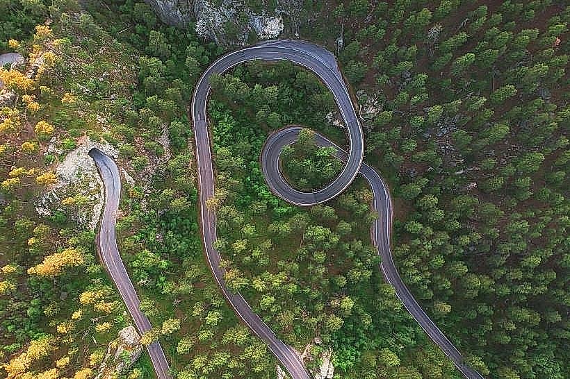
314 curves that twist and wind through the landscape, encouraging slow, immersive driving.
14 switchbacks and 3 pigtail bridges, where the road loops over itself in graceful wooden spirals built from local timber.
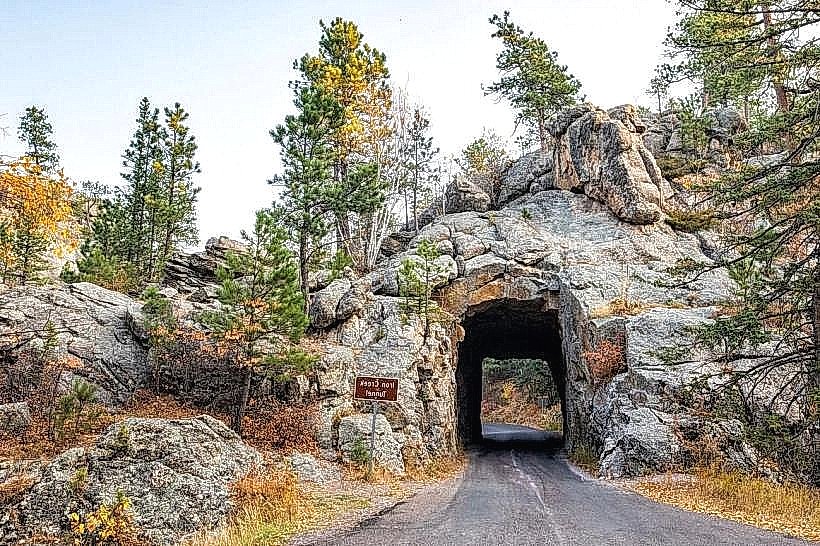
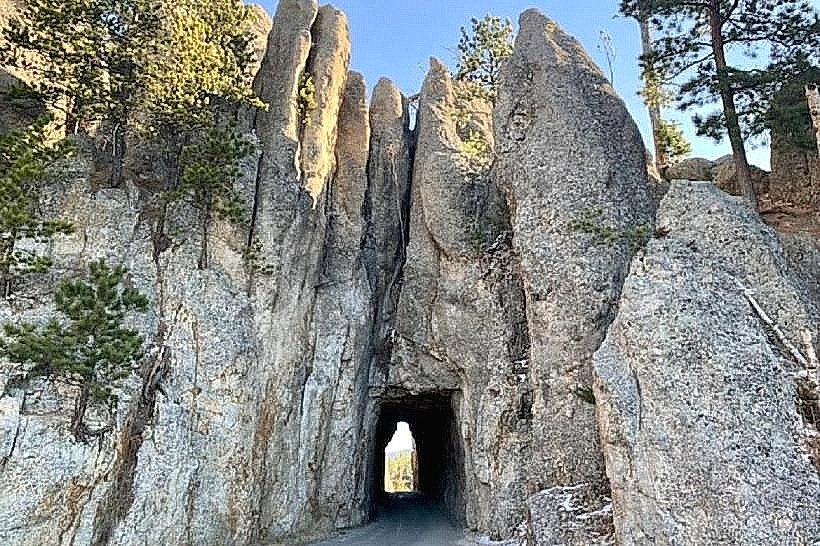
3 narrow rock tunnels, each perfectly aligned to frame the distant faces of Mount Rushmore-an intentional and iconic design choice.
The tunnels-Doane Robinson Tunnel, C.C. Gideon Tunnel, and Scovel Johnson Tunnel-are narrow and hand-carved, with rugged rock walls that seem to close in as you pass through. Emerging from one of these tunnels to see the stony faces of Washington, Jefferson, Roosevelt, and Lincoln in perfect alignment is one of the most memorable moments of any South Dakota road trip.
The Driving Experience
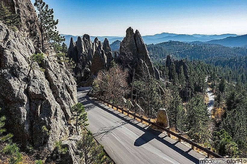
Driving Iron Mountain Road isn’t about speed-it’s about savoring every curve, every change in light, and every glimpse of the forested Black Hills. The road’s tight turns and steep grades demand attention and patience, but they also create a sense of discovery that few other highways can match.
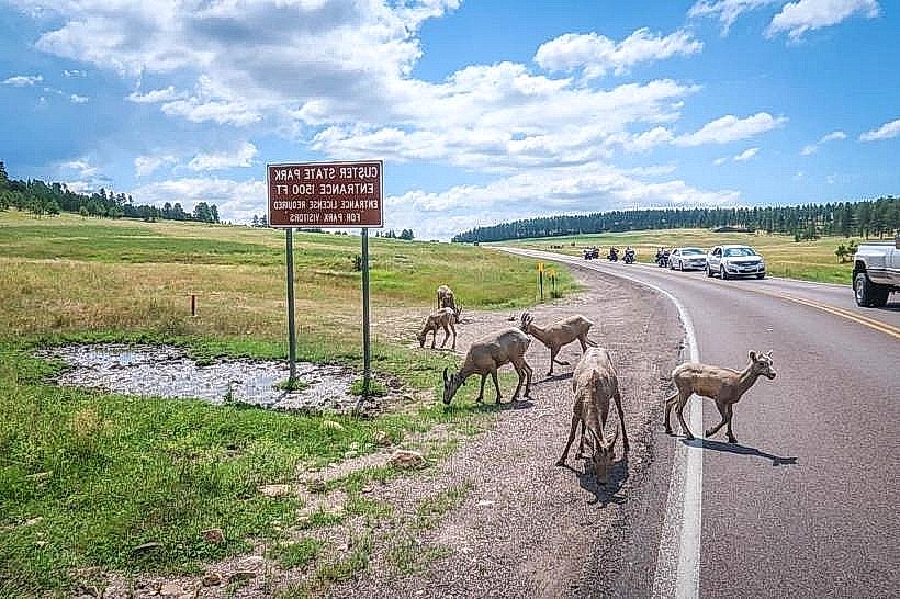
Along the way, the elevation changes from around 3,500 to over 5,000 feet, offering shifting perspectives of the pine-clad hills. The scent of pine resin and the sound of wind filtering through the trees accompany the drive. Wildlife is often spotted: bison, white-tailed deer, wild turkeys, and mountain goats roam freely along the roadside.
Key Highlights and Stops
Pigtail Bridges: Ingenious wooden structures where the road loops over itself in corkscrew fashion, allowing for elevation gain without disturbing the landscape.
Scenic Overlooks: Pullouts provide panoramic views of the Black Hills and the distant sculpture of Mount Rushmore.
Norbeck Overlook: A favorite viewpoint offering a wide, unobstructed view of the monument and surrounding hills.
Iron Mountain Picnic Area: A peaceful stop among tall pines-ideal for a short rest before continuing the winding descent.
Atmosphere and Character
Iron Mountain Road feels like a moving meditation through the Black Hills. The ever-changing rhythm of curves, tunnels, and bridges creates a sense of flow and wonder. The craftsmanship of the 1930s Civilian Conservation Corps work is still visible in every detail-from the handcrafted stonework to the wooden guardrails that follow the terrain like ribbons of artistry.
Governor Norbeck once said he built the road “for people who have time to enjoy it,” and that philosophy still defines the experience today. It’s a road meant to be driven slowly, ideally with the windows down, letting the scent of pine and the cool mountain breeze become part of the memory.
Practical Information
Length: Approximately 17 miles (between Custer State Park and Mount Rushmore)
Open Season: Typically late May to mid-October (closed in winter due to snow)
Speed Limit: 25 mph or lower due to sharp curves and tunnels
Best Time to Drive: Early morning or late afternoon for softer light and fewer vehicles
Vehicle Size Restrictions: Large RVs and trailers are not recommended because of the narrow tunnels and tight curves
Legacy and Spirit
Iron Mountain Road isn’t just a link between landmarks-it’s a living monument to craftsmanship, vision, and respect for the natural world. It reflects a time when road building was an art form and when engineers sought to make travelers feel part of the land rather than distant from it.
By the time you reach the end of the drive, you don’t just see Mount Rushmore-you’ve experienced the Black Hills, their serenity, their mystery, and their enduring power.