Information
Landmark: Kapetanovo LakeCity: Niksic
Country: Montenegro
Continent: Europe
Kapetanovo Lake, Niksic, Montenegro, Europe
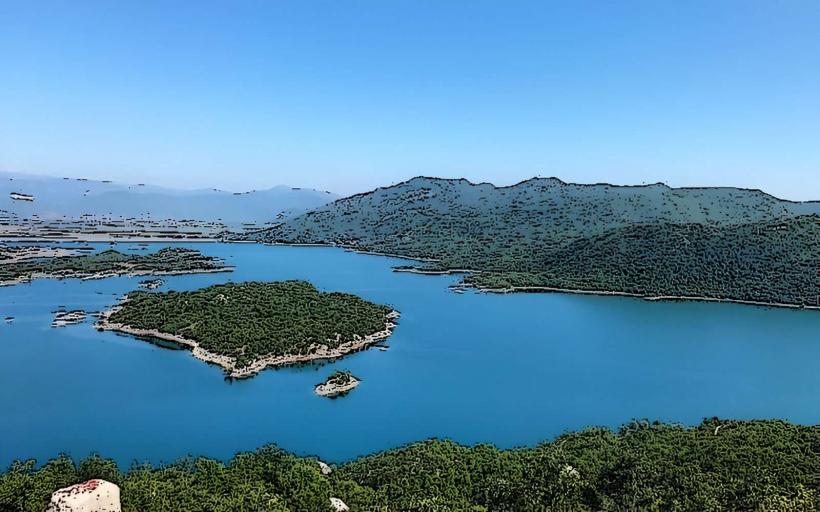
Kapetanovo Lake (Kapetanovo jezero) is a high-altitude glacial lake situated in the Morača Mountains, located on the border between the Nikšić and Kolašin municipalities. It is positioned at an elevation of 1,678 meters above sea level and is considered one of the most prominent natural landmarks of the Montenegrin highlands.
Visual Characteristics
The lake is characterized by its clear, deep-blue water and its symmetrical, roughly oval shape. It is nestled in a glacial cirque surrounded by steep limestone peaks, most notably the Mali Žurim and Veliki Žurim ridges. The shoreline consists of alpine meadows and rocky scree, with several traditional stone "katuns" (seasonal shepherd huts) clustered at the water’s edge. The water transparency remains high throughout the year, reflecting the surrounding karst topography.
Location & Access Logistics
The lake is located approximately 45 kilometers east of Nikšić. Access is logistically challenging and typically requires a 4x4 vehicle. The primary route starts from Nikšić via the village of Bare Bojovića; the final 10–12 kilometers consist of a rough, unpaved mountain track. Pedestrian access is possible via marked hiking trails from the Morača Monastery or the Lukavica plateau. There is no public transportation. During winter (November–May), the access roads are typically blocked by heavy snow, making the lake reachable only by professional mountaineering equipment.
Historical & Ecological Origin
The lake is of glacial origin, formed during the Pleistocene epoch within a limestone depression. It is approximately 37 meters deep at its maximum point. Historically, the area has served as a primary summer pasturage for nomadic herders. Ecologically, the lake is a sensitive high-alpine ecosystem, supporting endemic Balkan flora and serving as a critical water source for local wildlife and livestock.
Key Highlights & Activities
Logistical activities focus on mountain tourism, including trekking, mountain biking, and off-road driving. The lake is a popular spot for fly fishing, as it is naturally stocked with trout. Visitors can experience the traditional "katun" lifestyle, with some shepherds offering local dairy products like "skorup" (cream) and cheese. The nearby Manito Lake is reachable via a 40-minute uphill hike, providing a higher-altitude perspective of the region.
Infrastructure & Amenities
Infrastructure is minimal and rustic. There are several small stone huts that offer basic lodging and traditional food during the summer months. There are no paved roads, public restrooms, or electricity grids; power is typically provided by small solar panels or generators. 4G cellular signal is intermittent and highly dependent on the specific ridge position. There is no natural shade provided by trees, as the lake is located above the forest line.
Best Time to Visit
The optimal window for visiting is from late June to September, when the snow has melted and the mountain tracks are navigable. Photography is best during the early morning for mirror-like water reflections or late afternoon for the "golden hour" lighting on the Žurim peaks. High-altitude weather is volatile; rapid temperature drops and thunderstorms are common even in mid-summer.
Facts & Legends
The lake is named after Captain Mušović, a local Ottoman official from Nikšić. Legend states that the lake was created by mountain fairies who opened a hidden spring to punish the Captain for claiming the land; the water supposedly flooded his meadows until it formed the lake seen today. A technical fact is that the lake is a "closed" system with no visible surface outflow, as its waters drain through underground karst channels.
Nearby Landmarks
Manito Lake (Brnjičko jezero) – 1.5km East (uphill)
Mali Žurim Peak – 3.0km West
Veliki Žurim Peak – 4.0km West
Lukavica Plateau – 5.0km West
Morača Monastery – 15.0km East (via mountain trail)