Information
City: WaimeaCountry: USA Hawaii
Continent: North America
Waimea, USA Hawaii, North America
Waimea (also known as Kamuela) functions as the primary center for the Hawaiian ranching industry and a critical logistical hub for international astronomical research. The town is situated in the Kohala Mountains of the Island of Hawaiʻi, at an elevation of approximately 814 meters above sea level.
Historical Timeline
Waimea was established as a significant settlement in the early 19th century following the arrival of John Palmer Parker, who founded the Parker Ranch in 1847. Primary governance shifted from the Hawaiian Kingdom to U.S. Territorial control in 1898. During World War II, the town underwent a massive temporary reconstruction as "Camp Tarawa," housing over 50,000 U.S. Marines for training. The primary event shaping the current urban form was the mid-20th-century transition of Parker Ranch from a private estate to a diversified land-management trust, which facilitated the development of the town's modern commercial and residential infrastructure.
Demographics & Population
The census-designated place (CDP) of Waimea has a population of approximately 10,000. The top three demographics are White (31.2%), Asian (20.5%), and Native Hawaiian or Pacific Islander (15.8%), with a high percentage of multiracial residents (28%). The median age is 39.4 years.
Urban Layout & Key Districts
The town is organized around the intersection of Mamalahoa Highway (Route 190) and Kawaihae Road (Route 19). Town Center (Central) contains the primary retail hubs and Parker Ranch headquarters. Lalamilo (West) is the primary residential and agricultural farm lot district. Nob Hill (North) features higher-elevation residential estates. The town is uniquely divided into "Wet Side" (East) and "Dry Side" (West), split by a distinct climatic line near the town center.
Top City Landmarks
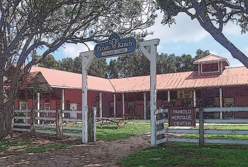
Parker Ranch Center and Historic Homes (Mana Road)
W.M. Keck Observatory Headquarters
Canada-France-Hawaii Telescope (CFHT) Headquarters
Kahilu Theatre
Anna Ranch Heritage Center
Transportation Network
Internal movement is primarily via private vehicle. The Hele-On Bus provides regional connections to Hilo, Kailua-Kona, and the Kohala Coast resorts. There are no metro or tram lines. Ride-sharing via Uber and Lyft is available but has low vehicle density compared to coastal areas. Official taxis are rare and must be pre-arranged from Kailua-Kona or the Kohala Coast. Traffic density is moderate, with peak congestion occurring at the central intersection during school drop-off and pickup hours.
Safety & "Red Zones"
Waimea is statistically one of the safest towns in the state. Physical "Red Zones" include Mana Road during heavy rain, which requires 4WD and is prone to washouts. Pedestrians should avoid walking along the narrow shoulders of Kawaihae Road at night due to frequent fog and lack of street lighting. Common scams are nearly non-existent, though travelers may be overcharged for "local" beef that is not sourced from the surrounding ranches.
Digital & Financial Infrastructure
Internet speeds average 200–400 Mbps. Main mobile carriers are Verizon, AT&T, and T-Mobile. Card acceptance is universal in the town center, though the Saturday Farmers Markets (e.g., Parker School or Pukalani Stables) frequently require cash or digital peer-to-peer payments. ATMs are located at all major bank branches (Bank of Hawaii, First Hawaiian, HawaiiUSA) within the town core.
Climate & Air Quality
Temperatures range from 10°C to 24°C; the town is significantly cooler than the coastal regions. Air quality is exceptionally high due to elevation and trade winds, though it is subject to "Vog" (volcanic smog) during southerly wind patterns. Significant weather risks include heavy mountain fog (locally called "Uhu") and occasional high-wind events descending from the Kohala Mountains.
Culture & Social Norms
Tipping follows the U.S. standard of 18–22%. The culture is defined by "Paniolo" (Hawaiian Cowboy) traditions; greetings are friendly and often include a handshake. Dress is more rugged than the coast, with jeans, boots, and jackets being standard due to the cooler climate. Smoking is prohibited in all public parks. Alcohol consumption is restricted to licensed restaurants and private residences.
Accommodation Zones
Town Center: Stay here for walking access to groceries, cafes, and the Keck/CFHT headquarters.
Kawaihae Road (West): Stay here for "Dry Side" weather and quicker access to the Kohala Coast beaches.
Local Cost Index
1 Espresso: $6.00
1 Standard Lunch (Grass-fed Burger): $21.00
1 Hele-On Bus Ticket: $2.00
Nearby Day Trips
Hapuna Beach State Park: 24 km (25 minutes), one of the island's largest white sand beaches.
Pololu Valley Overlook: 45 km (50 minutes), featuring dramatic northern sea cliffs.
Mauna Kea Visitor Information Station: 55 km (1 hour), the gateway to the world's premier astronomical site.
Facts & Legends
Waimea is the birthplace of the Paniolo culture; in 1832, King Kamehameha III brought Spanish-Mexican vaqueros to teach Hawaiians how to manage wild cattle, predating the American "Old West" cowboy by decades. A local legend involves the "Green Lady" of the Kohala mountains, a forest spirit said to protect the sandalwood trees; ranchers occasionally report seeing a green mist or figure when searching for lost cattle in the high-elevation fog.